
Near Winchester in Frederick County, Virginia — The American South (Mid-Atlantic)
The Third Battle of Winchester
The Confederates Reform
Photographed by Craig Swain, August 26, 2007
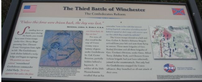
1. The Third Battle of Winchester Marker
"Unless this force were driven back, the day was lost."
General Jubal A. Early, C.S.A.
Standing here about noon during the battle, you would have seen Union troops under Gen. Henry Birge pursuing Gen. Clement Evans' Georgians from right to left. The Confederates took shelter behind a rocky ledge and began to regroup. "The position was most critical," remembered Confederate commander Jubal Early, "for it was apparent that unless this force were driven back, the day was lost."
For now, all that stood in the way of a Union victory was a battery of guns under Confederate Lt. Col. Carter Braxton, partially hidden behind a haystack. A soldier of the 26th Massachusetts recalled that as his comrades "came in line with that innocent looking haystack, some pieces of artillery masked behind it opened at short range with canister upon our line which they completely enfiladed."
The Union troops slowed to a halt and Gen. Cullen A. Battle's Alabama Brigade arrived from your left and sent them flying in retreat. Three more brigades of Gen. Rodes' Division and all three brigades of Gen. Gordon's Division, under Gens. Alfred Terry, Zebulon York,
this page online
Erected by Civil War Preservation Trust.
Topics. This historical marker is listed in this topic list: War, US Civil.
Location. Marker has been reported permanently removed. It was located near 39° 11.986′ N, 78° 7.964′ W. Marker was near Winchester, Virginia, in Frederick County. It could be reached from Redbud Road (County Route 661), on the right when traveling east. Located at the Confederates Reform Wayside, along the Battle Trail, inside the CWPT Third Winchester Battlefield site. This wayside is about a hundred yards southeast of I-81, without direct access to the highway. The closest trailhead to this marker is along Redbud Road. Touch for map. Marker was in this post office area: Winchester VA 22603, United States of America.
We have been informed that this marker is no longer there and will not be replaced. This page is an archival view of what was.
Regionally, this marker was in Virginia’s

2. Help Preserve 3rd Winchester
Details of CWPT efforts to save this battlefield.
Click for more information.
Click for more information.

Other nearby markers. At least 8 other markers are within walking distance of this location: Breaking the Deadlock (within shouting distance of this marker); Bloody Repulse (about 700 feet away); Major General Robert Emmett Rodes (approx. 0.2 miles away); Counterattack! (approx. 0.2 miles away); Hackwood And Patton (approx. 0.3 miles away); Tigers from the Woods (approx. 0.3 miles away); Union Breakthrough (approx. 0.3 miles away); Alabama (approx. 0.3 miles away). Touch for a list and map of all markers in Winchester.
Other markers no longer nearby. The Third Battle of Winchester (was about 600 feet away, measured in a direct line but has been permanently removed); a different marker also named The Third Battle of Winchester
Photographed by Craig Swain, August 26, 2007
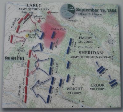
3. The Battle Map
Note the location of the rocky ledge, which is now where I-81 passes.
A Virtual Tour of the Third Winchester Battlefield by HMDb markers:
Click for more information.
A Virtual Tour of the Third Winchester Battlefield by HMDb markers:
Click for more information.
More about this marker. On the left side of the marker is a copy of a map captioned, In 1883 a group of Civil War veterans gathered at Winchester and camped on the hill in front of you. They doubtless visited the "rocky ledge" behind which Evans' men took cover (destroyed by the construction of I-81) and noted the set of stumps which marked the former Second Woods.
Photographed by Craig Swain, August 26, 2007
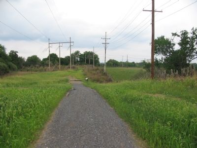
4. The Confederate's Reform Wayside
The I-81 bypass around Winchester is just beyond the tree line behind the utility poles. The battlefield is significantly altered from it's 1864 state in this location.
Also see . . . Summary of the Battle of Third Winchester. National Parks Service website entry (Submitted on October 27, 2007, by Craig Swain of Leesburg, Virginia.)
Photographed by Craig Swain, August 26, 2007
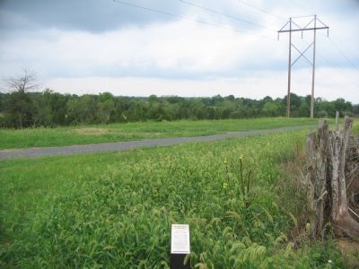
5. The Confederate Counterattack
Looking past the Battle Line trail, at the I-81 bypass, this is the direction from which the Confederates under Gordon advanced. Just under a mile west of this spot is Fort Collier, one of the Confederate strongholds defending Winchester. The Confederates Reform wayside is just out of view to the right side of this photo.
Photographed by Craig Swain, August 26, 2007
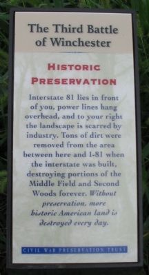
6. Historic Preservation Trail Sign
Next to the trail is this sign:
The Third Battle of Winchester
Historic Preservation
Interstate 81 lies in front of you, power lines hang overhead, and to your right the landscape is scarred by industry. Tons of dirt were removed from the area between here and I-81 when the interstate was built, destroying portions of the Middle Field and Second Woods forever. Without preservation, more historic American land is destroyed every day.
The Third Battle of Winchester
Historic Preservation
Interstate 81 lies in front of you, power lines hang overhead, and to your right the landscape is scarred by industry. Tons of dirt were removed from the area between here and I-81 when the interstate was built, destroying portions of the Middle Field and Second Woods forever. Without preservation, more historic American land is destroyed every day.
Credits. This page was last revised on February 18, 2025. It was originally submitted on October 27, 2007. This page has been viewed 1,768 times since then and 14 times this year. Last updated on November 2, 2020. Photos: 1. submitted on October 27, 2007, by Craig Swain of Leesburg, Virginia. 2. submitted on March 13, 2009, by Craig Swain of Leesburg, Virginia. 3, 4, 5, 6. submitted on October 27, 2007, by Craig Swain of Leesburg, Virginia. • J. Makali Bruton was the editor who published this page.
