Winchester in Clark County, Kentucky — The American South (East South Central)
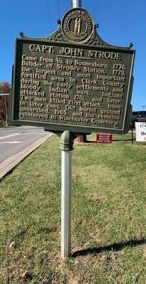
Capt. John Strode
Erected 1967 by Kentucky Historical Society and Kentucky Department of Highways. (Marker Number 1047.)
Topics and series. This historical marker is listed in these topic lists: Cemeteries & Burial Sites • Forts and Castles • Settlements & Settlers • War, French and Indian. In addition, it is included in the Kentucky Historical Society series list. A significant historical year for this entry is 1776.
Location. 38° 0.534′ N, 84° 12.882′ W. Marker is in Winchester, Kentucky, in Clark County. Marker is on West Lexington Avenue (U.S. 60) just east of Hospital Drive, on the right when traveling west. Marker is on roadside of US 6o West Lexington Ave. You can park at the Cookout(Current Business) 100 Hospital Dr. Touch for map. Marker is at or near this postal address: 1600 W Lexington Ave, Winchester KY 40391, United States of America. Touch for directions.
Other nearby markers. At least 8 other markers are within 3 miles of this marker, measured as the crow flies. Allen Tate (1899-1978) (approx. 1.2 miles away); Daniel Boone (approx. 2 miles away); Homer C. Ledford (approx. 2 miles away); Hanson Home Site (approx. 2 miles away); Governor James Clark (approx. 2.1 miles away); Clark County War Memorial (approx. 2.3 miles away); Vietnam War Memorial (approx. 2.3 miles away); County Named 1793 (approx. 2.3 miles away). Touch for a list and map of all markers in Winchester.
Credits. This page was last revised on November 10, 2020. It was originally submitted on November 10, 2020, by Frank Profitt of Georgetown, Kentucky. This page has been viewed 932 times since then and 143 times this year. Photo 1. submitted on November 10, 2020, by Frank Profitt of Georgetown, Kentucky. • Devry Becker Jones was the editor who published this page.
Editor’s want-list for this marker. A wide shot of the marker in context. • Can you help?
