Near Hickory Grove in Greenbrier County, West Virginia — The American South (Appalachia)
Blue Sulphur Springs, WV
Pavilion
Brief History:
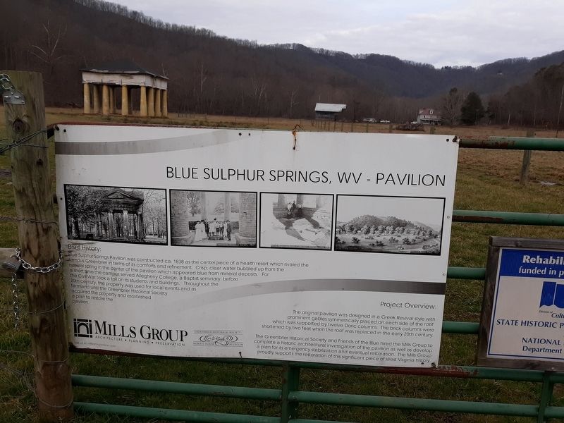
Blue Sulphur Springs Pavilion was constructed ca. 1838 as a centerpiece of a health resort which rivaled the famous Greenbrier in terms of its comforts and refinement. Crisp, clear water bubbled up from the natural spring in the center of the pavilion which appeared blue from mineral deposits. For a short time the campus served Allegheny College, a Baptist seminary, before the Civil War took a toll on its students and buildings. Throughout the 20th century, the property was used for local events and as acquired the property and established a plan to restore the pavilion.
Project Overview:
The original pavilion was designed in a Greek Revival style with prominent gables symmetrically placed on each side of the roof, which was supported be twelve Doric columns. The brick columns were shortened by two feet when the roof was replaced in the early 20th century. The Greenbrier Historical Society and Friends of the Blue hired the Mills Group to complete a historic architectural investigation of the pavilion as well as develop a plan for its emergency stabilization and eventual restoration. The Mills Group proudly supports the restoration of this significant piece of West Virginia history.
Erected by The Greenbrier Historical Society.
Topics. This historical marker is listed in these topic lists: Industry & Commerce • Parks & Recreational Areas • Science & Medicine • Waterways & Vessels. A significant historical year for this entry is 1838.
Location. 37° 49.683′ N, 80° 38.283′ W. Marker is near Hickory Grove, West Virginia, in Greenbrier County. Marker is on Blue Sulphur Springs Road (County Road 25) just south of Spring Valley Road (County Road 31), on the right when traveling north. Touch for map. Marker is at or near this postal address: 7981 Blue Sulphur Rd, Alderson WV 24910, United States of America. Touch for directions.
Other nearby markers. At least 8 other markers are within 7 miles of this marker, measured as the crow flies. The Pavilion (here, next to this marker); Blue Sulphur Springs Confederate Burial Ground (approx. 0.2 miles away); Unknown Soldiers/ Gen. Lewis' Trace (approx. 4.1 miles away); Sam Black Church (approx. 4.9 miles away); Greenbrier Ghost (approx. 5.1 miles away); Maxon Sand (approx. 5.2 miles away); Andrew & Charles Lewis March (approx. 5.9 miles away); Greenbrier County / Summers County (approx. 6.8 miles away).
Credits. This page was last revised on December 7, 2021. It was originally submitted on November 10, 2020, by Craig Doda of Napoleon, Ohio. This page has been viewed 340 times since then and 26 times this year. Photo 1. submitted on November 10, 2020, by Craig Doda of Napoleon, Ohio. • Devry Becker Jones was the editor who published this page.
Editor’s want-list for this marker. A wide shot of the marker in context. • Can you help?
