Reading in Berks County, Pennsylvania — The American Northeast (Mid-Atlantic)
Angelica Creek Park
Site History
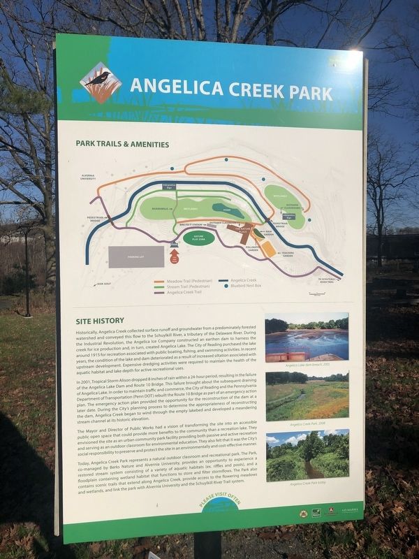
Historically, Angelica Creek collected surface runoff and groundwater from a predominantly forested watershed and conveyed this flow to the Schuylkill River, a tributary of the Delaware River. During the Industrial Revolution, the Angelica Ice Company constructed an earthen dam to harness the creek for ice production and, in turn, created Angelica Lake. The City of Reading purchased the lake around 1915 for recreation associated with public boating, fishing, and swimming activities. In recent years, the condition of the lake and dam deteriorated as a result of increased siltation associated with upstream development. Expensive dredging activities were required to maintain the health of the aquatic habitat and lake depth for active recreational uses.
In 2001, Tropical Storm Alison dropped 8 inches of rain within a 24-hour period, resulting in the failure of the Angelica Lake Dam and Route 10 Bridge. This failure brought about the subsequent draining of Angelica Lake. In order to maintain traffic and commerce, the city of Reading and the Pennsylvania Department of Transportation (Penn DOT) rebuilt the Route 10 Bridge as part of an emergency action plan. The emergency action plan provided the opportunity for the reconstruction of the dam at a later date. During the City's planning process to determine the appropriateness of reconstructing the dam, Angelica Creek began to wind through the empty lakebed and developed a meandering stream channel at its historic elevation.
The Mayor and Director of Public Works had a vision of transforming the site into an accessible public space that could provide more benefits to the community than a recreation lake. They envisioned the site as an urban community park facility providing both passive and active recreation and serving as an outdoor classroom for environmental education. They also felt that it was the City's social responsibility to preserve and protect the site in an environmentally and cost-effective manner.
Today, Angelica Creek Park represents a natural outdoor classroom and recreational park. The Park, co-managed by Berks Nature and Alvernia University, provides an opportunity to experience a restored stream system consisting of a variety of aquatic habitats (ex. riffles and pools, and a floodplain containing wetland habitat that functions to store and filter stormflows. The Park also contains scenic trails that extend along Angelica Creek, provide access to the flowering meadows and wetlands, and link the park with Alvernia University and the Schuylkill River Trail system.
Erected by City of Reading, Pennsylvania; Berks Nature; Alvernia University;
Topics. This historical marker is listed in these topic lists: Environment • Industry & Commerce • Parks & Recreational Areas • Waterways & Vessels. A significant historical year for this entry is 1915.
Location. 40° 18.683′ N, 75° 55.659′ W. Marker is in Reading, Pennsylvania, in Berks County. Marker is on Saint Bernardine Street, 0.2 miles west of Morgantown Road (Pennsylvania Route 10), on the right when traveling west. Touch for map. Marker is at or near this postal address: 560 St Bernardine St, Reading PA 19607, United States of America. Touch for directions.
Other nearby markers. At least 8 other markers are within walking distance of this marker. Reading & Berks County (approx. 0.3 miles away); Soldiers and Sailors Monument (approx. 0.6 miles away); Kenhorst (approx. 0.8 miles away); The Dead Have No Rights (approx. 0.8 miles away); Jackson’s Lock and the Port of Reading (approx. 0.9 miles away); a different marker also named Jackson's Lock and the Port of Reading (approx. 0.9 miles away); James H. Maurer (approx. 0.9 miles away); Union Canal (approx. 0.9 miles away). Touch for a list and map of all markers in Reading.
Credits. This page was last revised on November 21, 2020. It was originally submitted on November 21, 2020, by Devry Becker Jones of Washington, District of Columbia. This page has been viewed 385 times since then and 41 times this year. Photos: 1, 2, 3. submitted on November 21, 2020, by Devry Becker Jones of Washington, District of Columbia.

![Angelica Creek Park Marker [Reverse]. Click for full size. Angelica Creek Park Marker [Reverse] image. Click for full size.](Photos5/551/Photo551312.jpg?1121202062600PM)
