Near Breaks in Dickenson County, Virginia — The American South (Mid-Atlantic)
Early Settlement
Breaks Interstate Park
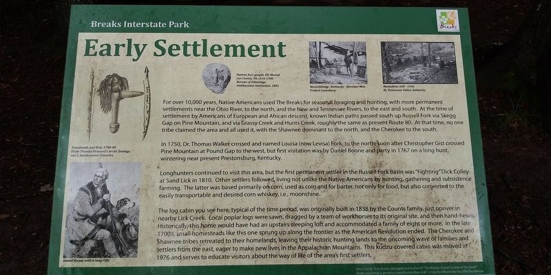
In 1750, Dr. Thomas Walker crossed and named Louisa (now Levisa) Fork, to the north: soon after Christopher Gist crossed Pine Mountain at Pound Gap to the west, but first visitation was by Daniel Boone and party in 1767 on a long hunt, wintering near present Prestonsburg, Kentucky.
Longhunters continued to visit this area, but the first permanent settler in the Russel Fork Basin was "Fighting" Dick Colley at Sand Lick in 1810. Other settlers followed, living not unlike the Native Americans by hunting, gathering and subsistence farming. The latter was based primarily on corn, used as coin and for barter, not only for food, but also converted to the easily transportable and desired corn whiskey, i.e., moonshine.
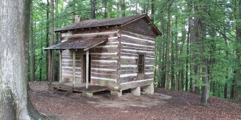
The log cabin you see here, typical of the time period, was originally built in 1838 by the Counts family, just upriver in nearby Lick Creek. Local poplar logs were sawn, dragged by a team of workhorses to its original site, and then hand-hewn. Historically, this home would have had an upstairs sleeping loft and accommodated a family of eight or more, In the late 1700's, small-homesteads like this one sprung up along the frontier as the American Revolution ended. The Cherokee and Shawnee tribes retreated to their homelands, leaving their historic hunting lands to the oncoming wave of families and settlers from the east, eager to make new lives in the Appalachian Mountains. This kudzu-covered cabin was moved in 1976 and serves to educate visitors about the way of life of the area's first settlers.
(captions)
Tomahawk and Bow, 1784-5 From Thomas Pennant's Artic Zoology, vol.1 , Smithsonian Libraries
Daniel Boone with long rifle
Human face gorget, Ely Mound Lee County, VA, circa 1300 Bureau of Ethnology, Smithsonian Institution, 1881
Moonshining - Kentucky - Revenue Man Project Gutenberg
Moonshine still - 1936 By Tennessee Valley Authority
Erected by Breaks Interstate Park.
Topics. This historical marker is listed in these topic lists: Native Americans • Parks & Recreational Areas • Settlements & Settlers. A significant historical year for this entry is 1750.
Location. 37° 17.233′ N, 82° 17.733′ W. Marker is near Breaks, Virginia, in Dickenson County. Marker can be reached from Commission Circle (Virginia Route 702) 0.6 miles west of Breaks Park Road (Virginia Route 80), on the right when traveling west. Touch for map. Marker is at or near this postal address: 627 Commission Circle, Haysi VA 24256, United States of America. Touch for directions.
Other nearby markers. At least 8 other markers are within 2 miles of this marker, measured as the crow flies. Salt Kettle (within shouting distance of this marker); Formation Of The Breaks (approx. 0.2 miles away); The Name Breaks (approx. 0.4 miles away); Mill Rock Point (approx. half a mile away); Mill Rock Point Overlook (approx. half a mile away); The Crooked Road (approx. half a mile away); Clinchfield Overlook (approx. half a mile away); Known But to God (approx. 1.2 miles away in Kentucky). Touch for a list and map of all markers in Breaks.
Credits. This page was last revised on June 28, 2023. It was originally submitted on November 26, 2020, by Craig Doda of Napoleon, Ohio. This page has been viewed 350 times since then and 56 times this year. Photos: 1, 2, 3. submitted on November 26, 2020, by Craig Doda of Napoleon, Ohio. • Bernard Fisher was the editor who published this page.


