Near Dune Acres in Porter County, Indiana — The American Midwest (Great Lakes)
Dune Creek Watershed: What Makes It Special?
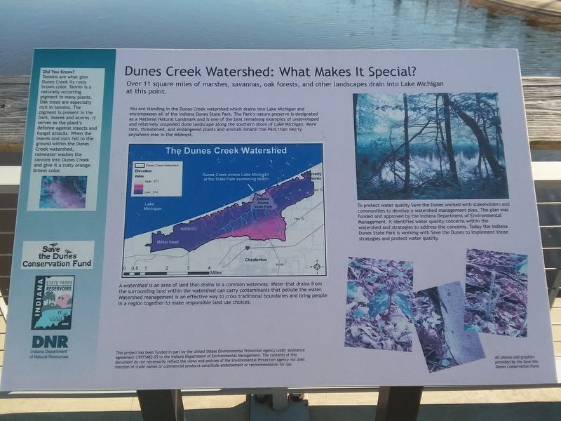
Photographed by Craig Doda, June 14, 2019
1. Dune Creek Watershed Marker
Over 11 square miles of marshes, savannas, oak forests, and other landscapes drain into Lake Michigan at this point.
You are standing in the Dunes Creek watershed which drains into Lake Michigan and encompasses all of the Indiana Dunes State Park. The Park's nature preserve is designated as a National Natural Landmark and is one of the best remaining examples of undeveloped and relatively unspoiled dune landscape along the southern shore of Lake Michigan. More rare, threatened, and endangered plants and animals inhabit the Park than nearly anywhere else in the Midwest.
A watershed is an area of land that drains to a common waterway. Water that drains from the surrounding land within the watershed can carry contaminants that pollute the water. Watershed management is an effective way to cross traditional boundaries and bring people in a region together to make responsible land use choices.
To protect water quality Save the Dunes worked with stakeholders and communities to develop a watershed management plan. The plan was funded and approved by the Indiana Department of Environmental Management. It identifies
this page online
Did You Know?
Tannins are what give Dunes Creek its rusty brown color. Tannin is a naturally occurring pigment in many plants. Oak trees are especially rich in tannins. The pigment is present in the bark, leaves and acorns. It serves as the plant's defense against insects and fungal attacks. When the leaves and nuts fall to the ground within the Dunes Creek watershed, rainwater washes the tannins into Dunes Creek and give it a rusty orange-brown color.
Erected by Indiana Department of Natural Resources.
Topics and series. This historical marker is listed in these topic lists: Charity & Public Work • Environment • Waterways & Vessels. In addition, it is included in the National Natural Landmarks series list.
Location. 41° 39.75′ N, 87° 3.767′ W. Marker is near Dune Acres, Indiana, in Porter County. It can be reached from County Road 25E 0.1 miles north of Indiana Dunes State Park Drive, on the right when traveling north. Touch for map. Marker is in this post office area: Chesterton IN 46304, United States of America. Touch for directions.

Regionally, this marker is in Northwest Indiana, specifically on the Indiana Dunes and Lake Michigan Shore, and in the Calumet Region. It is also in the American Midwest and in the Corn Belt. Globally, it is in North America, on the Great Lakes, in the Western Hemisphere, in the Western World, and in the Anglosphere. Historically, it finds itself in what was once the territory of the Mississippian Culture and also the Northwest Territory.
Other nearby markers. At least 8 other markers are within walking distance of this marker: "Squall Causes Lake Disaster" (here, next to this marker); The Wreck of the J.D. Marshall (a few steps from this marker); The Chicago Skyline (about 300 feet away, measured in a direct line); Le Petit Fort (about 600 feet away); Daylighting: Getting Dunes Creek Out of the Pipe (about 700 feet away); Mt. Tom: A View of Ancient Shorelines (approx. 0.3 miles away); Indiana State Parks: the First 100 Years 1916-2016 (approx. 0.4 miles away); Civilian Conservation Corps Flagpole (approx. 0.7 miles away).
Another marker is no longer nearby. The J.D. Marshall (was approx. 0.7 miles away but has been permanently removed).
Credits. This page was last revised on December 2, 2020. It was originally submitted on December 2, 2020, by Craig Doda of Napoleon, Ohio. This page has been viewed 470 times since then and 20 times this year. Photo 1. submitted on December 2, 2020, by Craig Doda of Napoleon, Ohio. • Devry Becker Jones was the editor who published this page.
