Yorktown in York County, Virginia — The American South (Mid-Atlantic)
Slabtown
Civil War Yorktown
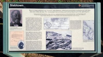
Testimony of Dr. Daniel Norton [McNorton], before a United States Congressional subcommittee on conditions in the South under reconstruction, February 3, 1866. Dr. Daniel Norton was a former slave, born in Williamsburg, Virginia who fled to the North and became a licensed physician. About 1864 he came to Yorktown to practice medicine, achieving prominence in Virginia politics and advocating education for previously enslaved Americans.
From May 1862 through the end of the Civil War, Yorktown was occupied by United States troops. Some enslaved Americans, who became known as “contraband of war," escaped from the Confederate controlled South and sought freedom behind the Federal lines at Yorktown. In July 1863, when Brigadier General Isaac J. Wistar was assigned command at Yorktown, he reported over 12,000 contraband were living off subsistence from his commissary. To provide them with shelter and an opportunity for self-sufficiency, he established housing on nearby land that was unoccupied by the owner. Wistar assigned his own troops to oversee the construction, reporting to his commanding officer, Major General John A. Dix, that he had “a large force at work laying out and erecting negro quarters...”
The new neighborhood became known as Slabtown, reflective of the pine wood slabs that the cabins were built from. Almost as soon as Slabtown was populated, the Friends’ Freedmen's Association of Philadelphia began sending teachers to establish schools in the community and a few businessmen to set up a store which provided supplies such as clothing, vegetable seeds, and farming tools. Army officers also arrived to recruit soldiers for the newly formed United States Colored Regiments.
After the war, Slabtown, sometimes called Uniontown, remained a vibrant community with a few businesses, school and church. However, ownership of the land reverted to its former Confederate owner. Not until the 1880s and 1890s did the inhabitants have the opportunity to purchase the property that some had lived on for many years. In the 1970s, the National Park Service, as part of an effort to restore more of Yorktown’s 1781 battlefield, purchased the Slabtown lots; and razed all the buildings. Some of the residents relocated less than a mile from their former homes.
(sidebar)
While Slabtown was constructed quickly, this 1867 military map of the community illustrates it was established with well surveyed streets and arrangement of buildings. Sergeant Charles Brooke of the 5th Michigan Cavalry description of Slabtown on March 5, 1864 confirms the planning that went into developing Slabtown: The streets are laid out regularly, about four roads wide. Each cabin is about twelve by eighteen feet, and one story high. They are all built of pine slabs, and the roofs are of the same. They each have an alley between, of four feet. Many are whitewashed and with neat fences round them. The interiors are generally neat and clean. The streets are kept swept, and every thing shows good discipline... These people have nearly all been slaves, and those that were born fee say that they were no better till our forces gained possession... They have their own stores, post-office,schools.. church...
(captions)
Dr. Daniel Norton, 1883 Courtesy of Virginia State University, of which Dr. Norton was a member of the university's first board of visitors.
General Issac Jones Wistar's General Order #13 directed tha From and after the 23d day of July...all negroes..be removed from within Fort Yorktown to the new quarters now being provided for them... Courtesy of the Wistar Intritute
This 1881 map shows a large decline in the number of homes and buildings in Slabtown; yet it also reveals a well defined community with almost as many structures as nearby Yorktown.
This 1924 aerial photograph shows Slabtown's roads and property lines (indicated by the perimeter of the fields) which reveal the planned and orderly nature of the community over 60 years after its establishment.
Erected by Colonial National Historical Park, National Park Servcice.
Topics and series. This historical marker is listed in these topic lists: African Americans • Settlements & Settlers • War, US Civil. In addition, it is included in the Historically Black Colleges and Universities series list. A significant historical year for this entry is 1863.
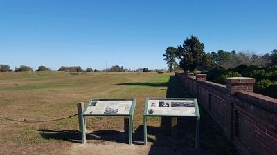
Location. 37° 13.555′ N, 76° 30.354′ W. Marker is in Yorktown, Virginia, in York County. Marker is on Cook Road (Virginia Route 238) north of Union Road, on the left when traveling south. Touch for map. Marker is in this post office area: Yorktown VA 23690, United States of America. Touch for directions.
Other nearby markers. At least 8 other markers are within walking distance of this marker. Shiloh Baptist Church (here, next to this marker); Second Allied Siege Line (within shouting distance of this marker); Surrender at Yorktown (within shouting distance of this marker); Yorktown National Cemetery (within shouting distance of this marker); a different marker also named Shiloh Baptist Church (about 400 feet away, measured in a direct line); Grand French Battery (approx. 0.2 miles away); a different marker also named The Grand French Battery (approx. 0.2 miles away); First Allied Siege Line (approx. 0.2 miles away). Touch for a list and map of all markers in Yorktown.
Also see . . . Yorktown Battlefield - Colonial National Historical Park. National Park Service (Submitted on November 26, 2015.)
Credits. This page was last revised on December 15, 2020. It was originally submitted on November 26, 2015, by Bernard Fisher of Richmond, Virginia. This page has been viewed 750 times since then and 89 times this year. Last updated on December 15, 2020, by Bradley Owen of Morgantown, West Virginia. Photos: 1, 2. submitted on November 26, 2015, by Bernard Fisher of Richmond, Virginia. • J. Makali Bruton was the editor who published this page.

