Near Crystal Springs in Stutsman County, North Dakota — The American Midwest (Upper Plains)
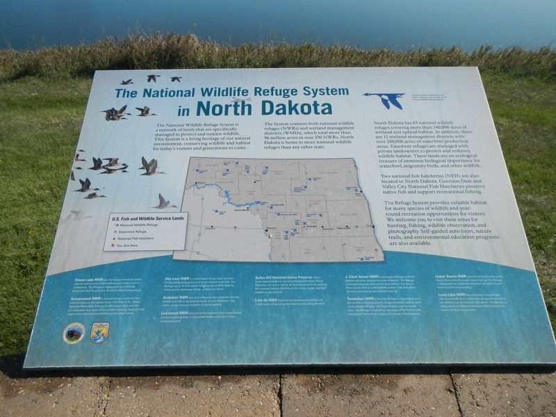
The National Wildlife Refuge System in North Dakota
Inscription.
The National Wildlife Refuge System is a network of lands that are specifically managed to protect and sustain wildlife. This System is a living heritage of our natural environment, conserving wildlife and habitat for today's visitors and generations to come.
The System contains both national wildlife refuges (NWRs) and wetland management districts (WMDs), which total more than 96 million areas over 550 NMRs. North Dakota is home to more national wildlife refuges than any other state.
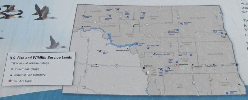
North Dakota has 63 national wildlife refuges covering more than 340,000 acres of wetland and upland habitat. In addition, there are 11 wetland management districts with over 280,000 acres of waterfowl production areas. Easement refuges are managed with private landowners to protect and enhance wildlife habitat. These lands are an ecological treasure of immense biological importance for waterfowl, migratory birds, and other wildlife.
Two national fish hatcheries (NFH) are also located in North Dakota. Garrison Dam and Valley City National Fish Hatcheries preserve native fish and support recreational fishing.
The Refuge System provides valuable habitat for many species of wildlife and year-round recreation opportunities for visitors. We welcome you to visit these areas for hunting, fishing, wildlife observation, and photography. Self-guide auto tours, nature trails, and environment education programs are also available.
Chase Lake NMR has the largest American white pelican colony in the United States and 4,155 acres of wilderness. The Refuge is designated as a Globally Important Bird Area by the American Bird Conservancy.
Arrowwood NWR is located along a series of four riverine lakes on the James River. The Historic Ft. Totten National Recreation Trail is a 9 mile nature trail, and the 5 1/2 mile auto tour route offers wildlife viewing opportunities. Learn more about prairie wildlife at the visitor center.
Des Lacs NWR is a great place to see large numbers of migrating snow geese and tundra swans in the fall. The Refuge has a 19-mile scenic backway for wildlife viewing in the prairie landscape along the Des Lacs River.
Audubon NWR has an 8-mile auto tour for viewing wildlife and offers panoramic views of Lake Audubon. The visitor center features exhibits of prairie wildlife.
Lostwood NWR has one of the highest known populations of sharp-tailed grouse in the United States and a 5,577 acre wilderness area.
Sullys Hill National Game Preserve NWR offers great opportunities to see and photograph bison, Rocky Mountain elk, and a variety of neotropical birds occupying the forested habitat. Exhibits at the visitor center highlight
wildlife on the prairies.
Lake Ilo NWR has cultural resourced showing over 11,000 years of use by prehistoric hunters and gathers.
J. Clark Salyer NWR is the largest Refuge in North Dakota and most diverse in terms of habitat. The Refuge is located along 45 miles of the South River. The South River Canoe Trail is a National Recreation Trail and offers 13 miles of canoeing and wild life viewing.
Tewaukon NWR is the only Refuge in North Dakota in the northern tall grass prairie. Unique butterfly species such as the Dakota Skipper and Regal Fritillary can be found here. The Refuge is located on the edge of the Central and Mississippi Flyways and has a rich variety of bird species.
Upper Souris NWR extends along 35 miles of the Souris River and offers year-round fishing. The Refuge is designated as a Globally Important Bird Area by the American Bird Conservancy.
Long Lake NWR has a diversity of waterfowl and shore birds and is nationally recognized as one of the nation's top ten birding "hot spots". The Refuge is designated as a Globally Important Bird Area but the American Bird Conservancy.
Erected by Department of the Interior, U.S Fish and Wildlife Service.
Topics. This historical marker is listed in these topic lists: Animals • Natural Features.
Location.
46° 52.5′ N, 99° 26.284′ W. Marker is near Crystal Springs, North Dakota, in Stutsman County. Marker can be reached from U.S. 94 at milepost 223 near 47th Avenue Southeast, on the right when traveling west. The marker is located at the Crystal Springs/St. Paul Rest Area Westbound. Touch for map. Marker is in this post office area: Medina ND 58467, United States of America. Touch for directions.
Other nearby markers. At least 6 other markers are within 14 miles of this marker, measured as the crow flies. Chase Lake NWR and the American White Pelican (about 400 feet away, measured in a direct line); Chase Lake Prairie Project (about 400 feet away); The Missouri Coteau - North America's Duck Factory. (about 400 feet away); Welcome to Crystal Springs WPA (about 400 feet away); Sibley Trail (approx. 12 miles away); Dr. J.S. Weiser (approx. 13.6 miles away).
Credits. This page was last revised on December 23, 2020. It was originally submitted on December 23, 2020, by Barry Swackhamer of Brentwood, California. This page has been viewed 317 times since then and 32 times this year. Photos: 1, 2, 3. submitted on December 23, 2020, by Barry Swackhamer of Brentwood, California.


