San José del Torreón in Ocampo, Guanajuato, Mexico — The Central Highlands (North America)
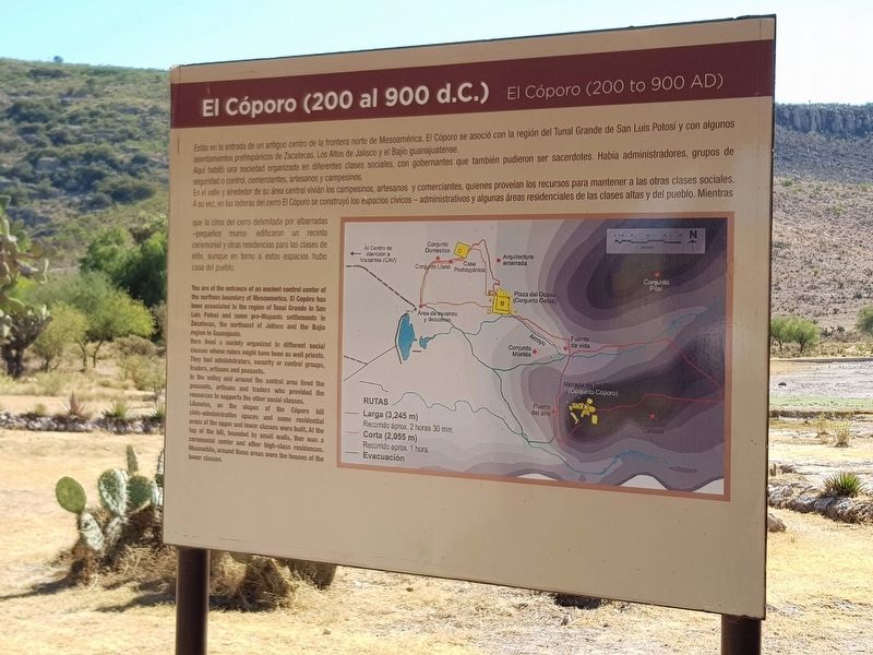
El Cóporo (200 to 900 AD)
Estás en la entrada de un antiguo centro de la frontera norte de Mesoamérica. El Cóporo se asoció con la región del Tunal Grande de San Luis Potosí y con algunos asentamientos prehispánicos de Zacatecas, Los Altos de Jalisco y el Bajio guanajuatense.
Aqui habitó una sociedad organizada en diferentes clases sociales, con gobernantes que también pudieron ser sacerdotes. Había administradores, grupos de seguridad o control, comerciantes, artesanos y campesinos.
En el valle y alrededor de su área central vivián los campesinos, artesanos y comerciantes, quienes proveían los recursos para mantener a las otras clases sociales. A su vez, en las laderas del cerro El Cóporo se construyó los espacios civicos-administrativos y algunas áreas residenciales de las clases altas y del pueblo. Mientras que la cima del cerro delimitada por albarradas - pequeños muros - edificaron un recinto ceremonial y otras residencias para las clases de elite, aunque en torno a estos espacios hubo casa del pueblo.
El Cóporo (200 to 900 AD)
You are at the entrance of an ancient control center of the northem boundary of Mesoamerica. El Copóro has been associated to the region of Tunal Grande in San Luis Potosi and some pre-Hispanic settlements in Zacatecas, the northeast of Jalisco and the Bajio region in Guanajuato.
Here lived a society organized in different social classes whose rulers might have been as well priests. They had administrators, security or control groups, traders, artisans and peasants.
In the valley and around the central area lived the peasants, artisans and traders who provided the resources to supports the other social classes.
Likewise, on the slopes of the Cóporo hill civic-administrative spaces and some residential areas of the upper and lower classes were built. At the top of the hill, bounded by small walls, ther was a ceremonial center and other high-class residences. Meanwhile, around these areas were the houses of the lower classes.
Erected by Instituto Nacional de Antropología e Historia (INAH).
Topics. This historical marker is listed in these topic lists: Anthropology & Archaeology • Native Americans • Parks & Recreational Areas.
Location. 21° 28.655′ N, 101° 27.723′ W. Marker is in San José del Torreón, Guanajuato, in Ocampo. Marker can be reached from Camino a El Cóporo, in the median. Touch for map. Marker is in this post office area: San José del Torreón GTO 37640, Mexico. Touch for directions.
Other nearby markers. At least 8 other markers are within 19 kilometers of this marker, measured as the crow flies. A City Under Cactus (about 150 meters away, measured in a direct line); The Pre-Hispanic House (approx. 0.2 kilometers away); The Kitchen (approx. 0.3 kilometers away); Sunset Square (approx. 0.3 kilometers away); The Sunset Room (approx. 0.3 kilometers away); The Transformation of the Landscape by Man (approx. 0.3 kilometers away); Father Hidalgo (approx. 19.1 kilometers away); Parish of San Juan Bautista (approx. 19.1 kilometers away). Touch for a list and map of all markers in San José del Torreón.
More about this marker. The El Cóporo Archaeological Site markers are accessible as part of a tour of the site. Access is during the site's normal hours of operation and a small fee is paid ($2 in 2020). The staff provides transportation to the site from the visitors center near San José del Torreón.
Credits. This page was last revised on December 31, 2020. It was originally submitted on December 31, 2020, by J. Makali Bruton of Accra, Ghana. This page has been viewed 83 times since then and 14 times this year. Photos: 1, 2, 3. submitted on December 31, 2020, by J. Makali Bruton of Accra, Ghana.


