Near Luray in Page County, Virginia — The American South (Mid-Atlantic)
Jackson’s 2nd Corps Established
Stonewall Dons a New Uniform

Photographed By Devry Becker Jones (CC0), October 31, 2020
1. Jackson’s 2nd Corps Established Marker
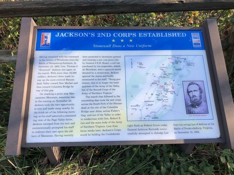
Having remained with his command in the vicinity of Winchester since the Battle of Sharpsburg/Antietam, by November 22, 1862, Gen. Thomas J. “Stonewall” Jackson was again on the march. With more than 32,000 soldiers, Jackson’s force made its way up the snow-covered Shenan doah Valley toward New Market and then toward Columbia Bridge by way of this gap.
On reaching a point atop Massanutten Mountain, sometime late in the evening on November 23, Jackson took the rare opportunity to rest and made camp nearby. In the brisk air of the following morning, as his staff admired a command ing view of the Page Valley below, Jackson emerged from his tent and unintentionally prompted his staff to redirect their awe upon the old hero of Manassas. Having recently been promoted to lieutenant general and wearing a new coat given him by General J.E.B. Stuart, a tall hat purchased by his mapmaker, Jedediah Hotchkiss, and a captured sword donated by a cavalryman, Jackson ignored the stares and boldly announced to his staff, “Young gentlemen, this is no longer the headquarters of the Army of the Valley, but of the Second Corps of the Army of Northern Virginia.”
The march that followed in the succeeding days took the new corps across the South Fork of the Shenandoah at the site of the Columbia Bridge near Alma, across Fisher’s Gap, and out of the Valley in order to rendezvous with Gen. Robert E. Lee and the main body of the Army of Northern Virginia. Less than three weeks later, Jackson’s Corps would be holding the Confederate right flank as Federal forces under General Ambrose Burnside unsuccessfully attempted to dislodge Lee from his strong line of defense at the Battle of Fredericksburg, Virginia on December 13, 1862.
Erected by Summers-Koontz Camp #490, SCV, with a grant made possible through the Shenandoah Valley Battlefields Foundation; Virginia Civil War Trails.
Topics and series. This historical marker is listed in this topic list: War, US Civil. In addition, it is included in the Sons of Confederate Veterans/United Confederate Veterans, and the Virginia Civil War Trails series lists. A significant historical month for this entry is November 1862.
Location. 38° 38.564′ N, 78° 36.674′ W. Marker is near Luray, Virginia, in Page County. Marker is on Lee Highway (U.S. 211) 0.1 miles west of Crisman Hollow Road, on the right when traveling east. Marker is at the George Washington National Forest Visitors Center at New Market Gap between Luray and New Market. Touch for map. Marker is at or near this postal address: 3210 Lee Hwy, Luray VA 22835, United States of America. Touch for directions.
Other nearby markers. At least 8 other markers are within walking distance of this marker. Massanutten Wildflower Trail (within shouting distance

Photographed By Devry Becker Jones (CC0), October 31, 2020
2. Jackson’s 2nd Corps Established Marker
Related markers. Click here for a list of markers that are related to this marker.
Credits. This page was last revised on July 8, 2021. It was originally submitted on December 23, 2006, by J. J. Prats of Powell, Ohio. This page has been viewed 2,648 times since then and 54 times this year. Last updated on February 25, 2009, by Robert H. Moore, II of Winchester, Virginia. Photos: 1, 2. submitted on November 1, 2020, by Devry Becker Jones of Washington, District of Columbia. • Craig Swain was the editor who published this page.