Near Preston in Franklin County, Idaho — The American West (Mountains)
Attack at Bia Ogoi
Massacre at Bear River
— The Largest Indian Massacre in the West —

Photographed By Barry Swackhamer, June 21, 2017
1. Attack at Bia Ogoi Marker
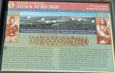
Caption: (panorama at top) 1. Ravine where Connor's troops came through; 2. Ford where troops crossed the Bear River; 3. Horse line; 4. Connor & Price Companies; 5. Shoshone Horse Herd; 6. Shoshone Camp; 7. Hoyt & McGarry's Cavalry.
Before dawn on the bitterly cold day of January 29, Shoshone leader Sagwich rose early to survey the area. As he looked toward the bluffs to the south he observed what seemed to be a mist of fog crawling down the bluffs across the river from the camp. Suddenly a company of soldiers on horseback appeared. The alarm was raised in the camp and the Shoshone leaders gathered to parley with the soldiers However, upon fording the river and seeing the mass of Shoshone, the cavalry opened fire and advanced on the camp. At first they were driven back and several soldiers were killed. Eventually, regrouping and reinforced by the infantry, the soldiers attacked the encampment and what began as a battle quickly became a massacre. The creek bottom where the Shoshone turned for protection, became instead a trap. Many who were not killed outright drowned while trying to escape in the river. The soldiers, better equipped with guns and ammunition, slaughtered the Indians in hand-to-hand combat. According to the Shoshone, Col. Connor never had any intention of negotiating with their people and arrived with the specific intention of attacking the Indians, leaving them no alternative but death and annihilation. (Marker Number 5.)
Topics. This historical marker is listed in these topic lists: Native Americans • Wars, US Indian. A significant historical date for this entry is January 29, 1863.
Location. 42° 9.16′ N, 111° 54.437′ W. Marker is near Preston, Idaho, in Franklin County. Marker is on U.S. 91 near Hot Springs Road. Touch for map. Marker is at or near this postal address: 2942 US Highway 91, Preston ID 83263, United States of America. Touch for directions.
Other nearby markers. At least 8 other markers are within walking distance of this marker. California Volunteers March to the Bear River (here, next to this marker); Change and Conflict (a few steps from this marker); Shoshone Bear River Winter Home (a few steps from this marker); A Battle Becomes a Massacre (a few steps from this marker); The Earth Will Remember (a few steps from this marker); The Shoshone (within shouting distance of this marker); Utah & Northern Railway (approx. 0.8 miles away); Bear River Massacre (approx. 0.8 miles away). Touch for a list and map of all markers in Preston.
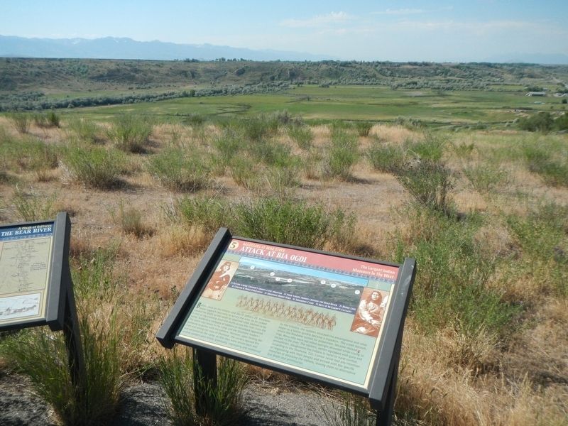
More about this marker. The Bear River Massacre Interpretive Site is located on a hilltop overlooking the site of the massacre.
Also see . . .
1. Patrick Connor and the Battle of Bear River. HistoryNet website entry:
Connor arrived in Utah Territory in 1862 with about 750 volunteer troops from California and Nevada. Disgruntled when he did not get reassigned to lead Union forces in Civil War battles, the disconsolate Connor established a permanent U.S. Army post at Camp Douglas (later called Fort Douglas), at the foot of the Wasatch Range overlooking Salt Lake City. Connor liked the location because, to soothe his bruised feelings from his unwelcome assignment, he could keep an eye on the activities of the Mormons. (Submitted on July 19, 2017, by Barry Swackhamer of Brentwood, California.)
2. Bear River Massacre. Wikipedia entry:
Brigham Young made the policy that Mormon settlers should establish friendly relations with the surrounding American Indian tribes. He encouraged their helping to "feed them rather than fight them". Despite the policy, the settlers were consuming significant food resources and taking over areas that pushed the Shoshone increasingly into areas of marginal food production. David II. Burr, Surveyor General of the Territory of Utah, reported in 1856 that the local Shoshone Indians complained that the Mormons used so much of the Cache Valley that the once abundant game no longer appeared. (Submitted on July 19, 2017, by Barry Swackhamer of Brentwood, California.)
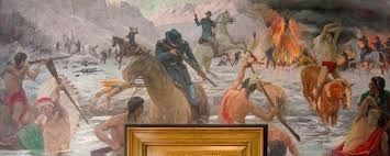
3. Indians at the Post Office, Native Themes in New Deal-Era Murals -- Smithsonian, Nat. Postal Museum. The Post Office in Preston, Idaho features a mural depicting one of the worst massacres of American Indian people in American history, the Bear River Massacre of 1863. Titled The Battle of Bear River, the mural was painted in 1941 by watercolor artist Edmond J. Fitzgerald... Fitzgerald’s
mural remains as a graphic reminder of some of the violence perpetrated against American Indians in the United States. (Submitted on July 19, 2017, by Barry Swackhamer of Brentwood, California.)
Credits. This page was last revised on November 30, 2021. It was originally submitted on July 18, 2017, by Barry Swackhamer of Brentwood, California. This page has been viewed 702 times since then and 40 times this year. Last updated on January 29, 2021, by Pete Skillman of Townsend, Delaware. Photos: 1, 2. submitted on July 18, 2017, by Barry Swackhamer of Brentwood, California. 3, 4. submitted on July 19, 2017, by Barry Swackhamer of Brentwood, California. • Bill Pfingsten was the editor who published this page.


