Searching for Slabtown
Unearthing Hampton's Grand Contraband Camp
What are we doing here?
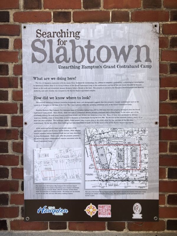
The City of Hampton contracted with the James River Institute for Archaeology, Inc. (JRIA) to complete a preliminary archaeological investigation to determine whether there is surviving evidence of the Grand Contraband Camp in the southwestern portion of this city block, bounded by Lincoln Street on the south and Armistead Avenue (formerly Liberty Street) to the west. The property is owned by the Hampton Redevelopment and Housing Authority, and until recently was occupied by the Harbor Square apartment complex.
How did we know where to look?
The available historical evidence (including documents, maps, and photographs) suggests that this property—largely undeveloped land on the outskirts of Hampton at the time of the Civil War—was included within the sprawling settlement area of the Grand Contraband Camp.
Detailed Sanborn Map Company fire insurance maps of Hampton dating from 1905 to 1956 show how this property developed after the Grand Contraband Camp period. Union Street, which now ends at Armistead Avenue, formerly continued east to King Street. In the latter part of the nineteenth century, the land along Lincoln and Union streets was divided into numerous urban lots. Many of these were purchased by African American families, some of whom likely
arrived in Hampton as Contrabands during the Civil War. By the turn of the twentieth century, nearly all of these lots were occupied. The buildings—mostly frame houses—were located close to the street, while the rear portions of the lots were undeveloped. By the late 1960s, these buildings had been demolished to make way for the construction of the Harbor Square apartments.After analyzing historic maps and modern plans of the apartment complex and its many buried utilities, JRIA selected several potential testing locations which had not been disturbed by later development. These areas offer the greatest potential for identifying intact archaeological remains associated with the Grand Contraband Camp.
[Captions:]
This detail of the 1956 Sanborn Map Company's fire insurance map of Hampton indicates the location of the testing area in relation to the former buildings and lots on Lincoln Street. Note the extension of Union Street, which now terminates at Armistead Avenue. The testing area was situated to avoid the late 19th- and early 20th-century building locations.
This plan of the former Harbor Square apartment complex indicates the location of the more recent buildings and utilities within the testing area. The slab foundations of the apartments have been buried in place.
Erected by
Topics. This historical marker is listed in these topic lists: African Americans • Anthropology & Archaeology • Settlements & Settlers • War, US Civil. A significant historical year for this entry is 1905.
Location. 37° 1.511′ N, 76° 20.806′ W. Marker is in Hampton, Virginia. It is in Downtown. Marker is at the intersection of Old Hampton Lane and History Museum Way, on the right when traveling west on Old Hampton Lane. Touch for map. Marker is at or near this postal address: 100 Old Hampton Ln, Hampton VA 23669, United States of America. Touch for directions.
Other nearby markers. At least 8 other markers are within walking distance of this marker. St. John's Church (within shouting distance of this marker); a different marker also named St. John's Church (within shouting distance of this marker); War of 1812 Veterans Interred or Memorialized in this Historic Cemetery (within shouting distance of this marker); Founders And Patriots Buried In This Cemetery (within shouting distance of this marker); a different marker also named St. John's Church (within shouting distance of this marker); a different marker also named St. John’s Church (within shouting distance of this marker); Hampton Confederate Monument (within shouting distance of this marker); Virginia Laydon (about 300 feet away, measured in a direct line). Touch for a list and map of all markers in Hampton.
Credits. This page was last revised on February 1, 2023. It was originally submitted on February 7, 2021, by Devry Becker Jones of Washington, District of Columbia. This page has been viewed 155 times since then and 21 times this year. Photos: 1, 2. submitted on February 7, 2021, by Devry Becker Jones of Washington, District of Columbia.

