
Triangle in Prince William County, Virginia — The American South (Mid-Atlantic)
Historic Preservation and Maintenance
Prince William Forest Park
| — | National Park Service, U.S. Department of the Interior | — |
Photographed by Devry Becker Jones (CC0), March 7, 2021
1. Historic Preservation and Maintenance Marker
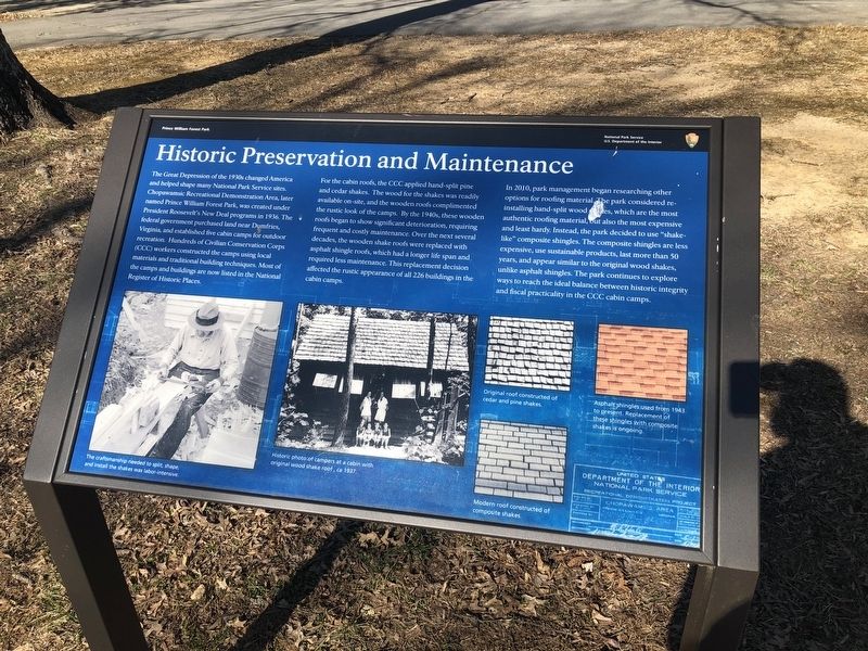
The Great Depression of the 1930s changed America and helped shape many National Park Service sites. Chopawamsic Recreational Demonstration Area, later named Prince William Forest Park, was created under President Roosevelt's New Deal programs in 1936. The federal government purchased land near Dumfries, Virginia, and established five cabin camps for outdoor recreation. Hundreds of Civilian Conservation Corps (CCC) workers constructed the camps using local materials and traditional building techniques. Most of the camps and buildings are now listed in the National Register of Historic Places.
For the cabin roofs, the CCC applied hand-split pine and cedar shakes. The wood for the shakes was readily available on-site, and the wooden roofs complimented the rustic look of the camps. By the 1940s, these wooden roofs began to show significant deterioration, requiring frequent and costly maintenance. Over the next several decades, the wooden shake roofs were replaced with asphalt shingle roofs, which had a longer life span and required less maintenance. This replacement decision affected the rustic appearance of all 226 buildings
this page online
In 2010, park management began researching other options for roofing material. The park considered reinstalling hand-split wood shakes, which are the most authentic roofing material, but also the most expensive and least hardy. Instead, the park decided to use "shake-like" composite shingles. The composite shingles are less expensive, use sustainable products, last more than 50 years, and appear similar to the original wood shakes, unlike asphalt shingles. The park continues to explore ways to reach the ideal balance between historic integrity and fiscal practicality in the CCC cabin camps.
Erected by National Park Service, U.S. Department of the Interior.
Topics and series. This historical marker is listed in these topic lists: Cemeteries & Burial Sites • Parks & Recreational Areas. In addition, it is included in the Civilian Conservation Corps (CCC) series list. A significant historical year for this entry is 1936.
Location. 38° 33.595′ N, 77° 20.841′ W. Marker is in Triangle, Virginia, in Prince William County. It is at the intersection of Telegraph Road and Park Entrance Road, on the right when traveling
Photographed by Devry Becker Jones (CC0), March 7, 2021
2. Historic Preservation and Maintenance Marker

Regionally, this marker is in the Washington Metropolitan Area, in Northern Virginia, and in the Piedmont. It is also in the American South, specifically in the Upper South, and in the Mid-Atlantic. Globally, it is in the North Atlantic Region, North America, the Western Hemisphere, the Western World, and the Anglosphere. Historically, it finds itself in what was once the territory of the Mississippian Culture, one of the original Thirteen Colonies, one of the Confederate States of America, and the Antebellum South.
Other nearby markers. At least 8 other markers are within walking distance of this marker: A Tradition of Conservation (here, next to this marker); Saplings of Hope (about 500 feet away, measured in a direct line); Almost Extinct (about 500 feet away); Piedmont Forest Trail (about 600 feet away); Flowering Dogwood (about 700 feet away); Eastern Red Cedar (about 700 feet away); Black Gum (about 700 feet away); Chestnut Oak (approx. 0.2 miles away). Touch for a list and map of all markers in Triangle.
Credits. This page was last revised on August 9, 2022. It was originally submitted on March 7, 2021, by Devry Becker Jones of Washington, District of Columbia. This page has been viewed 329 times since then and 16 times this year. Photos: 1, 2. submitted on March 7, 2021, by Devry Becker Jones of Washington, District of Columbia.
