Spy Run in Fort Wayne in Allen County, Indiana — The American Midwest (Great Lakes)
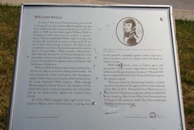
William Wells
A tract of 320 acres of land extending west of the St. Joseph River (the modern Bloomingdale and Spy Run neighborhoods) was set aside by an act of Congress in 1808 for the Indian agent William Wells in recognition of his many services to the U.S. government. This act established Well’s right to occupy and develop the land with an option to buy at $1.25 per acre (rather than having to bid for the land, as was usually the case) when the area was opened for sales by the U.S. Land Office. Wells created on these lands a farm that was worked by 12 African-Americans, who were held as slaves through life-time indentures, contrary to the prohibition against slavery declared in the Northwest Ordinance.
William Wells had been captured as a sixteen-year-old boy by Miami warriors raiding Kentucky. He was adopted by Chief Graviahatte (the Porcupine), taught Indian ways, and because of his red hair, given the name Apekonit (Wild Carrot). Wells married Manwangopath (Sweet Breeze), the daughter of war chief Little Turtle, and participated in the early battles led by his father-in-law against the United States forces.
In 1794, Wells changed sides and served Gen. Anthony Wayne as his “chief of spies,” or head scout, in the general’s campaign against Indian resistance, which reached a climax on August 20 at the Battle of Fallen timbers.
Wells had a stormy career as Indian agent and interpreter in the many negotiations between the Indians and the government; between 1796 and 1809 he accompanied Chief Little Turtle on his four trips to the nation’s capital.
Wells was killed by Potawatomi Indians in battle near Fort Dearborn (Chicago) in 1812 at the outbreak of the War of 1812. He had left Fort Wayne to try to lead the Fort Dearborn occupants, which included his niece, to safety. After he was killed, the Potawatomi ate his heart in the warriors’ belief that they would gain Wells’s renowned courage.
Topics. This historical marker is listed in these topic lists: Forts and Castles • Native Americans • War of 1812 • Wars, US Indian. A significant historical year for this entry is 1808.
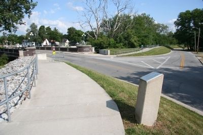
Location. 41° 5.362′ N, 85° 7.795′ W. Marker is in Fort Wayne, Indiana, in Allen County. It is in Spy Run. Marker is at the intersection of Tennessee Avenue and Griswold Drive, on the right when traveling west on Tennessee Avenue. This historical marker is located at the west end of the Tennessee Avenue Bridge over the St. Joseph River, in a residential neighborhood, about 0.4 miles north of the location where the St. Mary and St. Joseph Rivers come together to form the Maumee River. Touch for map. Marker is in this post office area: Fort Wayne IN 46805, United States of America. Touch for directions.
Other nearby markers. At least 8 other markers are
within walking distance of this marker. Meshekinnoquah (approx. 0.2 miles away); Chief Little Turtle (approx. 0.2 miles away); Civil War Memorial (approx. ¼ mile away); Site of Last French Fort (approx. ¼ mile away); The Headwaters of the Maumee River (approx. 0.4 miles away); Three Rivers Water Filtration Plant (approx. 0.4 miles away); a different marker also named Three Rivers Water Filtration Plant (approx. 0.4 miles away); The Battle of Kekionga (approx. half a mile away). Touch for a list and map of all markers in Fort Wayne.
Credits. This page was last revised on February 4, 2023. It was originally submitted on January 24, 2010, by Dale K. Benington of Toledo, Ohio. This page has been viewed 3,569 times since then and 59 times this year. Last updated on March 9, 2021, by Carl Gordon Moore Jr. of North East, Maryland. Photos: 1, 2. submitted on January 24, 2010, by Dale K. Benington of Toledo, Ohio. • Devry Becker Jones was the editor who published this page.

