Near Bolivar in Jefferson County, West Virginia — The American South (Appalachia)
Assessing the Obstacle
Harpers Ferry National Historical Park
— National Park Service, U.S. Department of the Interior —
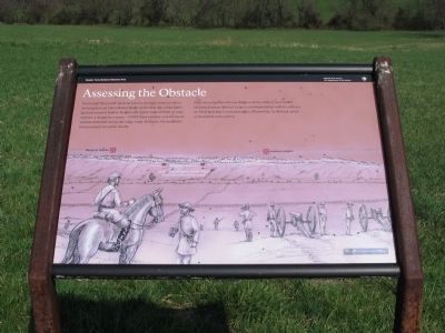
Never had "Stonewall" Jackson faced a stronger enemy position. Arriving here on Schoolhouse Ridge on the first day of the battle, Jackson scanned Bolivar Heights (the lower ridge in front of you) and saw a dangerous enemy - 7,000 Union infantry and dozens of cannon stretched across the ridge, ready for battle. He realized a frontal assault would be deadly.
After securing Schoolhouse Ridge with his artillery and 14,000 infantry, Jackson labored to open communications with his officers on Maryland and Loudoun heights. Meanwhile, he devised a plan of deception and surprise.
Erected by National Park Service, U.S. Department of the Interior.
Topics. This historical marker is listed in this topic list: War, US Civil.
Location. 39° 19.335′ N, 77° 46.71′ W. Marker is near Bolivar, West Virginia, in Jefferson County. Marker is on Bakerton Road (County Route 27), on the right when traveling south. Located in the north section of the School House Ridge unit of the Harpers Ferry National Historic Park. The marker is along a walking trail just north of the William L. Wilson Freeway (US 340). The trail is best reached from the parking area on Bakerton Road (CR 27). Touch for map. Marker is in this post office area: Harpers Ferry WV 25425, United States of America. Touch for directions.
Other nearby markers. At least 8 other markers are within walking distance of this marker. Confederates Converge (about 300 feet away, measured in a direct line); Destined for Antietam (about 500 feet away); Fake Attack - September 14th (about 700 feet away); No Man's Land (approx. 0.4 miles away); Flag Talk (approx. 0.4 miles away); Battle of Harpers Ferry (approx. 0.4 miles away); Allstadt House (approx. 0.6 miles away); A Dangerous Position (approx. 0.6 miles away). Touch for a list and map of all markers in Bolivar.
More about this marker. The background of the marker is a panoramic depiction of what Jackson's view of Bolivar Heights would have looked like on September 13, 1862. Confederate artillery stands in the foreground. In the background, Union soldiers prepare to defend Harpers Ferry from Confederate assault.
Also see . . . 1862 Battle of Harpers Ferry. National Park Service summary of the battle. (Submitted on May 21, 2008, by Craig Swain of Leesburg, Virginia.)

Photographed By Craig Swain, April 5, 2008
2. The Marker and Trail Wayside
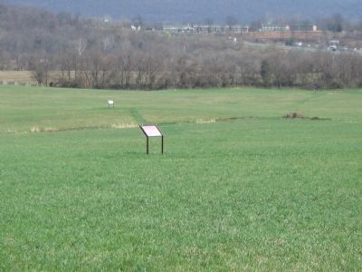
The Assessing the Obstacle marker stands along the trail, which is simply a mown section of the field at this point. The Confederates Converge and Fake Attack - September 14th markers are seen in the distance. Beyond the tree line on the right is US 340, bisecting Bolivar Heights.

Photographed By Craig Swain, April 5, 2008
3. Jackson's View of the Federal Positions
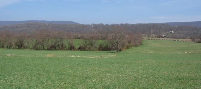
Looking at Bolivar Heights in a similar view to that represented on the marker. Bolivar Heights runs the full width of the photograph, on the other side of the fields and Bakerton Road. In the distant left is Maryland Heights, where McLaws' Confederates soon occupied a commanding position overlooking the town of Harpers Ferry. In the distant right is Loudoun Heights where Confederates under General Walker occupied similar positions overlooking the city.
Credits. This page was last revised on March 15, 2021. It was originally submitted on May 21, 2008, by Craig Swain of Leesburg, Virginia. This page has been viewed 1,321 times since then and 16 times this year. Last updated on March 14, 2021, by Bradley Owen of Morgantown, West Virginia. Photos: 1, 2, 3. submitted on May 21, 2008, by Craig Swain of Leesburg, Virginia. 4. submitted on March 14, 2021, by Bradley Owen of Morgantown, West Virginia. • Bill Pfingsten was the editor who published this page.

