Edgemoor near Wilmington in New Castle County, Delaware — The American Northeast (Mid-Atlantic)
Memories of Fox Point
The old days remembered
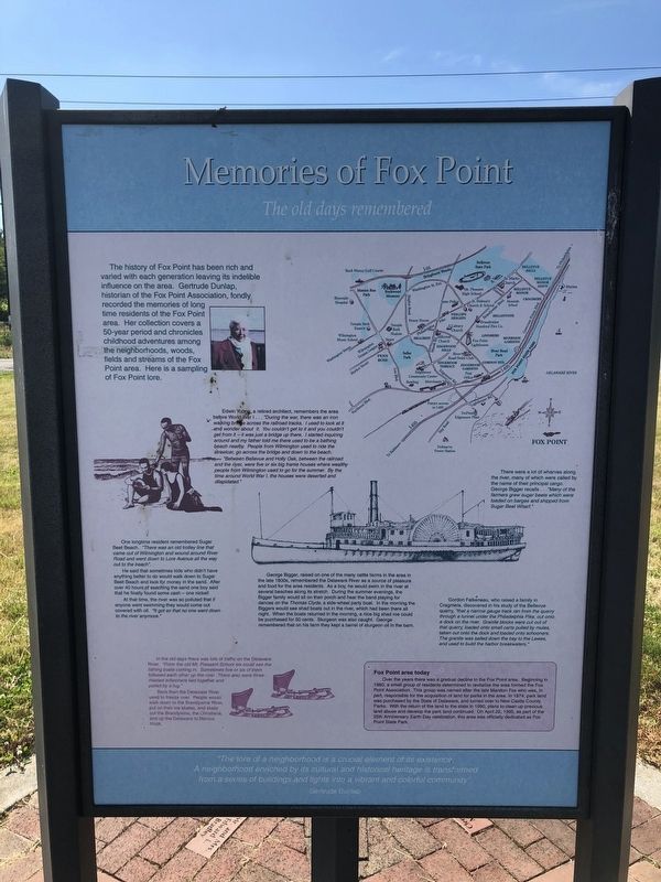
The history of Fox Point has been rich and varied with each generation leaving its indelible influence on the area. Gertrude Dunlap, historian of the Fox Point Association, fondly recorded the memories of long time residents of the Fox Point area. Her collection covers a 50-year period and chronicles childhood adventures among the neighborhoods, woods, fields and streams of the Fox Point area. Here is a sampling of Fox Point lore.
Edward Young, a retired architect, remembers the area before World War I … "During the war, there was an iron walking bridge across the railroad tracks. I used to look at it and wonder about it. You couldn't get to it and you couldn't get from it — it was just a bridge up there. I started inquiring around and my father told me there used to be a bathing beach nearby. People from Wilmington used to ride the streetcar, go across the bridge and down to the beach.
"Between Bellevue and Holly Oak, between the railroad and the river, were five or six big frame houses where wealthy wealthy people from Wilmington used to go for the summer. By the time around World War I, the houses were deserted and dilapidated."
There were a lot of wharves along the river, many of which were called by the name of their principal cargo. George Bigger recalls … "Many of the farmers grew sugar beets which were loaded on barges and shipped from Sugar Beet Wharf."
One longtime resident remembered Sugar Beet Beach. "There was an old trolley line that came out of Wilmington and wound around River Road and went down to Lore Avenue all the way out to the beach".
He said that sometimes kids who didn't have anything better to do would walk down to Sugar Beet Beach and look for money in the sand. After of 40 hours of searching the sand one boy said that he finally found some cash — one nickel!
At that time, the river was so polluted that if anyone went swimming they would come out covered with oil. "It got so that no one went down to the river anymore."
George Bigger, raised on one of the many cattle farms in the area in the late 1800s, remembered the Delaware River as a source of pleasure and food for the area residents. As a boy, he would swim in the river at several beaches along its stretch. During the summer evenings, the Bigger family would sit on their porch and hear the band playing for dances on the Thomas Clyde, a side-wheel party boat. In the morning the Biggers would see shad boats out in the river, which had been there all night. When the boats returned in the morning, a nice big shad roe could be purchased for 50 cents. Sturgeon was all caught. George remembered that on his farm they kept
Gordon Falkeneau, who raised a family in Cragmere, discovered in his study of the Bellevue quarry, "that a narrow gauge track ran from the quarry through a tunnel under the Philadelphia Pike, out onto a dock on the river. Granite blocks were cut out of that quarry, loaded onto small carts pulled by mules, taken out onto the dock and loaded onto schooners. The granite was sailed down the bay to the Lewes, and used to build the harbor breakwaters.
In the old days there was lots of traffic on the Delaware River. "From the old Mt. Pleasant School we could see the fishing boats coming in. Sometimes five or six of them followed each other up the river. There also were three-masted schooners tied together and pulled by a tug."
Back then, the Delaware River used to freeze over. People would walk down to the Brandywine River, put on their ice skates, and skate out the Brandywine, the Christiana, and up the Delaware to Marcus Hook.
Fox Point area today
Over the years there was a gradual decline in the Fox Point area. Beginning in 1980, a small group of residents determined to revitalize the area formed the Fox Point Association. This group was named after the late Marston Fox who was, in part, responsible for the acquisition of land for parks in the area. In 1974, park land was purchased
"The lore of a neighborhood is a crucial element of its existence. A neighborhood enriched by its cultural and historical heritage is transformed from a series of buildings and lights into a vibrant and colorful community".
Gertrude Dunlap
Topics and series. This historical marker is listed in these topic lists: Environment • Parks & Recreational Areas • Waterways & Vessels. In addition, it is included in the Delaware State Parks series list. A significant historical date for this entry is April 22, 1995.
Location. 39° 45.519′ N, 75° 29.308′ W. Marker is near Wilmington, Delaware, in New Castle County. It is in Edgemoor. Marker is on Lighthouse Road, 0.9 miles north of Ellerslie Road, on the right when traveling north. Touch for map. Marker is at or near this postal address: 1200 Lighthouse Rd, Wilmington DE 19809, United States of America. Touch for directions.
Other nearby markers. At least 8 other markers are within 2 miles of this marker, measured as the crow flies. Delaware: Trading with the world (within shouting distance of this marker); Welcome to Fox Point State Park
Credits. This page was last revised on April 7, 2023. It was originally submitted on June 1, 2021, by Devry Becker Jones of Washington, District of Columbia. This page has been viewed 505 times since then and 96 times this year. Last updated on February 10, 2022, by Carl Gordon Moore Jr. of North East, Maryland. Photos: 1, 2, 3, 4. submitted on June 1, 2021, by Devry Becker Jones of Washington, District of Columbia. • J. Makali Bruton was the editor who published this page.


