Of By For
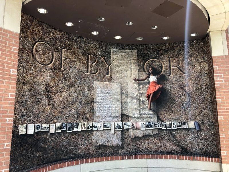
[The marker features a set of panels that are sections of a mural:]
European map of this geographic area, attributed to John Smith, 1608. People lived here for ten thousand years or more before the European invasion.
Thereupon [the Peacemaker] stood up in the center of the gathering place, and said, "Fist I will answer what I mean when I say, 'It is arriving, the Good Message.' This means it will stop the slaughter of your own people who live here on earth, then everywhere peace will come about, by day and by night. And it will come that as one travels about, everyone will be related. Then, indeed, they will not be in danger in the future.Second, when I say, 'Now it is arriving, the Power,' this means that the different nations, all of them, will become just a single one, and the Great Law will come into being, so that now, all will be related to each other, and there will come to be just a single family, and this family will continue on in the days ahead.
Now, my third saying, 'Now it is arriving, The Peace,' this means that everyone will become related, men, women and children, and when all are relatives, every nation, there will be peace… There will be truthfulness, and they will uphold hope and charity, so that peace will unite all of the people, indeed, it will be as though that
have but one mind/thought, and they have one head, and they have one life…-- translation of a fragment of Gayanashagowa, the ancient Great Law of Peace of the Haudenosaunee (Iroquois)
This region was once protected by the Covenant Chain, a formal alliance of colonists and the Iroquois Confederacy. Gayanashagowa influenced American concepts of individual rights and political unity.
General Edward Braddock led British troops and artillery along this road in 1755. He underestimated his Indian foes and was defeated.
The ancient Sinequa Trail ran past this spot. The trail became the Rolling Road, where planters, tenants and slaves rolled hogsheads of tobacco south to the ports. Eventually the trail/road became North Washington Street.
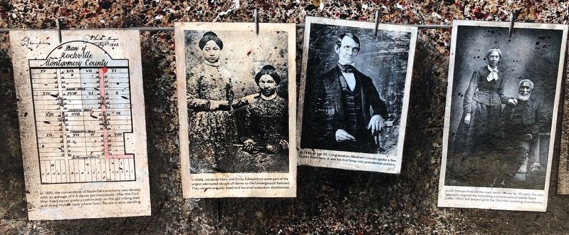
In 1800, the cornerstone of Rockville's economy was slavery with an average of 4-6 slaves per household. After the Civil War, freed slaves made a community on the old rolling road along Middle Lane where Town Square is now standing.
In 1848, residents Mary and Emily Edmonson were part of the largest attempted escape of slaves on the Underground Railroad. They were eventually freed and became outspoken abolitionists.
In 1848, at age 39, Congressman Abraham Lincoln spoke a few blocks from here: it was his first foray into presidential politics.
Josiah Henson lived on this road, south of
1850: the Edmonson sisters & Frederick Douglass at the Fugitive Slave Convention in New York, which declared slaves POWs and nominated William chaplin for President - the abolitionist was in jail in Rockville for aiding slaves.
One Hundred Dollars Reward.—Ran away from the subscriber living in Rockville, Montgomery county, Md., on Saturday 31st of May last,
Negro Man, Alfred. about twenty-two years of age; five feet seven inches high; dark copper color, and rather good looking.I will give the above reward if taken out of the county, and in any of the States, or fifty dollars if taken in the county or the District of Columbia, and secured so that I get him again.
John W. Anderson.
j6-1wW2.
Her brothers were sold South, but 12 year old Ann Maria Weems escaped slavery in Rockville with the help of a daring, biracial network of freedom workers and abolitionists.
John H. Higgins, a town commissioner of Rockville and a Unionist, was captured by Jeb Stuart's Confederate forces. Pro-Southern Rockville
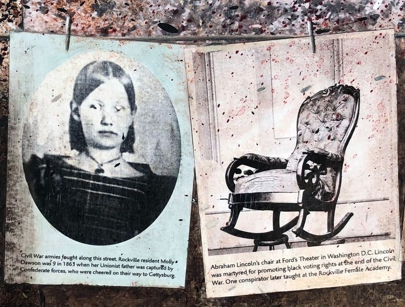
Civil War armies fought along this street. Rockville resident Molly Dawson was 9 in 1863 when her Unionist father was captured by Confederate forces, who were cheered on their way to Gettysburg.
Abraham Lincoln's chair at Ford's Theater in Washington D.C. Lincoln was martyred for promoting black rights at the end of the Civil War. One conspirator later taught at the Rockville Female Academy.
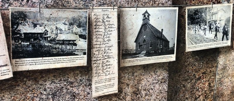
Freed slaves faced violence and extreme poverty. They built shanties on the unwanted marshy land located out of the frame to the left of this undated photo. They created their own churches, schools and culture, all centered around the exact spot where you now stand.
The "X" marks of illiterate Rockville freedmen on an 1867 pledge to pay for a school for their children.
Opposition to black education was widespread and bitter in Maryland; teachers were stoned and schoolhouses burned.
The church played a key role during the enslavement. Clinton Zion A.M.E. Church was founded by free blacks at the close of the Civil War in 1867. They acquired this building on the southwest corner of this intersection, in 1904.
Members of Rockville's black band and baseball team march on unpaved Washington Street circa 1910. This annual Decoration Day celebration was the beginning of the city's Memorial Day parade tradition.
Emma
224 N. Washington Street
Rockville, MD
Emma Sedgwick, my mother's guardian. Raised her from infancy. Like my mother's mother, the only mother mamma ever knew.
Mandie
In 1912, blacks founded Fisherman's Hall across the street from this spot, providing social, cultural, and other opportunities that were denied them. Students crowded in for years after the black the black school on this street burned.
The 30 Club, founded in 1930, gathers across the street, in front of Fisherman's Hall. The herringbone brick sidewalk at the entrance is worn from constant foot traffic.
The first graduating class of the Rockville Colored High School in 1931 with the bus their parents funded to bring them to their school at this intersection - a daily trip of hours. Integration of schools began in 1955.
Lincoln referred to this nation's "new birth of freedom." He meant the equality of all people. He meant black freedom.
In 1936 the principal of the elementary school on this went to court to fight for equal pay for black teachers. Black homeowners in Rockville pledged their homes as collateral in support. The case led to equal pay in nine Maryland counties, but principal William B. Gibbs, Jr., was fired.
William B. Gibbs, Jr. was represented in court by Thurgood Marshall.
Stop! Weare asking your support in an effort to bring real democracy to Rockville.Rockville has won an award as an All-American City. We are proud of this award. We know you are.
This store will not serve all of its customers at its food counters will you help us to change this policy and make this truly an All-American City, a wonderful place in which to live.
Shop at stores like Murphy's that serve everyone alike.
Montgomery Civic Unity Committee
V.F.W. Post 9863
NAACP Rockville BranchPlease fill out the blank below and return to
the person who gave you this flyer or
Major ancestry groups reported by Rockville residents include:
German - 11%
Irish - 10%
Black or African American - 9%
English - 8%
Chinese, except Taiwanese - 6%
Other Hispanic or Latino - 4%
Russian - 4%
Italian - 4%
Central American - 3%
Polish - 3%
South American: - 2%
Asian Indian - 2%
Salvadoran - 2%
Korean - 2%
Scottish - 2%
French (except Basque) - 2%
Iranian - 2%
Scotch-Irish - 2%
European - 2%
Filipino - 1%
Japanese - 1%
Subsaharan African - 1%
West Indian - 1%
Mexican - 1%
British - 1%
Eastern European - 1%
Arab - 1%
Israeli - 1%
Vietnamese- 1%
Swedish - 1%
Peruvian - 1%
Norwegian - 1%
Welsh - 1%
Greek - 1%
Ukrainian - 1%
Dutch - 1%
Jamaican - 1%
Hungarian - 1%
French Canadian - 1%
Austrian - 1%
Topics and series. This historical marker is listed in these topic lists: African Americans • Churches & Religion • Colonial Era • War, US Civil. In addition, it is included in the African Methodist Episcopal Zion (AME Zion) Church, and the Former U.S. Presidents: #16 Abraham Lincoln series lists. A significant historical year for this entry is 1608.
Location. 39° 5.207′ N, 77° 9.17′ W. Marker is in Rockville, Maryland, in Montgomery County. Marker is at the intersection of North Washington Street and Beall Avenue, on the right when traveling north on North Washington Street. Touch for map. Marker is at or near this postal address: 255 N Washington St, Rockville MD 20850, United States of America. Touch for directions.
Other nearby markers. At least 8 other markers are within walking distance of this marker. Clinton A.M.E. Zion Church (a few steps from this marker); Mr. T's (within shouting distance of this marker); Rockville's First Colored School / Rockville's Second Colored School (within shouting distance of this marker); Rockville Town Square (within shouting distance of this marker); Galilean Temple (about 300 feet away, measured in a direct line); Snowden Funeral Home (about 400 feet away); Hebron House and Print Shop (about 400 feet away); Jerusalem - Mt. Pleasant Church and Parsonage (about 400 feet away). Touch for a list and map of all markers in Rockville.
Credits. This page was last revised on June 6, 2021. It was originally submitted on June 6, 2021, by Devry Becker Jones of Washington, District of Columbia. This page has been viewed 152 times since then and 13 times this year. Photos: 1, 2, 3, 4, 5, 6. submitted on June 6, 2021, by Devry Becker Jones of Washington, District of Columbia.


