Transportation
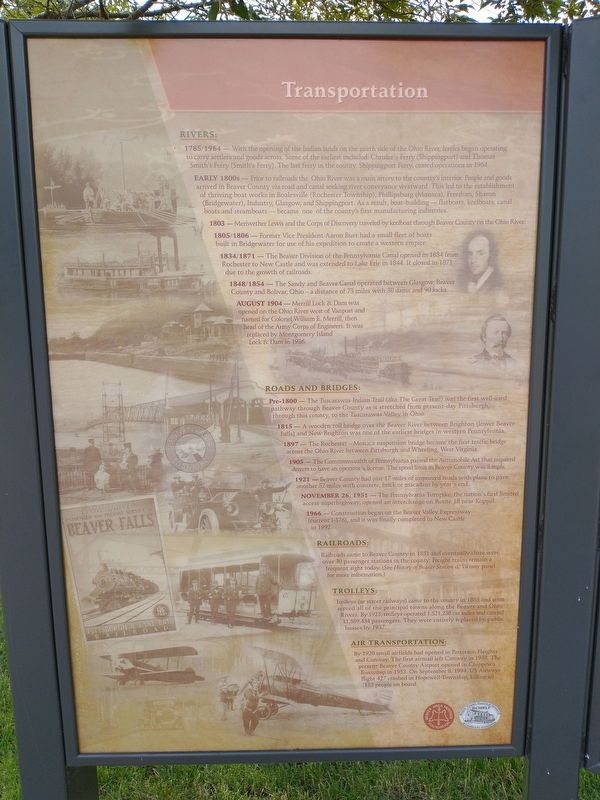
1785/1964 - With the opening of the Indian lands on the north side of the Ohio River, ferries began operating to carry settlers and goods across. Some of the earliest included: Chrisler's Ferry (Shippingport) and Thomas Smith's Ferry (Smith's Ferry). The last ferry in the county, Shippingport Ferry, ceased operations in 1964.
Early 1800s - Prior to railroads the Ohio River was a main artery to the country's interior. People and goods arrived in Beaver County via road and canal seeking river conveyance westward. This led to the establishment of thriving boat works in Boalesville (Rochester Township), Phillipsburg (Monaca), Freedom, Sharon (Bridgewater), Industry, Glasgow, and Shippingport. As a result, boat-building -flatboats, keelboats, canal boats and steamboats -became one of the county's first manufacturing industries.
1803 – Meriwether Lewis and the Corps of Discovery traveled by keelboat through Beaver County on the Ohio River.
1805/1806 - Former Vice President Aaron Burr had a small fleet of boats built in Bridgewater for use of his expedition to create a western empire.
1834/1871 - The Beaver Division of the Pennsylvania Canal opened in 1834 from Rochester to New Castle and was extended to Lake Erie in 1844. It closed in 1871 due to the growth of railroads.
1848/1854
- The Sandy and Beaver Canal operated between Glasgow, Beaver County and Bolivar, Ohio – a distance of 73 miles with 30 dams and 90 locks.August 1904 - Merrill Lock & Dam was opened on the Ohio River west of Vanport and named for Colonel William E. Merrill, then head of the Army Corps of Engineers. It was replaced by Montgomery Island Lock & Dam in 1936.
Roads And Bridges:
Pre-1800 - The Tuscarawas Indian Trail (aka The Great Trail) was the first well-used pathway through Beaver County as it stretched from present-day Pittsburgh, through this county, to the Tuscarawas Valley in Ohio.
1815 - A wooden toll bridge over the Beaver River between Brighton (lower Beaver Falls) and New Brighton was one of the earliest bridges in western Pennsylvania.
1897 - The Rochester – Monaca suspension bridge became the first traffic bridge across the Ohio River between Pittsburgh and Wheeling, West Virginia.
1905 - The Commonwealth of Pennsylvania passed the Automobile Act that required drivers to have an operator's license. The speed limit in Beaver County was 8 mph.
1921 - Beaver County had just 17 miles of improved roads with plans to pave another 52 miles with concrete, brick or macadam by year's end.
November 26, 1951 - The Pennsylvania Turnpike, the nation's first limited access superhighway, opened an interchange on Route
18 near Koppel. 1966 Construction began on the Beaver Valley Expressway (current I-376), and it was finally completed to New Castle in 1992.Railroads:
Railroads came to Beaver County in 1851 and eventually there were over 30 passenger stations in the county. Freight trains remain a frequent sight today. (See History of Beaver Station & Vicinity panel for more information.)
Trolleys:
Trolleys (or street railways) came to the county in 1885 and soon served all of the principal towns along the Beaver and Ohio Rivers. By 1925, trolleys operated 1,521,238 car miles and carried 11,589,454 passengers. They were entirely replaced by public busses by 1937.
Air Transportation:
By 1920 small airfields had opened in Patterson Heights
and Conway. The first airmail left Conway in 1938. The
present Beaver County Airport opened in Chippewa
Township in 1953. On September 8, 1994, US Airways
flight 427 crashed in Hopewell Township, killing all
132 people on board.
Topics. This historical marker is listed in these topic lists: Air & Space • Railroads & Streetcars • Roads & Vehicles • Waterways & Vessels.
Location. 40° 41.879′ N, 80° 17.83′ W. Marker is in Beaver, Pennsylvania, in Beaver County. Marker is on East
Other nearby markers. At least 8 other markers are within walking distance of this marker. Properties On The National Register of Historic Places (here, next to this marker); Beaver County Firsts (a few steps from this marker); Women in Beaver County (a few steps from this marker); Beaver County National Firsts (a few steps from this marker); African Americans (a few steps from this marker); Famous Athletes (a few steps from this marker); Military Service (a few steps from this marker); Big Industry Brings Progress 1901-1917 (a few steps from this marker). Touch for a list and map of all markers in Beaver.
Credits. This page was last revised on July 15, 2021. It was originally submitted on July 11, 2021, by Craig Doda of Napoleon, Ohio. This page has been viewed 111 times since then and 9 times this year. Photos: 1, 2. submitted on July 11, 2021, by Craig Doda of Napoleon, Ohio. • Bill Pfingsten was the editor who published this page.

