Near Lake City in Hinsdale County, Colorado — The American Mountains (Southwest)
Ute Homeland
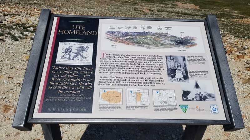
The Ute Indians who inhabited what is now Colorado, Utah, and northern New Mexico were organized into small family bands. They migrated seasonally between the mountains and the deserts and foothills in search of game and wild plants and to rendezvous with other Ute bands. With the discovery of gold in the San Juan Mountains in the 1860s, prospectors knowingly trespassed on Ute land to stake mining claims. As more settlers arrived, the Utes lost most of their traditional homeland in a series of agreements and treaties with the U.S. Government.
Ute elder, Chief Ouray, saw that his people would not be able to withstand the onslaught of new settlers. He negotiated the Brunot Treaty in 1873 that allowed miners and settlers to occupy the former Ute homeland in the San Juan Mountains.
Captions
1. "Either they (the Utes) or we must go, and we are not going ... the Western Empire is an inexorable fact. He who gets in the way of it will be crushed.
-The Denver Times, 1879 (This reflected the prevailing attitudes toward the Utes by Euro-Americau settlers.)
2. The original Ute homeland included traditional hunting grounds in what is now Colorado, Utah, southern Wyoming, and northern New Mexico.
3. The Ute reservation established under the Ute Treaty of 1863 and the Brunot Treaty in 1873.
4. Current Ute reservations were established under the Washington Treaty of 1879 and a division between the Ute Mountain and Southern Ute reservation in 1895.
5. Chief Ouray and his wife Chipeta. Ouray worked hard to keep peace between his people and the settlers that entered the Ute homeland.
-Photo courtesy of Denver Public Library
6. The use of tepees and brush wickiups allowed the nomadic Utes to migrate with the seasons.
-Photo courtesy of Denver Public Library
Erected by U.S. Department of the Interior - Alpine Loop.
Topics. This historical marker is listed in these topic lists: Exploration • Native Americans • Parks & Recreational Areas • Wars, US Indian. A significant historical year for this entry is 1873.
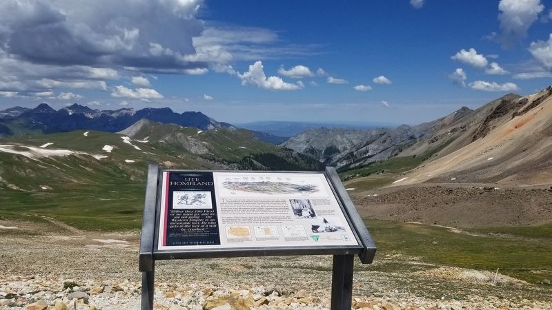
Location. 37° 58.456′ N, 107° 35.12′ W. Marker is near Lake City, Colorado, in Hinsdale County. Marker is at the intersection of County Highway 2 and County Highway 20, on the left when traveling north on County Highway 2. The marker is located at the top of Engineer Pass on the Alpine Loop. Touch for map. Marker is in this post office area: Lake City CO 81235, United States of America. Touch for directions.
Other nearby markers. At least 8 other markers are within 6 miles of this marker, measured as the crow flies. The William Duncan House (approx. 3 miles away); Animas Forks (approx. 3.1 miles away); Bonanza Empire Chief (approx. 3.4 miles away); White Death (approx. 3.4 miles away); This Marker in Memory of Rev. Marvin Hudson (approx. 4.1 miles away); Rose Lime Kiln (approx. 4.8 miles away); Tellurium or Was It Whitecross (approx. 5.4 miles away); A Town with Three Names (approx. 5.4 miles away). Touch for a list and map of all markers in Lake City.
Regarding Ute Homeland. The road to Engineer Pass is a rugged 4x4 road and requires a tough 4x4 vehicle to handle the off road and rocky conditions.
Also see . . .
1. Alpine Loop.
The Alpine Loop is truly a backcountry experience. Make sure someone knows your travel plans and do your homework before you start your trip. Make sure you have plenty of water, food and fuel to make it to your destination. Electronics and wireless devises DO NOT work in most places on the Alpine Loop. It is recommended that you download or print hard copy maps prior to your trip. The Alpine Loop Backcountry Byway is a rugged 4x4 road that winds through the spectacular scenery of the San Juan Mountains, connecting Lake City, Silverton, and Ouray. The Alpine Loop byway traverses passes up to 12,800 feet while showcasing old mines, ghost towns, natural wonders, beautiful wildflowers, and abundant wildlife. Alpine Loop is an avenue for exploring nature and history amidst thrilling views and stunning geography. Tackling the loop in its entirety is easily an all-day experience event. However, the main loop is only part of the experience; miles of designated side routes allow visitors to either take a short tour or extend their trip to multiple days. For more information, please contact the Gunnison Field Office.(Submitted on July 23, 2021, by James Hulse of Medina, Texas.)
2. Southern Ute Indian Tribe History.
The Ute people are the oldest residents of Colorado, inhabiting the mountains and vast areas of Colorado, Utah, Wyoming, Eastern Nevada, Northern New Mexico and Arizona. According to tribal history handed down from generation to generation, our people lived here since the beginning of time. Prior to acquiring the horse, the Utes lived off the land establishing a unique relationship with the ecosystem. They would travel and camp in familiar sites and use well established routes such as the Ute Trail that can still be seen in the forests of the Grand Mesa, and the forerunner of the scenic highway traversing through South Park, and Cascade, Colorado. Source: Southern Ute Indian Tribe(Submitted on July 23, 2021, by James Hulse of Medina, Texas.)
Credits. This page was last revised on July 24, 2021. It was originally submitted on July 23, 2021, by James Hulse of Medina, Texas. This page has been viewed 294 times since then and 42 times this year. Photos: 1, 2, 3, 4, 5. submitted on July 23, 2021, by James Hulse of Medina, Texas.


