Milton in Northumberland County, Pennsylvania — The American Northeast (Mid-Atlantic)
The Founding of Milton
Limestone Run / The Founding of Milton
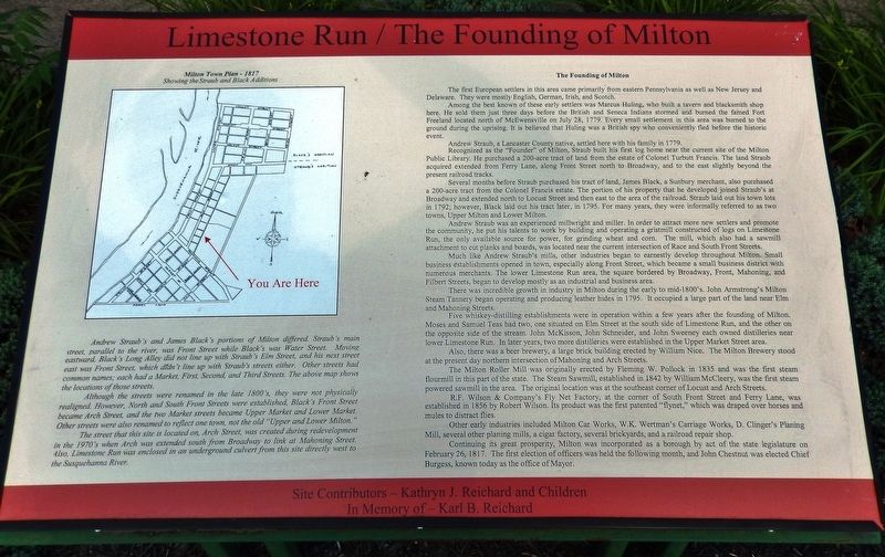
The first European settlers in this area came primarily from eastern Pennsylvania as well as New Jersey and Delaware. They were mostly English, German, Irish, and Scotch.
Among the best known of these early settlers was Marcus Huling, who built a tavern and blacksmith shop here. He sold them just three days before the British and Seneca Indians stormed and burned the famed Fort Freeland located north of McEwensville on July 28, 1779. Every small settlement in this area was burned to the ground during the uprising. It is believed that Huling was a British spy who conveniently fled before the historic event.
Andrew Straub, a Lancaster County native, settled here with his family in 1779. Recognized as the "Founder" of Milton, Straub built his first log home near the current site of the Milton Public Library. He purchased a 200-acre tract of land from the estate of Colonel Turbutt Francis. The land Straub acquired extended from Ferry Lane, along Front Street north to Broadway, and to the east slightly beyond the present railroad tracks.
Several months before Straub purchased his tract of land, James Black, a Sunbury merchant, also purchased a 200-acre tract from the Colonel Francis estate. The portion of his property that he developed joined Straub's at Broadway and extended north to Locust Street and then east to the area of the railroad. Straub laid out his town lots in 1792; however, Black laid out his tract later, in 1795. For many years, they were informally referred to as two towns, Upper Milton and Lower Milton.
Andrew Straub was an experienced millwright and miller. In order to attract more new settlers and promote the community, he put his talents to work by building and operating a gristmill constructed of logs on Limestone Run, the only available source for power, for grinding wheat and corn. The mill, which also had a sawmill attachment to cut planks and boards, was located near the current intersection of Race and South Front Streets.
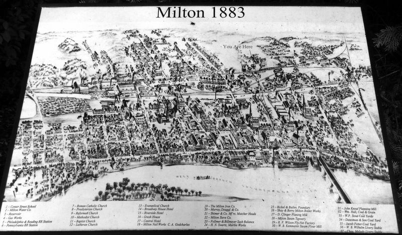
Much like Andrew Straub's mills, other industries began to earnestly develop throughout Milton. Small business establishments opened in town, especially along Front Street, which became a small business district with numerous merchants. The lower Limestone Run area, the square bordered by Broadway, Front, Mahoning, and Filbert Streets, began to develop mostly as an industrial and business area.
There was incredible growth in industry in Milton during the early to mid-1800's. John Armstrong's Milton Steam Tannery began operating and producing leather hides in 1795. It occupied a large part of the land near Elm and Mahoning Streets.
Five whiskey-distilling establishments were in operation within a few years after
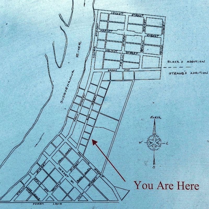
2. Marker detail: Milton Town Plan — 1817
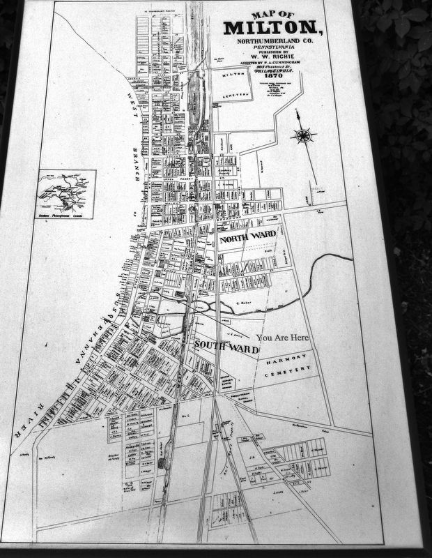
Although the streets were renamed in the late 1800's, they were not physically realigned. However, North and South Front Streets were established, Black's Front Street became Arch Street, and the two Market streets became Upper Market and Lower Market. Other streets were also renamed to reflect one town, not the old "Upper and Lower Milton."
The street that this site is located on, Arch Street, was created during redevelopment in the 1970's when Arch was extended south from Broadway to link at Mahoning Street. Also, Limestone Run was enclosed in an underground culvert from this site directly west to the Susquehanna River.
Also, there was a beer brewery, a large brick building erected by William Nice. The Milton Brewery stood at the present day northern intersection of Mahoning and Arch Streets.
The Milton Roller Mill was originally erected by Fleming W. Pollock in 1835 and was the first steam flourmill in this part of the state. The Steam Sawmill, established in 1842 by William McCleery, was the first steam powered sawmill in the area. The original location was at the southeast corner of Locust and Arch Streets.
R.F. Wilson & Company's Fly Net Factory, at the corner of South Front Street and Ferry Lane, was established in 1856 by Robert Wilson. Its product was the first patented "flynet," which was draped over horses and mules to distract flies.
Other early industries included Milton Car Works, W.K. Wertman's Carriage Works, D. Clinger's Planing Mill, several other planing mills, a cigar factory, several brickyards, and a railroad repair shop.
Continuing its great prosperity, Milton was incorporated as a borough
by act of the state legislature on February 26, 1817. The first election of officers was held the following month, and John Chestnut was elected Chief Burgess, known today as the office of Mayor.
Erected by Milton Historic Downtown Walking Tour.
Topics. This historical marker is listed in these topic lists: Industry & Commerce • Native Americans • Roads & Vehicles • Settlements & Settlers.
Location. 41° 1.032′ N, 76° 51.271′ W. Marker is in Milton, Pennsylvania, in Northumberland County. Marker is on Arch Street (Pennsylvania Route 405) north of Race Street, on the right when traveling north. Marker is located in a small pedestrian plaza beside the sidewalk, near Limestone Run. Touch for map. Marker is in this post office area: Milton PA 17847, United States of America. Touch for directions.
Other nearby markers. At least 8 other markers are within walking distance of this marker. The West Branch of the Pennsylvania Canal System (here, next to this marker); Samuel J. Shimer & Sons / Milton Manufacturing Co. (about 500 feet away, measured in a direct line); Chef Boy-Ar-Dee (about 500 feet away); Milton Car Works / ACF Industries (about 500 feet away); Other Industries of Milton (about 500 feet away); Rotary Centennial Park (about 600 feet away); a different marker also named Rotary Centennial Park (about 700 feet away); On This Site Stood the Second Stone House in Milton (about 700 feet away). Touch for a list and map of all markers in Milton.
Related markers. Click here for a list of markers that are related to this marker. Milton Historic Downtown Walking Tour
Also see . . . A Pictorial History of Milton, PA. Like most towns, it started with agriculture and mills, then became a manufacturing town of significant size. The town was both supported and plagued by the west branch of the Susquehanna River, and fell victim to many fires, including the great fire of 1880. (Submitted on July 31, 2021, by Cosmos Mariner of Cape Canaveral, Florida.)
Credits. This page was last revised on February 6, 2022. It was originally submitted on July 31, 2021, by Cosmos Mariner of Cape Canaveral, Florida. This page has been viewed 639 times since then and 94 times this year. Photos: 1, 2, 3, 4, 5. submitted on July 31, 2021, by Cosmos Mariner of Cape Canaveral, Florida.
