Weldon in Halifax County, North Carolina — The American South (South Atlantic)
Welcome to The Roanoke Canal Museum and Trail / Canal Trail Map

Photographed By Devry Becker Jones (CC0), August 27, 2021
1. Welcome to The Roanoke Canal Museum and Trail side of the marker
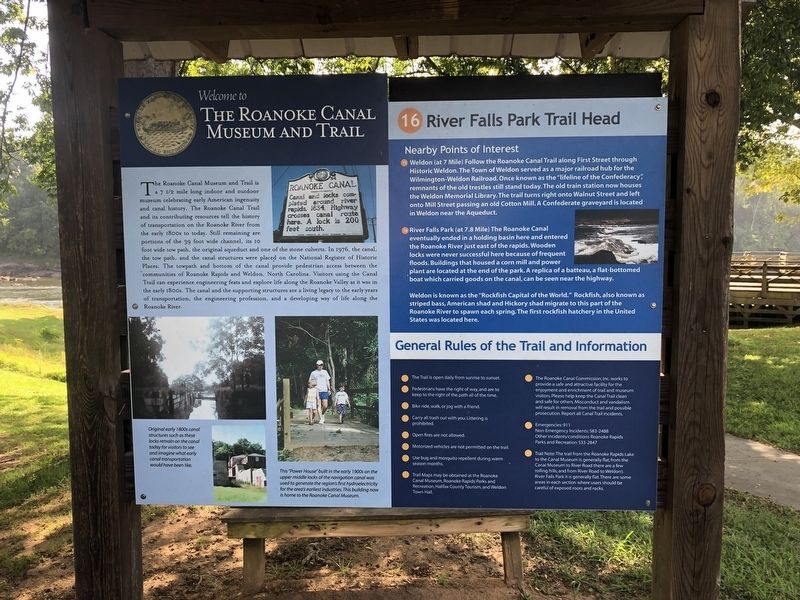
Welcome to The Roanoke Canal Museum and Trail
The Roanoke Canal Museum and Trail is a 7 1/2 mile long indoor and outdoor museum celebrating early American ingenuity and canal history. The Roanoke Canal Trail and it contributing resources tell the history of transportation on the Roanoke River from the early 1800s to today. Still remaining are portions of the 39 foot wide channel, its 10 foot wide tow path, the original aqueduct and one of the stone culverts. In 1976, the canal, the tow path, and the canal structures were placed on the National Register of Historic Places. The towpath and bottom of the canal provide pedestrian of the canal provide pedestrian access between the communities of Roanoke Rapids and Weldon, North Carolina. Visitors using the Canal Trail can experience engineering feats and explore life along the Roanoke Valley as it was in the early 1800s. The canal and the supporting structures are a living legacy to the early years of transportation, the engineering profession, and a developing way of life along the Roanoke River.
[Captions:]
Original early 1800s canal structures such as these locks remain on the canal today for visitors to see and imagine what early canal transportation would have been like.
This "Power House" built in the early 1900s on the upper middle locks of the navigation canal was used to generate the region's first hydroelectricity for the area's earliest industries. This building now is home to the Roanoke Canal Museum.
16. River Falls Park Trail Head
Nearby Points of Interest
15. Weldon (at 7 Mile) Follow the Roanoke Canal Trail along First Street though historic Weldon. The Town of Weldon served as a major railroad hub for the Wilmington-Weldon Railroad. Once known as the "lifeline of the Confederacy", remnants of the old trestles still stand today. The old train station now houses the Weldon Memorial Library. The trail turns right onto Walnut Street and left onto Mill Street passing an old Cotton Mill. A Confederate graveyard is located in Weldon near the Aqueduct.
16. River Falls Park (at 7.8 Mile) The Roanoke Canal eventually ended in a holding basin here and entered the Roanoke River just east of the rapids. Wooden locks were never successful here because of frequent floods. Buildings that housed a corn mill and power plant are located at the end of the park. A replica of a batteau, a flat-bottomed boat which carried goods on the canal, can be seen near the highway.
Weldon is known as the "Rockfish Capital of the World." Rockfish, also known as striped bass, American shad and Hickory shad migrate to this part
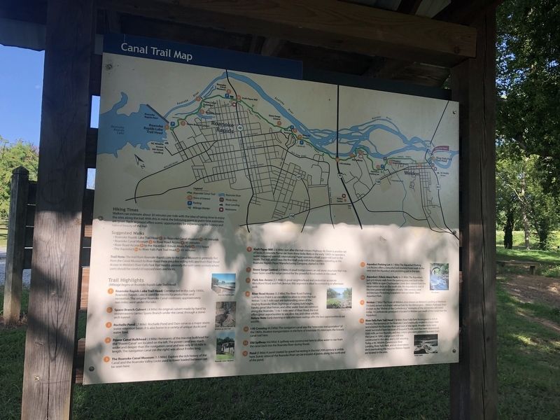
Canal Trail Map
Trail Highlights
(Mileage begins at Roanoke Rapids Lake Trail Head)
1. Roanoke Rapids Lake Trail Head; Constructed in the early 1950s, Roanoke Rapids Lake is used for electricity production and recreation. The original Roanoke Canal continues approximately two miles west under the lake.
2. Spans Branch Culvert (.4 Mile) An original culvert made by hand by stonemasons carries Spans Branch under the canal, through a stone-arch tunnel.
3. Rochelle Pond (.7 Mile) Rochelle Pond and Dam serve as a major storm water retention basin. It is also home to a variety of unique ducks and water fowl.
4. Power Canal Bulkhead (.9 Mile) Remnants of the massive bulkhead for the "Power Canal" are located on the left. The power canal was much wider and deeper than the navigation canal and was only 8/10 mile in length. The navigation canal (on the right) was about 9 miles long.
5. The Roanoke Canal Museum (1.5 Mile) Explore the rich history of the Canal and the Roanoke Valley. Locks used to lower loaded batteaux can be seen here.
6. Kraft Paper Mill (1.6 Mile) Just after the trail crosses Highway 48, there

Photographed By Devry Becker Jones (CC0), August 27, 2021
3. Welcome to The Roanoke Canal Museum and Trail / Canal Trail Map Marker
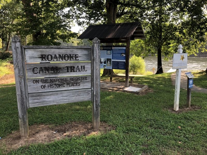
In the foreground is a sign indicating the site's placement on the National Register of Historic Places and the National Underground Railroad Network to Freedom Trail.
7. Stone Surge Control (2.9 Mile) A small bridge covers an old stone structure that may have been used for surge control for the powerful flood waters in the canal.
8. Park Ave. Access (3.1 Mile) A great neighborhood and pedestrian access to Woodland Road and Park Avenue, this segment is ideal for a morning or afternoon walk.
9. River Road Access (3.3 Mile) The River Road Parking Lot/Access Point is an excellent location to enter the trail. Within ½ to 1 mile west of River Road, the trail offers great opportunities to see deer, fox, and other wildlife.
Nature Note: Early morning or late afternoon outings offer the best opportunities to see wildlife.
10. I-95 Crossing (4.3 Mile) The navigation canal was the "interstate transportation" of the 1800s. Modern transportation in the form of Interstate 95, intercepts the historic canal trail here.
11. Old Spillway (4.6 Mile) A spillway was constructed here to allow water to run from the canal back into
12. Pond (5 Mile) A pond created by gravel harvesting in the mid 20th century is visible here. Scenic vistas of the Roanoke River can be enjoyed at points along the north end of the pond.
13. Aqueduct Parking Lot (6.1 Mile) The Aqueduct Parking Lot/Access offers a beautiful lush lowland forest walk to the west and the Aqueduct and picnicking just to the east.
14. Aqueduct (Edwin Akers Park) (6.25 Mile) The Aqueduct, just a 4 minute walk from the parking area, was built in the early 1800s to span Chockoyette Creek. Best viewed from observation deck on the south side, the Aqueduct is one of the best preserved examples of early 19th century canal architecture.
15. Weldon (7 Mile) The Town of Weldon, once known as Weldon's Landing or Weldon's Orchard, served as a major railroad hub for the Wilmington-Weldon Railroad. Once known as the "lifeline of the Confederacy," remnants of the old trestles still stand today. A Confederate graveyard is located in Weldon just south of the canal near the Aqueduct.
16. River Falls Park Trail Head (7.8 Mile) River Falls Park/Access point is rich in history. The terminus of the Roanoke Canal eventually ended in a basin here and entered the Roanoke River just east of the rapids. Wooden locks were never successful here because of frequent floods, and thus were abandoned. Grist mills, an iron foundry, and two cotton gins were powered by water from the canal. In 1890, a large corn mill was constructed in this area, and is still standing. Today, a NC Wildlife Commission Boat Landing, River Falls Park, and an observation deck overlooking the massive Weldon Rapids area located in the area.
Erected by North Carolina Department of Transportation.
Topics. This historical marker is listed in these topic lists: Industry & Commerce • Railroads & Streetcars • War, US Civil • Waterways & Vessels. A significant historical year for this entry is 1976.
Location. 36° 25.677′ N, 77° 35.502′ W. Marker is in Weldon, North Carolina, in Halifax County. Marker is on Rockfish Drive, 0.1 miles U.S. 158/301, on the left when traveling south. Touch for map. Marker is at or near this postal address: 50 Rockfish Dr, Weldon NC 27890, United States of America. Touch for directions.
Other nearby markers. At least 8 other markers are within walking distance of this marker. Conservation Pays Off (within shouting distance of this marker); The Mills at Weldon (about 400 feet away, measured in a direct line); Wilmington & Weldon RR Trestle (about 700 feet away); Roanoke Canal (approx. 0.2 miles away); Historic Weldon Railroad (approx. ¼ mile away); Roanoke River (approx. ¼ mile away); Wilmington and Weldon Railroad (approx. ¼ mile away); Weldon Railroads (approx. ¼ mile away). Touch for a list and map of all markers in Weldon.
Credits. This page was last revised on August 28, 2021. It was originally submitted on August 28, 2021, by Devry Becker Jones of Washington, District of Columbia. This page has been viewed 277 times since then and 26 times this year. Photos: 1, 2, 3, 4. submitted on August 28, 2021, by Devry Becker Jones of Washington, District of Columbia.

