Gambles Hill in Richmond, Virginia — The American South (Mid-Atlantic)
Water Power
— Captain John Smith Chesapeake National Historic Trail —
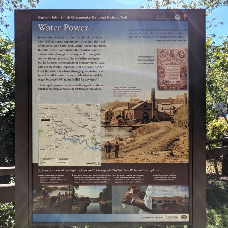
These rapids powered the famous Tredegar Iron Works, and they are popular today for whitewater recreation.
"...we were intercepted with great craggy stones that [stand] in midst of the river, where the water falleth so rudely and with such a violence as not any boat can possibly pass..."
— Captain John Smith, A True Relation, 1608
(sidebar)
Experience more of the Captain John Smith Chesapeake Trail at these Richmond-area places:
• Enjoy biking along the Virginia Capital Trail, a biking and pedestrian trail linking Richmond to Historic Jamestowne.
• Visit Great Shiplock Park to see the 19th-century lock that by-passed the falls, connecting the James River with the Richmond Dock. This is the western trailhead of the Virginia Capital Trail.
• At Ancarrow's Landing, you can launch a boat into the tidal waters of the James River or cast a line from shore to enjoy some of the area's best fishing.
• Enjoy fishing, bird watching. tubing. canoeing. or a scenic hike at Pony Pasture Park.
(captons)
Decorative tide page from one of Smith's publications. What we know about this period in Virginia comes largely from the writings of Smith and fellow Jamestown colonists Gabriel Archer and George Percy.
Tredegar Iron Works, located here because of the water power, was once one of the nation's largest iron manufacturers. The main building now serves as a National Park Service visitor center. Image Library of Congreess, Alexander Gardner, 1865
Erected by National Park Service, U.S. Department of the Interior.
Topics and series. This historical marker is listed in these topic lists: Exploration • Industry & Commerce • Parks & Recreational Areas • Waterways & Vessels. In addition, it is included in the Captain John Smith Chesapeake National Historic Trail series list. A significant historical month for this entry is May 1607.
Location. 37° 32.06′ N, 77° 26.923′ W. Marker is in Richmond, Virginia. It is in Gambles Hill. Marker is on Tredegar Street, 0.1 miles west of Brown's Island Way, on the left when traveling west. Touch for map. Marker is in this post office area: Richmond VA 23219, United States of America. Touch for directions.
Other nearby markers. At least 8 other markers are within walking distance of this marker. Welcome to Richmond’s Historic Riverfront (a few steps from this marker); Belle Isle (within shouting distance of this marker); Robert E. Lee Bridge (about 400 feet away, measured in a direct line); Tredegar in the Twentieth Century / Then and Now (about 600 feet away); Horseshoe Shops (about 600 feet away); Making Machines at Tredegar (about 600 feet away); Industrial Recycling (about 600 feet away); Tredegar Rolling Mills (about 600 feet away). Touch for a list and map of all markers in Richmond.
Credits. This page was last revised on February 1, 2023. It was originally submitted on September 28, 2021, by Bernard Fisher of Richmond, Virginia. This page has been viewed 151 times since then and 8 times this year. Photos: 1, 2, 3. submitted on September 28, 2021, by Bernard Fisher of Richmond, Virginia.


