Old Saybrook Center in Middlesex County, Connecticut — The American Northeast (New England)
The Saybrook Bar
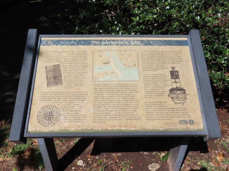
Ever since Adrian Block's discovery of the Connecticut River in 1614, the extensive bar at its mouth has been an obstacle for mariners, preventing vessels of deep draft from entering. The runoff from the source of the river in Canada traveling south through Vermont, New Hampshire, Massachusetts and finally Connecticut carries much silt with it. In the spring when all the snow and ice is melting the runoff is especially heavy. This is called a "freshet". When the silt arrives here and meets the Long Island Sound it starts to settle out. Before it all settles out the incoming tide pushes the suspended silt into North Cove and other areas where it finally settles as the current is much weaker once inside the cove. Little by little it fills in. The constant flow of silt downstream is deposited at the mouth because of the confluence at the widening of the river with tidal Long Island Sound.
The bar is the main reason that Old Saybrook never became a major port. In the eighteenth century, the heyday of valleyshore shipbuilding, ships of more than five hundred tons had to be floated over the bar in spring freshets. The twenty-eight gun U.S. Frigate Trumbull, one of the thirteen original frigates ordered by the Continental Congress in 1775 and built by John Cotton Chatham in Chatham (now Portland), was launched on September 5, 1776. However, after the frigate had been launched, her builders discovered that her deep draft could make it extremely difficult to get the ship across the bar at the mouth of the Connecticut River into Long Island Sound. The following spring, as Trumbull lay in the river at Saybrook awaiting assistance in getting out to deep water, her safety became a matter of great concern to Continental naval authorities. In April General Howe ordered General Tryon, the Royal Governor of New York, to lead a raid into neighboring Connecticut. Tryon's forces landed at Fairfield, marched in land and burned Continental public stores at Danbury. A small force of Americans harassed the British troops as they marched back to their ships. Fortunately, Tryon did not attack the berth on the Connecticut River where Trumbull—protected by neither gun nor warships—lay virtually defenseless. After three years of inactivity, Trumbull was finally freed in 1779. Capt. Elisha Hinman suggested that casks of water be lashed alongside, port and starboard; with stout ropes running beneath the keel. When the casks were pumped out they rose and lifted the ship just enough in the water so as to permit passage over the bar. Trumbull then was fitted out for sea at New London, Conn., under the direction of Nathaniel Shaw.
The first attempt to improve navigation on the river came in 1773 when Hartford's leading
merchant, Jeremiah Wadsworth, persuaded the legislature to approve Connecticut's first lottery. The “Saybrooke Bay Lottery” was held to “raise the sum of 537 pounds lawful money” to remove the sand bar at the river's mouth, dredge a channel, and lay out buoys to mark the entrance to the Connecticut. After 1800, a seven to nine foot channel was maintained. In 1870, the U.S. Army Corps of Engineers began regular dredging of the mouth of the river to accommodate a growing number of steamboats and tugs.
The U.S. Army Corps of Engineers constructed the two parallel stone jetties at the river's mouth in 1876. These jetties trap the sand that would have been deposited there and obstructed navigation. The westernmost jetty has allowed the adjacent beach to increase in width by about 700 feet in nearly 100 years. The jetties have worked to confine the channel and to provide the modern fifteen foot channel.
The shallow depth of the river's mouth combined with the constantly shifting shoals and sandbars, have prevented the establishment of a deep water port with all of its accompanying industries therefore preserving unique and critical marine habitats. Today the Connecticut River is one of the few American rivers without a major city at its mouth. Please take the time to enjoy and appreciate its unspoiled beauty.
Topics. This historical marker is listed in these topic lists: Colonial Era • Natural Features • War, US Revolutionary • Waterways & Vessels. A significant historical date for this entry is September 5, 1776.
Location. This marker has been replaced by another marker nearby. It was located near 41° 17.074′ N, 72° 21.108′ W. Marker was in Old Saybrook, Connecticut, in Middlesex County. It was in Old Saybrook Center. Marker could be reached from College Street (Connecticut Route 154) east of Fenwick Street, on the left when traveling east. Located in Fort Saybrook Monument Park. Touch for map. Marker was in this post office area: Old Saybrook CT 06475, United States of America. Touch for directions.
Other nearby markers. At least 8 other markers are within walking distance of this location. Fishing on the Connecticut (here, next to this marker); a different marker also named The Saybrook Bar (here, next to this marker); Adriaen Block & New Netherland (a few steps from this marker); Welcome to Fort Saybrook (a few steps from this marker); Battlefields of the Pequot War (within shouting distance of this marker); The Connecticut River (within shouting distance of this marker); The Connecticut Valley Railroad (within shouting distance of this marker); Fort Saybrook – 1635 (within shouting distance of this marker). Touch for a list and map of all markers in Old Saybrook.
Related marker. Click here for another marker that is related to this marker. This marker has been replaced with the linked marker, whose inscription is slightly different.
Credits. This page was last revised on July 1, 2023. It was originally submitted on September 28, 2021, by Michael Herrick of Southbury, Connecticut. This page has been viewed 129 times since then and 5 times this year. Photos: 1, 2. submitted on September 28, 2021, by Michael Herrick of Southbury, Connecticut.

