Westmoreland in Macon County, Tennessee — The American South (East South Central)
Site of Epperson Springs
Named for Ananias Epperson
| — | A mineral springs summer resort | — |
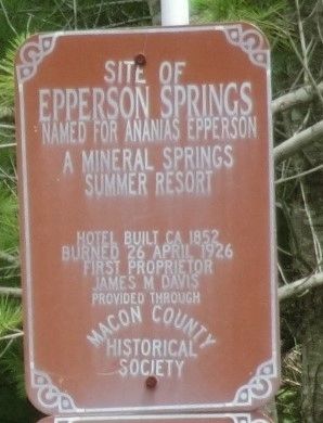
Photographed by Don Morfe, July 23, 2013
1. Site of Epperson Springs Marker
Erected by Macon County Historical Society.
Topics. This historical marker is listed in these topic lists: Industry & Commerce • Parks & Recreational Areas • Waterways & Vessels. A significant historical date for this entry is April 26, 1926.
Location. 36° 34.401′ N, 86° 11.986′ W. Marker is in Westmoreland, Tennessee, in Macon County. It is on Epperson Springs Road 0.2 miles west of Tooley Branch Road, on the left when traveling south. Touch for map. Marker is at or near this postal address: 9695 Epperson Springs Rd, Westmoreland TN 37186, United States of America. Touch for directions.

Regionally, this marker is in Middle Tennessee and in the Highland Rim. It is also in the American South and specifically in the Upper South. Globally, it is in North America, the Western Hemisphere, the Western World, and the Anglosphere. Historically, it finds itself in what was once the territory of the Mississippian Culture, one of the Confederate States of America, and the Antebellum South.
Other nearby markers. At least 8 other markers are
this page online
Another marker is no longer nearby. Epperson Springs (was here, next to this marker but has been confirmed missing).

Photographed by Don Morfe, July 23, 2013
2. Site of Epperson Springs Marker
Credits. This page was last revised on September 30, 2021. It was originally submitted on September 30, 2021, by Don Morfe of Baltimore, Maryland. This page has been viewed 797 times since then and 80 times this year. Photos: 1, 2. submitted on September 30, 2021, by Don Morfe of Baltimore, Maryland. • Devry Becker Jones was the editor who published this page.
