Near White in Brookings County, South Dakota — The American Midwest (Upper Plains)
Lake Hendricks State Park
⎯⎯⎯
Brookings County

August 15, 2021
1. Lake Hendricks State Park Marker
The log cabin was moved here as a fitting memorial to the sturdy pioneers who settled in this part of Brookings County in the 1870s and 1880s. The park itself was opened in 1951.
The log cabin has had three locations. It was built of well-hewn oak logs taken from the shore of Oak Lake. Nils Bogen built it in 1874 in the center of NE ¼ of 18-112-47, ¼ mile west of Oak Lake. In 1884 the log house was taken apart, the logs numbered, and moved 2½ miles S to the SW ¼ of 30-112-47 and rebuilt.
In 1884 Even Anderson bought it and his family lived in it until about 1893. Thereafter a renter, Theodor Sand, and his family lived in it from about 1895 to 1903. Esten Johnson bought the farm and moved his frame house to it, attaching it to the log house about 1906. The farm was sold to Marvin Vizecky, from
this page online
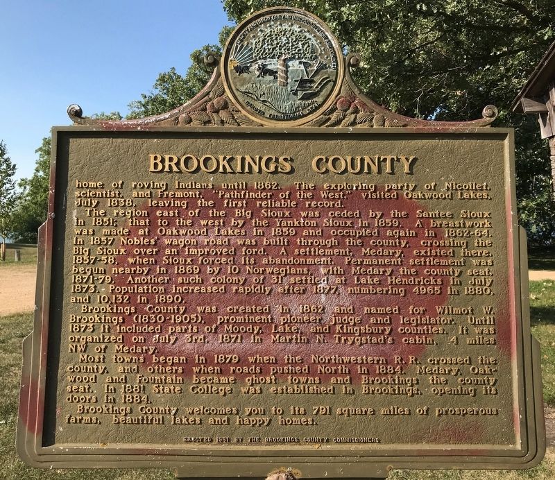
The region east of the Big Sioux was ceded by the Santee Sioux in 1851; that to the west by the Yankton Sioux in 1859. A breastwork was made at Oakwood Lakes in 1859 and occupied again in 1862-64. In 1857 Nobles' wagon road was built through the county, crossing the Big Sioux over an improved ford. A settlement, Medary, existed there, 1857-58, when Sioux forced its abandonment. Permanent settlement was begun nearby in 1869 by 10 Norwegians, with Medary the county seat, 1871-79. Another such colony of 31 settled at Lake Hendricks in July 1873. Population increased rapidly after 1877, numbering 4965 in 1880, and 10,132 in 1890.
Brookings County was created in 1862 and named for Wilmot W. Brookings (1830-1905), prominent pioneer judge and legislator. Until 1873 it included parts
August 15, 2021
2. Brookings County Marker
Most towns began in 1879 when the Northwestern R. R. crossed the county, and others when roads pushed North in 1884. Medary, Oakwood and Fountain became ghost towns and Brookings the county seat. In 1881 State College was established in Brookings, opening its doors in 1884.
Brookings County welcomes you to its 791 square miles of prosperous farms, beautiful lakes and happy homes.
Erected 1961 by Brookings County Commissioners. (Marker Number 330.)
Topics and series. This historical marker is listed in these topic lists: Indigenous Peoples and Communities • Settlements & Settlers • Waterways & Vessels. In addition, it is included in the Norwegian-Americans, and the South Dakota State Historical Society Markers series lists. A significant historical year for this entry is 1951.
Location. 44° 28.815′ N, 96° 28.639′ W. Marker is near White, South Dakota, in Brookings County. It is on Unnamed Road 0.7 miles north of 201st Street, on the right when traveling north. The marker is located at the Lake

August 15, 2021
3. Lake Hendricks State Park Marker

Regionally, this marker is in the Sisseton-Wahpeton Oyate and in East River. It is also in the American Midwest, in the Lewis & Clark Corridor, in the Corn Belt, on the prairies, and on the Northern Plains. Globally, it is in North America, the Western Hemisphere, the Western World, and the Anglosphere. Historically, it finds itself in what was once Rupert’s Land and also the Louisiana Purchase.
Other nearby markers. At least 8 other markers are within 15 miles of this marker, measured as the crow flies: Singsaas Lutheran Church (approx. 3.2 miles away); Lake Hendricks Norwegian Colony of 1873 / Brookings County (approx. 3½ miles away); Lake Hendricks Norwegian Evangelical Lutheran Church (approx. 4.1 miles away in Minnesota); Seventh Day Adventist Church (approx. 8.3 miles away in Minnesota); White Area Veterans Memorial (approx. 9.1 miles away); Olson, Arlo L. (approx. 10.4 miles away); The Danish Lutheran Church (approx. 14.2 miles away in Minnesota); Danish Congregation WWI Memorial

August 15, 2021
4. Brookings County Marker
Regarding Lake Hendricks State Park / Brookings County. The area is named Lake Hendricks Lakeside Use Area.
Credits. This page was last revised on October 20, 2021. It was originally submitted on August 19, 2021. This page has been viewed 678 times since then and 81 times this year. Last updated on October 19, 2021. Photos: 1, 2, 3, 4. submitted on August 19, 2021. • J. Makali Bruton was the editor who published this page.
