
Near Winchester in Frederick County, Virginia — The American South (Mid-Atlantic)
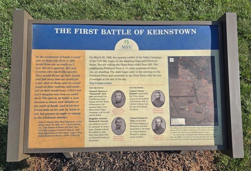
The First Battle Of Kernstown
Photographed by Bradley Owen, August 29, 2026
1. The First Battle Of Kernstown Marker
(sidebar)
In the excitement of battle I could aim at them only forty or fifty yards from me, as coolly as I ever did at a squirrel. But now it seems very much like murder. They would throw up their hands and fall every time we would get a fair shot at them, and we would laugh at their motions and make jest at their misfortune. I don't nor can't imagine now how we could do it. The fact is, in battle a man becomes a sinner and delights at the work of death. And if his best friend falls at his side he heeds it not, but presses on eager to engage in the wholesale murder.
John G. Marsh, 29th Ohio Regiment, to his father, April 10, 1862, in C. Cavins Smithy, ed., "The Duties of Home and War: The Civil War Letters of John G. Marsh, 19th Ohio Volunteers (A Selection),” Upper Ohio Valley Historical Review (1979), VIII(2):10.
(main text)
On March 23, 1862, the opening conflict of the Valley Campaign of the Civil War began on the adjoining Glass and Pritchard farms. You are visiting the Glass Farm called Rose Hill. The neighboring Pritchard Farm is 1 1/2 miles southeast of where you are standing. The clash began early in the
this page online
The Commanders
For the South
General Thomas J. "Stonewall” Jackson commanded the Confederate troops during the First Battle of Kernstown, the opening battle of his Shenandoah Valley Campaign, and his only tactical defeat.
Brigadier General Richard B. Garnett was Jackson’s second in command. In desperation, Garnett ordered his soldiers to withdraw from the battle without Stonewall Jackson’s permission.
For the North
Colonel Nathan Kimball commanded the Union troops during the First Battle of Kernstown with an infantry division twice the size of the Southern forces.
Colonel Erastus B. Tyler commanded the Union infantry in Winchester and was dispatched to the battle by Colonel Nathan Kimball to capture enemy artillery.
The walking trail includes interpretive signs about the Rose Hill portion of the First Battle of Kernstown. From here to the stone wall is .3 miles. The trail forms an additional loop of 1.1 miles.
The trail surface is compacted stone. Please be prepared for hills and wildlife. Trail grade to the stone wall may reach up to 8%. Areas of the loop remainder may exceed 8% for short distances.
Erected by Museum

Photographed by Bradley Owen, October 15, 2021
2. The First Battle Of Kernstown Marker
Marker is on the left.
Topics. This historical marker is listed in this topic list: War, US Civil. A significant historical date for this entry is March 23, 1862.
Location. 39° 9.195′ N, 78° 13.189′ W. Marker is near Winchester, Virginia, in Frederick County. It is on Jones Road (Virginia Route 621) 0.4 miles south of Cedar Creek Grade ( Route 622), on the left when traveling south. Marker is at the beginning of the walking trail off the parking lot at the entrance to Rose Hill Park. Touch for map. Marker is at or near this postal address: 1871 Jones Road, Winchester VA 22602, United States of America. Touch for directions.

Regionally, this marker is in Virginia’s Shenandoah Valley. It is also in the American South, specifically in the Upper South, and in the Mid-Atlantic. Globally, it is in North America, the Western Hemisphere, the Western World, and the Anglosphere. Historically, it finds itself in what was once the territory of the Mississippian Culture, one of the original Thirteen Colonies, one of the Confederate States of America, and the Antebellum South.
Other nearby markers. At least 8 other markers are
Photographed by Bradley Owen
3. The First Battle Of Kernstown Trail Changes
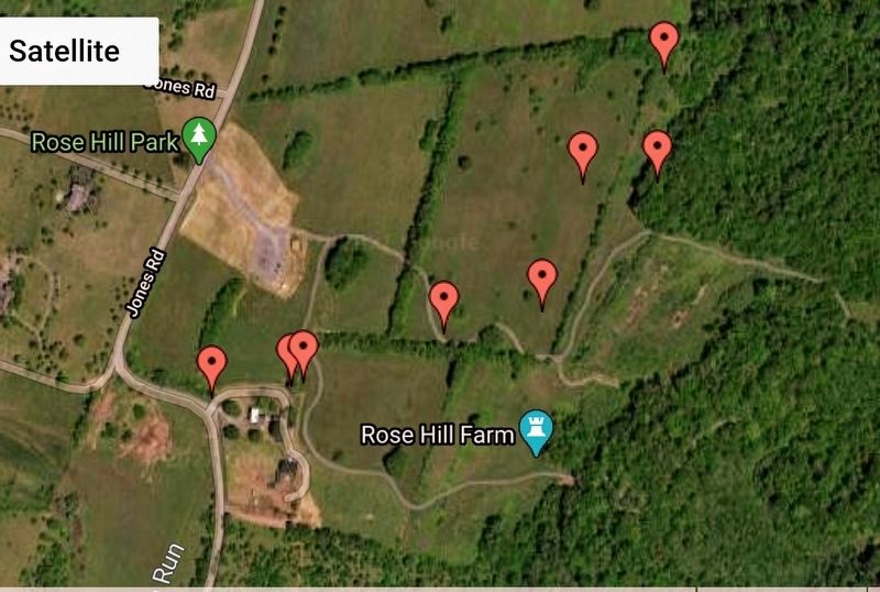
From the satellite view, it can be seen that the path of the trail at Rose Hill Park has changed since the original markers were placed. The format and content of the markers have changed somewhat, but the content described is now closer to where the action actually took place.
Other markers no longer nearby. How To See the Battlefield (was about 600 feet away but has been permanently removed); War in the Backyard (was about 600 feet away but has been permanently removed); a different marker also named Rose Hill (was about 700 feet away but has been replaced with another marker now near it); Northern Victory, Southern Defeat (was approx. 0.2 miles away but has been replaced with another marker now near it); The Defense of the Stone Wall (was approx. 0.2 miles away but has been replaced with another marker now near it); The Order for Retreat (was approx. ¼ mile away but has been replaced with another marker now near it); The Advance of Tyler’s Brigade (was approx. ¼ mile away but has been replaced with another marker now near it).
Also see . . . Rose Hill Park. Museum of the Shenandoah Valley (Submitted on April 7, 2021.)
Credits. This page was last revised on September 7, 2026. It was originally submitted on April 5, 2021, by Bradley Owen of Morgantown, West Virginia. This page has been viewed 608 times since then and 40 times this year. Last updated on November 1, 2021, by Bradley Owen of Morgantown, West Virginia. Photos: 1. submitted on September 7, 2026, by Bradley Owen of Morgantown, West Virginia. 2. submitted on October 22, 2021, by Bradley Owen of Morgantown, West Virginia. 3. submitted on April 5, 2021, by Bradley Owen of Morgantown, West Virginia. • J. Makali Bruton was the editor who published this page.
