East End in Portland in Cumberland County, Maine — The American Northeast (New England)
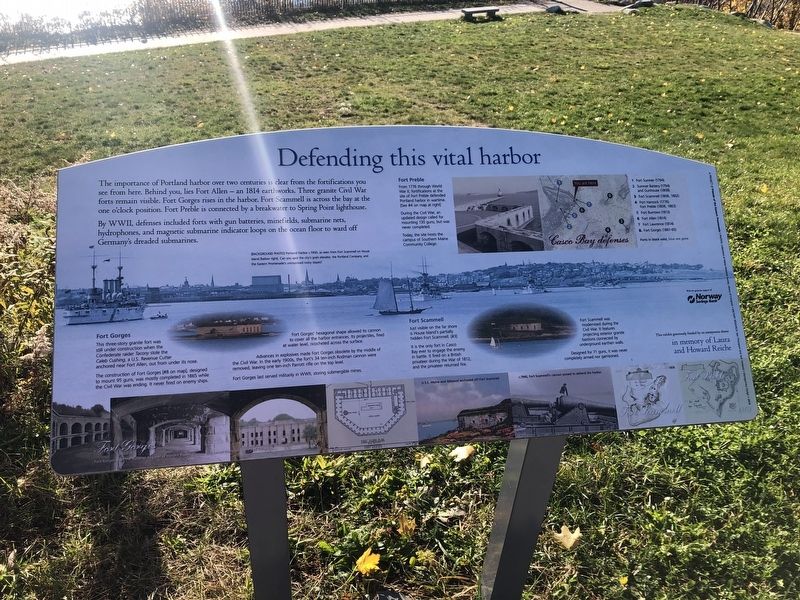
Defending this vital harbor
The importance of Portland harbor over two centuries is clear from the fortifications you see from here. Behind you, lies Fort Allen — an 1814 earthworks. Three granite Civil War forts remain visible. Fort Gorges rises in the harbor. Fort Scrammel is across the bay at the one o'clock position. Fort Preble is connected by a breakwater to Spring Point lighthouse.
By WWII, defenses included forts with gun batteries, minefields, submarine nets, hydrophones, and magnetic submarine indicator loops on the ocean floor to ward off Germany's dreaded submarines.
Fort Gorges
This three-story granite fort was still under construction when the Confederate raider Tacony stole the Caleb Cushing, a U.S. Revenue Cutter anchored near Fort Allen, out from under its nose.
The construction of Fort Gorges [#8 on map], designed to mount 95 guns, was mostly completed in 1865 while the Civil War was ending. It never fired on enemy ships.
Fort Gorges' hexagonal shape allowed its cannon to cover all the harbor entrances. Its projectiles, fired at water leve, ricocheted across the surface.
Advances in explosives mad Fort Gorges obsolete by the middle of the Civil War. In the early 1900s, the fort's 34 ten-inch Rodman cannon were removed, leaving one ten-inch Parrott rifle on the top level.
Fort Gorges last serve militarily in WWII, storing submergible mines.
Fort Scammell
Just visible on the far shore is House Island's partially hidden Fort Scammell. [#3]
It is the only fort in Casco Bay ever to engage the enemy in battle. It fired on a British privateer during the War of 1812; and the privateer returned fire.
Fort Scammell was modernized during the Civil War. It features projecting exterior granite bastions connected by underground earthen walls.
Designed for 71 guns, it was never completely armed nor garrisoned.
Fort Preble
From 1776 through World War II, fortifications at the site of Fort Preble defended Portland harbor in wartime. [See #4 on the map at right]
During the Civil War, an updated design called for mounting 130 guns, but was never completed.
Today, the site hosts the campus of Southern Maine Community College.
Erected by Friends of the Eastern Promenade.
Topics. This historical marker is listed in these topic lists: Forts and Castles • War, US Civil • War, World II • Waterways & Vessels. A significant historical year for this entry is 1814.
Location. 43° 39.903′ N, 70° 14.415′ W. Marker is in Portland, Maine
Other nearby markers. At least 8 other markers are within walking distance of this marker. Remember the Maine (a few steps from this marker); Portland Maine Fort Allen Park USS Maine Memorial (a few steps from this marker); The poet & the view (a few steps from this marker); 1893 Bandstand (within shouting distance of this marker); 9/11 Memorial (within shouting distance of this marker); Boxer and Enterprise (within shouting distance of this marker); 20,000 Civil War veterans tent here (within shouting distance of this marker); Portland Maine Fort Allen Park GAR memorial (within shouting distance of this marker). Touch for a list and map of all markers in Portland.
Credits. This page was last revised on February 13, 2023. It was originally submitted on November 21, 2021, by Devry Becker Jones of Washington, District of Columbia. This page has been viewed 208 times since then and 14 times this year. Photos: 1, 2. submitted on November 21, 2021, by Devry Becker Jones of Washington, District of Columbia.

