East Bayside in Portland in Cumberland County, Maine — The American Northeast (New England)
Welcome to Back Cove Trail: An urban ecosystem
⎯⎯⎯
Explore: Portland's Magic Spaces
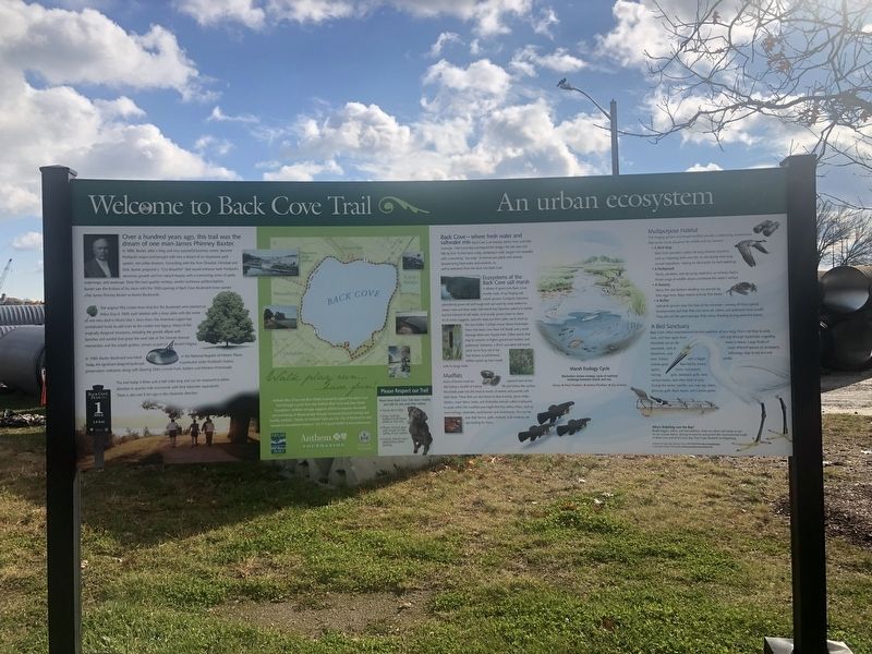
Photographed by Devry Becker Jones (CC0), November 15, 2021
1. Welcome to Back Cove Trail: An urban ecosystem / Explore: Portland's Magic Spaces Marker
Welcome to Back Cove Trail: An urban ecosystem
Over a hundred years ago, this trail was the dream of one man-James Phinney Baxter.
In 1893, Baxter after a long and very successful business career, became Portland's mayor and brought with him a dream of an impressive park system, not unlike Boston's. Consulting with the firm Olmsted, Olmsted and Eliot. Baxter proposed a "City Beautiful" that would enhance bot Portland's economic growth and her natural beauty with a connecting series of parks, waterways, and roadways. Over the next quarter century, amidst numerous political battles, Baxter saw the fruition of his vision with the 1920 opening of Back Cove Boulevard (now named after James Phinney Baxter as Baxter Boulevard).
The original fifty Linden trees that line the Boulevard were planted on Arbor Day in 1920, each labeled with a brass plate with the name of one who died in World War I. Since then, the American Legion has contributed funds to add trees to the Linden tree legacy. Many of the originally designed structures, including the granite ellipse with benches and sundial that grace the west side of the Vannah
this page online
In 1989, Baxter Boulevard was listed in the National Register of Historic Places. Today, this significant deigned landscape is protected under Portland's historic preservation ordinance along with Deering Oaks, Lincoln Park, Eastern and Western Promenade.
The trail today is three and a half miles long and can be measured in either direction in quarter mile increments with their kilometer equivalents. There is also one 5 km sign in the clockwise direction.
Explore: Portland's magic spaces
Over a century ago, Mayor James Phinney Baxter proposed an "emerald necklace" of interconnected parks in Portland. Back Cove, the Eastern and Western Promenades, Evergreen Cemetery, and Deering Oaks. In the 1980s, the City's Shoreway Access Plan dramatically expanded and enhanced that original vision by proposing a system of trails linking the city's places of wonder. The parks, marshes, rivers, and coastline of Portland give the "Forest City" a unique identity. They are remnants of our natural heritage, crucial to our legacy.
Since its founding in 1991, Portland Trails has helped make these plans a reality.
Portland

Photographed by Devry Becker Jones (CC0), November 15, 2021
2. Welcome to Back Cove Trail: An urban ecosystem / Explore: Portland's Magic Spaces Marker
• Create and maintain a 50-mile network of trails in greater Portland.
• Engage the participation of neighborhoods, schools, and the business community in trail use and land stewardship.
• Make Greater Portland a model for people-powered recreation and transportation.
Topics. This historical marker is listed in these topic lists: Architecture • Parks & Recreational Areas • Waterways & Vessels. A significant historical year for this entry is 1893.
Location. 43° 39.932′ N, 70° 16.176′ W. Marker is in Portland, Maine, in Cumberland County. It is in East Bayside. It is on Back Cove Trail 0.1 miles east of Baxter Bouleard, on the right when traveling east. Touch for map. Marker is at or near this postal address: 53 Baxter Blvd, Portland ME 04101, United States of America. Touch for directions.

Regionally, this marker is in the American Northeast, in New England, and on the Eastern Seaboard. Globally, it is in the North Atlantic Region, North America, the Western Hemisphere, the Western World, and the Anglosphere.
Other nearby markers. At least 8 other markers are within walking distance of this marker: Baxter Trail: Discover the Baxters' legacy in Portland (a few steps from this marker); Back Cove Trail (about 800 feet away, measured in a direct line); Spanish-American War Memorial (approx. half a mile away); First Parish Church, Unitarian Universalist (approx. ¾ mile away); Asa Clapp / Asa William Henry Clapp / Mary Jane Emerson Clapp (approx. ¾ mile away); Portland Maine World War II Memorial (approx. ¾ mile away); Portland Maine Spanish War / World War I Memorial (approx. ¾ mile away); Portland Maine World War I Marker (approx. ¾ mile away). Touch for a list and map of all markers in Portland.
Credits. This page was last revised on February 13, 2023. It was originally submitted on November 22, 2021, by Devry Becker Jones of Washington, District of Columbia. This page has been viewed 622 times since then and 41 times this year. Photos: 1, 2. submitted on November 22, 2021, by Devry Becker Jones of Washington, District of Columbia.
