Blackstone in Nottoway County, Virginia — The American South (Mid-Atlantic)
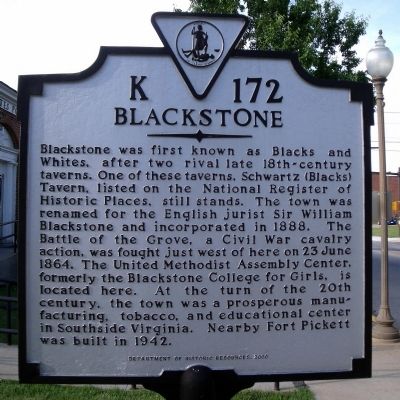
Blackstone
Erected 2000 by Department of Historic Resources. (Marker Number K-172.)
Topics and series. This historical marker is listed in these topic lists: Colonial Era • Military • War, US Civil. In addition, it is included in the Virginia Department of Historic Resources (DHR) series list. A significant historical date for this entry is June 23, 1864.
Location. 37° 4.654′ N, 77° 59.949′ W. Marker is in Blackstone, Virginia, in Nottoway County. Marker is on South Main Street (Business U.S. 460) 0.1 miles south of West Irvin Street, on the right when traveling south. Touch for map. Marker is in this post office area: Blackstone VA 23824, United States of America. Touch for directions.
Other nearby markers. At least 8 other markers are within walking distance of this marker. War Memorial (about 400 feet away, measured in a direct line); First National Bank of Blackstone, VA. (approx. 0.2 miles away); The L.C. Tucker Building, 101 S. Main Street (approx. 0.2 miles away); L.B. Spencer Drug Company (approx. ¼ mile away); 108 North Main Street (approx. ¼ mile away); Dodge Brothers Dealership (approx. 0.3 miles away); The Blackstone Hotel (approx. 0.3 miles away); Black’s and White’s Station (approx. 0.3 miles away). Touch for a list and map of all markers in Blackstone.
Also see . . . Blackstone Historic District. National Register of Historic Places (Submitted on November 10, 2021.)
Credits. This page was last revised on November 10, 2021. It was originally submitted on May 12, 2009, by Bernard Fisher of Richmond, Virginia. This page has been viewed 1,374 times since then and 67 times this year. Photos: 1, 2, 3. submitted on May 12, 2009, by Bernard Fisher of Richmond, Virginia.


