Yankton in Yankton County, South Dakota — The American Midwest (Upper Plains)
Sculpting the Landscape
— Missouri National Recreational River —
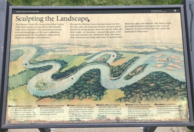
Because the Missouri loses elevation about one foot for every mile, the waters do not pick up much speed. Instead of cutting straight down through the valley, the river winds—or meanders—around high spots, solid rock, and resistant soils. Behind the dams, the waters slow even more and dump their loads of sand and dirt.
Below the dams, the relatively clear waters erode the sandy riverbanks and capture new loads of sediment. As shown below, the river sculpts the landscape in many ways.
1 Meanders form as riverbanks bounce the river's energy back and forth. Water flows faster around the outside of a bend (arrow). This force erodes the outer channel, while slower water deposits sediments on the inside of a turn.
2 Wetlands may be created during major floods if the river slices a new channel through the banks of a meander and diverts most of the water from the meander.
3 Snags are dead trees that have fallen into the river. They may have been toppled by the river cutting into the banks, or felled by beavers, old age, disease, or other natural causes. When the current hits a snag, it deposits sediment on the downstream side.
4 Oxbow lakes may form if the water table is high and fills meanders that have been cut off and left dry by the river's main channel. They look like crescents from above.
5 Islands develop when the river divides and follows both the older, deeper channel and the newer, shallower channel around a piece of land. In some places the river may use both channels only during floods.
6 Sandbars are created when fast-moving waters lose their energy moving downstream and dump loads of soil picked up from the river bottom and banks.
Erected by National Park Service, U.S. Department of the Interior.
Topics. This historical marker is listed in these topic lists: Environment • Parks & Recreational Areas • Waterways & Vessels.
Location. 42° 51.982′ N, 97° 23.167′ W. Marker is in Yankton, South Dakota, in Yankton County. Marker can be reached from Levee Street, 0.1 miles south of Pearl Street, on the right when traveling east. The marker is located in Riverside Park in Yankton, on the path along the river. Touch for map. Marker is at or near this postal address: 200 Levee St, Yankton SD 57078, United States of America. Touch for directions.
Other nearby markers. At least 8 other markers are within walking distance of this marker. The Great Missouri River (about 700 feet away, measured in a direct line); The Lewis & Clark Expedition (about 700 feet away); Yankton Riverboats (approx. 0.2 miles away); First Building at Yankton Site (approx. ¼ mile away); Yankton: Territorial Capital (approx. ¼ mile away); Charles Francois Picotte (approx. 0.3 miles away); Trial of Jack McCall for Murder of "Wild Bill" (approx. 0.4 miles away); First Territorial Capital (approx. 0.4 miles away). Touch for a list and map of all markers in Yankton.
Credits. This page was last revised on January 9, 2022. It was originally submitted on January 2, 2022. This page has been viewed 68 times since then and 12 times this year. Photos: 1, 2, 3. submitted on January 2, 2022. • J. Makali Bruton was the editor who published this page.


