Near Big Timber in Sweet Grass County, Montana — The American West (Mountains)
"...all in blume..."

Photographed by Barry Swackhamer, July 23, 2021
1. "...all in blume..." Marker
"observe the Silkgrass, Sunflower & Wild indigo all in blume." -- William Clark July 16, 1806
Indians taught the explorers to forage for plant berries and roots.
Several "new" plants were named for Meriwether Lew & William Clark.
(The illustrated plants appear in two approximate rows, left to right, top row first:)
Amelanchier alnifolia
Also known as Juneberry or Sarvisberry
Silver Buffaloberry
Shepherdia argentea
Ponderosa Pine
Pinus ponderosa
Montana state tree. Indians burned the center of these tree to make canoes.
Cottonwood
Populus app.
These lofty trees saved the
this page online
Blue Flax
Linum lewisii
Lewis' Monkeyflower
Mimulus lewisii
Bitterroot
Lewisia redivide
Montana's state flower was named for Meriwether Lewis. The specimen Lewis collected was taken to Philadelphia by horse, boat, and stagecoach.
Golden Currant
Ribes anreum
" I found great quantities of the Purple, yellow & black currents ripe. they were of an excellent flavor. I think the purple Superior to any I have ever tasted." -- William Clark July 18 1806
Chokecherry
prunus Virginian
The expedition used this wood to make ax handles
Camas Lily
Camassia quomash
Mockorange
Philadelphus lewisii
Elkhorns
Clarkia pulchella
Noted for its (illegible) resemble an elks antlers.
Erected by Lewis and Clark National Historic Trail.
Topics and series. This historical marker is listed in these topic lists: Exploration • Natural Features • Science & Medicine. In addition, it is included in the Lewis & Clark Expedition series list.
Location. 45° 49.465′ N,

Photographed by Barry Swackhamer, July 23, 2021
2. "...all in blume..." Marker
Marker at the upper right.

Regionally, this marker is in Yellowstone Country. It is also in the American Mountain West and in the Lewis & Clark Corridor. Globally, it is in North America, the Rocky Mountains, the Western Hemisphere, the Western World, and the Anglosphere. Historically, it finds itself in what was once Rupert’s Land and also the Louisiana Purchase.
Other nearby markers. At least 8 other markers are within walking distance of this marker: The Lewis and Clark Expedition (here, next to this marker); Clark the Cartographer (here, next to this marker); A busy three days in Sweet Grass County (here, next to this marker); Clark camps at Little Timber Creek (here, next to this marker); The Bonanza or Bozeman Trail
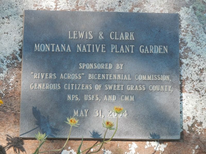
Photographed by Barry Swackhamer, July 23, 2021
3. Lewis & Clark Montana Native Plant Garden
"Rivers Across: Bicentennial Commission,
Generous Citizens of Sweet Grass County,
NPS, USFS, and CMM
May 31, 2004
Also see . . . Plants -- Discovering Lewis & Clark. Even on the toughest days of the expedition, Lewis somehow found time to observe plants along the way. However, his major periods of systematic work evidently were at Fort Mandan, Fort Clatsop, and Camp Chopunnish. (Submitted on January 27, 2022, by Barry Swackhamer of Brentwood, California.)

Photographed by Barry Swackhamer, July 23, 2021
4. Lewis & Clark Montana Native Plant Garden
Credits. This page was last revised on January 27, 2022. It was originally submitted on January 27, 2022, by Barry Swackhamer of Brentwood, California. This page has been viewed 294 times since then and 24 times this year. Photos: 1, 2, 3, 4. submitted on January 27, 2022, by Barry Swackhamer of Brentwood, California.
