Near Livingston in Park County, Montana — The American West (Mountains)
Captain Clark and the Corps of Discovery on the Yellowstone
Inscription.
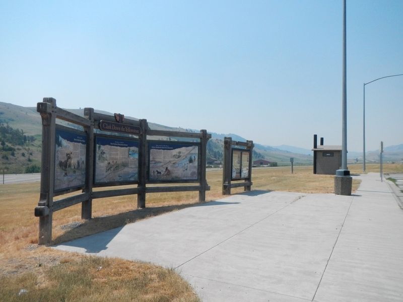
(Three panels make up this marker:)
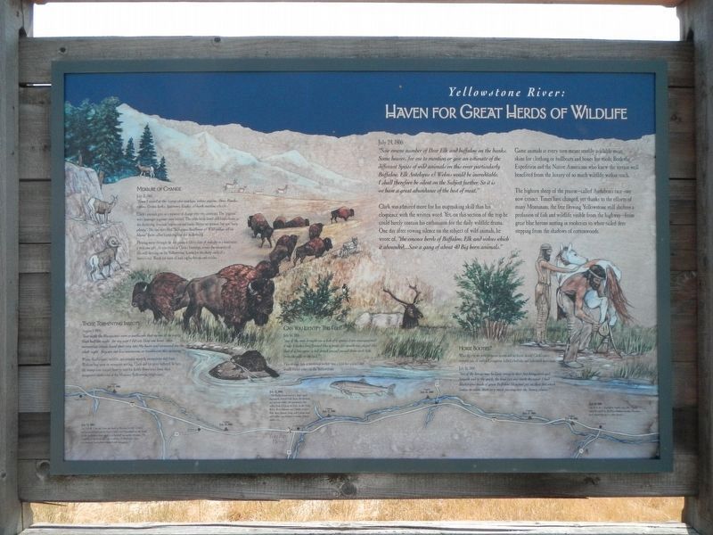
Haven for Great Hers of Wildlife
July 24, 1806
"Saw emenc number of Deer Elk and buffalow on the banks. Some beaver...for me to mention or give an estimate of the different Species of wild animals on this river particularly Buffalow, Elk Antelopes & Wolves would be increditable. I shall therefore be silent on the Subject further. So it is we have a great abundance of the best meat."
Clark was admired more for this mapmaking skill than his eloquence with the written word. Yet, on this section of the trip he could barely contain his enthusiasm for the daily wildlife drama. One day after vowing silence on the subject of wild animals, he wrote of. "the emence herds of Buffalow, Elk and wolves which it abounded,...Saw a gang of abut 40 Big horn animals."
Game animals at every turn meant readily available meat, skins for clothing or bullboats and bones for tools. Both the Expedition and the Native Americans who new the terrain well benefrited (sic) from the luxury of so much wildlife within reach.
The bighorn sheep of the prairie - called Audubon's race - are now extinct. Times have changed, yet thanks to the efforts of many Montanans, the free flowing Yellowstone still shelters a profusion of fish and wildlife visible from the highway-from great blue herons nesting in rookeries to white-tailed deer stepping from the shadows of cottonwoods.
Measure of Change
July 21, 1806
"Since I arrived at this Camp also antilops, wolves, pigions, Dovs, Hawks, ravins, Crows, larks, Sparrows, Eagles & bank martins &c. &c."
Clark's journals give us a measure of change over two centuries. The "pigions" were passenger pigeons - now extinct. The other birds listed still find a home in the sheltering, riverside vegetation and banks, Beaver are present, but not "very plenty/" He also described "Silkgrass Sunflower & Wild indigo all in blume" (now called hemp dogbane and milkvetch).
Flowing water through the dry plains is like a slant of sunlight in a rainforest-a welcome gift. As you travel in Clark's footsteps, notice the intensity of life still throwing on the Yellowstone. Listen for the sharp crack of a beaver's tail. Watch for nests of bald eagles, herons and orioles.
Those Tormenting Insects
August 1, 1806
"last night the Musquetors were so troublesom that no one of the party Slept half the night. for my part I did not Sleep one hour. those tormenting insects found their way into My beare and tormented me the whole night. they are not less noumerous or troublesom this morning."
Where there is water, wildlife and summer warmth, mosquitoes will feast. Without bug spray or mosquito netting, Clark and his party suffered. In fact the mosquitos forced him to wait for Lewis down river from their designated rendezvous at the Missouri-Yellowstone confluence.
Can You Identify This Fish?
July 16 1806
one of the men brought me a fish of a species I am unacquainted; it was 8 inches long formed like a trout, it's mouth was placed like that of a Sturgeon a red streak passed down each Side from the gills to the tail."
This strange fish-a mountain sucker was a first for science and is still found on the Yellowstone.
Horse Booties?
What do you do with footsore horsed and no horse shoes? Clark's party stopped east of today's Livingston, killed a buffalo, and fashioned moccasins.
July 16, 1806
"two of the horses was So lame owing to their feet being worn quit Smooth and to the quick, the hind feet was much the worst I had Mockersons made of free Buffalow Skin and put on their feet which Seams to releve them very much passing over the Stoney plains."
(Illustrated map of the Yellowstone River across the bottom, July 13-18, 1806:)
July 13, 1806
"at 5. P. M I Set out from the head of Missouri at the 3 forks, and proceded on nearly
East 4 miles and Encamped on the bank of Gallitines River which is a butifull navigable Stream....The Country in the forks between Gallitins & Madisens rivers is a butifull leavel plain Covered with low grass.... "
July 15, 1806
"The Roche passed out of a high rugid mountain covered with Snow. the bottoms are narrow within the mountains but widen from ½ a m. to 2 ms. in the Vally below, those bottoms are Subject to over flow, they contain Some tall Cotton wood, and willow rose bushes & rushes Honey suckle &c...."
July 18, 1806
"at 11 A. M. I observed a Smoke rise to the S. S. E in the plains towards the termonation of the rocky mountains in that direction (which is Covered with Snow) this Smoke must be raisd. by the Crow Indians in that direction as a Signal for us, or other bands."
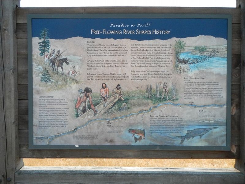
Free-Flowing River Shapes History
July 13, 1806
"I observe Several leading roads which appear to pass a gap of the mountain in a E.N.E. direction about 18 or 20 miles distant. The indian woman who has been of great Service to me as a pilot through this country recommends a gap in the mountain more South which I shall cross.-"
As Captain William Clark and his party of 12 looked down on the valley in front of you. perhaps their hearts
beat a little faster. What lay ahead on the Yellowstone River? Would they find a paradise or peril"
Following the advice of Sacagawea, Clark led his party of 12 plus 49 horses and a colt across the Bozeman pass on July 15, 1806. They followed a well-traveled "old buffalow road" to meet the Yellowstone River near present day Livingston. Twelve days earlier, Captain. Meriwether Lewis and Clark had divided forces at Traveler's Rest (near Lolo, Montana). Lewis headed northeast to explore the Marias River and Clark trekked through familiar territory until he reached the headwaters of the Missouri at Three Forks on July 13th. There, he splits his party, sending Captain (sic) Ordway and 10 men down the Missouri to meet up with Lewis. They all would converge on August 12th, downstream from the confluence of the Missouri and Yellowstone River.
Today, you can follow Clark's route along the longest, free-flowing river in the lower 48 states. Consider how this powerful river shaped their journey as it continues to influence the lives of wildlife and people today.
Cottonwood Quest
Today, big, water-loving cottonwoods are easy to find along the Yellowstone River, offering many candidates for dugout canoes. Irrigation keeps water levels from flooding and the banks are stabilized to prevent erosion. This saves the old trees, but prevents regenerating as many new seedlings.
In Clark't time, frequent floods soured the riverbank creating seedbeds for new cottonwoods but eliminating the oldest trees. Day after day, searching along the Yellowstone for cottonwoods large enough to build canoes proved futile for Clark and his party. "...no timber on tis part of the Rochjbone sufficiently large for a Canoe and time is precious...it is our wish to get to the U States this Season...."
Finally on July 20, Clark gave up the search for large trees and used several smaller ones to craft canoes. "I determined to have two Canoes made out of the largest of those trees and lash them together which will Cause then to be Study and fully Sufficient to take my Small party & Self with what little baggage we have down this river.."
As the Land Changes, So Does the River
As you follow the Yellowstone River south of Livingston past Paradise Valley, you have a chance to practice the keen observation that became the hallmark of the Lewis and Clark Expedition. Along the river's more than 600-mile journey to the Missouri, the landscape changes the the river and the river shapes the land. The icy mountain stream first rushes through Yellowstone National Park and into the Paradise Valley. Cool waters sustain healthy populations of Yellowstone cutthroat trout. The river warms up as it meanders across level plains and supports the ancient paddlefish, the sauger and pallid sturgeon. Note, too, how the trees change from evergreens in the mountains to cottonwoods and willows in the valleys, then finally to ash trees near the North Dakota border.
River of Plenty, River of Trials
August 3, 1806
"The Rochejbone or Yellow Stone river is large and navagable with but few obstructions quite into the rocks mountains...The Country through which it passes from those Mounts to its junction is Generally fertile rich open plains..."
As you travel in Clark's footsteps, notice the lush green banks contrasting with dry hillsides, the braided channels, islands and leisurely course of the Yellowstone. This life giving river assured plenty of game for the explorers to eat, fresh water to drink, and most importantly would convey them downstream in dugout canoes eventually. But the river of abundance could be maddening. They lost all their horses to the Crow Indians. Mosquitos tortured them, bison swimming across held them up for hours and an injured party member (Gibson) to the trials.
(Illustrated map of the Yellowstone River across the bottom, July 19-27, 1806:)
July 24, 1806
"on this Island I observd a large lodge...It is Situated in the Center of a butifull Island thinly Covered with Cotton wood under which the earth which is rich is Covered with wild rye and a Species of grass resembling the bluegrass, [and a mixture of Sweet grass which the Indian plat and ware around their necks for its cent which is of a Strong sent like that of the Vinella after Dinner"
July 25, 1806
I proceeded on after the lay a little and at 4 P M arived at a remarkable rock Situated in an extensive bottom on the Stard. Side of the river & 250 paces from it. this rock I ascended and from it's top had a most extensive view in every direction. This rock which I shall Call Pompy's Tower"
July 26, 1806
The bottoms of the Big Horn river are... it is very long and Contains a great perpotion of timber on which there is a variety of wild animals, perticularly the big horn which are to be found in great numbers on this river. Buffalow, Elk, Deer and Antelopes are plenty and the river is Said to abound in beaver. it is inhabited by a great number of roveing Indians..."
July 27, 1806
The Buffalow and Elk is estonishingly noumerous on the banks of the river on each Side, particularly the Elk which lay on almost every point in large gang and are So jintle that we frequently pass within 20 or 30 paces of them without their being the least alarmd.
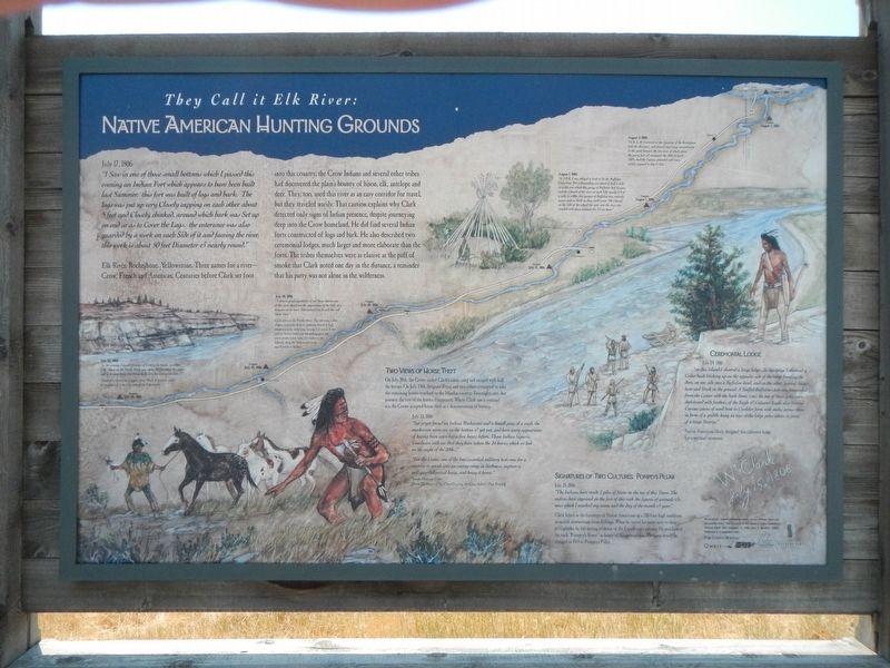
Native American Hunting Grounds
July 17, 1806
"I Saw in one of those Small bottoms which I passed this evening an Indian fort which appears to have been built last Summer. this fort was built of logs and bark. the logs was put up very Closely capping on each other about 5 feet and Closely chinked. around which bark was Set up on end so as to Cover the Logs. the enterance was also guarded by a work on each Side of it and faceing the river. this work is about 50 feet Diameter & nearly round."
Elk River, Rochjhone, Yellowstone. Three names for a river-Crow, French and American. Centuries before Clark set foot into this country, the Crow Indians and several other tribes had discovered the plain's bounty of bison, elk, antelope and deer. They, too, used this river as an easy corridor for travel, but they traveled warily. That caution explains why Clark detected only sigs of Indian presence, despite journeying deep into the Crow homeland. He did find several Indian forts constructed of logs and bark. He also described two ceremonial lodges, much larger and more elaborate than the forts. The tribes themselves were as elusive as the puff of smoke Clark noted one day in the distance, a reminder that his party was not alone in the wilderness.
Two Views of Horse Theft
On July 20th, the Crow raided Clark's canoe camp and escaped with half the horses. On July 12th, Sergeant Pryor and two others attempted to take the remaining horses overland to the Mandan country. Two nights into that journey, the rest of the horses disappeared. Where Clark saw a criminal act, the Crow accepted horse theft as a demonstration of bravery.
July 23, 1806
"Sgt. pryor found an Indian Mockerson and a Small piece of a roab, the mockerson worn out on the bottom & yet wet, and have every appearance of haveing been worn but a fiew hours before. those Indian Signs is Conclusive with me that they have taken the 24 horses which we lost on the night of the 20th..."
(From The Heart of the Crow Country: the Crow Indians Own Story)
"For the Crows, one of the four essential military tests was for a warrior to sneak into an enemy camp in darkness, capture a well-guarded prized horse, and bring it home."
Signatures of Two Cultures: Pompeys Pillar
July 25, 1806
"The Indians have made 2 piles of Stone on the top of this Tower. The nativs have ingraved on the face of this rock the figures of animals &c. near which I marked my name and the day of the month & year."
Clark hiked in the footsteps of Native Americans up a 200-foot high sandstone monolith downstream from Billings. When he carved his name next to their petroglyphs, he left lasting evidence of the Expedition's journey. He proclaimed the rock "Pompey's Tower" in honor of Sacagawea's son, The name would be changed in 1841 to Pompeys Pillar.
Ceremonial Lodge
July 24, 1806
"on this Island I observd a large lodge...in this Lodge I observed a Cedar bush Sticking up on the opposit side of the lodge fronting the dore, on one side was a Buffalow head, and on the other Several Sticks bent and Stuck in the ground. a Stuffed Buffalow skin was Suspended from the Center with the back down. (on) the top of those poles were deckerated with feathers of the Eagle & Calumet Eagle also Several Curious pieces of wood bent in Circleler form with sticks across them in form of a griddle hung on tops of the lodge poles others in form of a large Sturrip."
Native Americans likely designed this ceremonial lodge for a spiritual ceremony.
(Illustrated map of the Yellowstone River diagonally across the marker, July 28-Aug. 3, 1806:)
July 28, 1806
" in the evening I passd. Straters of Coal in the banks on either Side those on the Stard. Bluffs was about 30 feet above the water and in 2 vanes from 4 to 8 feet thick, in a horozontal position."
July 30, 1806
"I observe great quantities of red Stone thrown out of this river that from the appearance of the hills at a distance on its lower Side induced me to call this red Stone river."
Clark refers to the Powder River. The red stone called shaker is actually shale or sandstone heated to high temperatures by underlying burning coal seams. It was used by Native Americans for making spear and arrow points. Look today for shaker in the hillside along the Yellowstone form near Forsyth to Sydney.
August 1, 1806
"at 2 P. M. I was obliged to land to let the Buffalow Cross over. not withstanding an island of half a mile in width over which this gangue of Buffalow had to pass and the Chanel of the river on each Side nearly ¼ of a mile in width, this gangue of Buffalow was entirely across and as thick as they could Swim. the Chanel on the Side of the island the went into the river was crouded with those animals for ½ an hour."
August 3, 1806
"at 8. A. M. I arived at the Junction of the Rochejhone with the Missouri, and formed my Camp imediately in the point between the two river at which place the party had all encamped the 26th of April—1805....had the Canoes unloaded and every article exposed to dry & Sun.
Erected by Park County Montana, Qwest, Montana Dept. of Transportation,.
Topics. This historical marker is listed in these topic lists: Exploration • Native Americans • Natural Features • Waterways & Vessels. A significant historical date for this entry is July 13, 1806.
Location. 45° 39.689′ N, 110° 42.025′ W. Marker is near Livingston, Montana, in Park County. Marker is on Interstate 90 at milepost 325, on the right when traveling east. The marker is located at a roadside pull-out off of Interstate 90 eastbound. Touch for map. Marker is in this post office area: Livingston MT 59047, United States of America. Touch for directions.
Other nearby markers. At least 8 other markers are within 7 miles of this marker, measured as the crow flies. Legacy of Lewis and Clark: Opening the Yellowstone Corridor (here, next to this marker); Entering the Yellowstone Valley (approx. 5.2 miles away); Bozeman Pass (approx. 5.2 miles away); Livingston Memorial Hospital (approx. 6.4 miles away); Livingston Westside Residential Historic District (approx. 6.6 miles away); First Lewis and Clark Trail Marker (approx. 6.6 miles away); The Lewis & Clark Expedition (approx. 6.6 miles away); "...high rugid mountain..." (approx. 6.6 miles away). Touch for a list and map of all markers in Livingston.
Credits. This page was last revised on February 13, 2022. It was originally submitted on February 11, 2022, by Barry Swackhamer of Brentwood, California. This page has been viewed 176 times since then and 19 times this year. Photos: 1, 2, 3, 4. submitted on February 12, 2022, by Barry Swackhamer of Brentwood, California.


