Hayes in Gloucester County, Virginia — The American South (Mid-Atlantic)
Authority and Ceremony
Machicomoco State Park
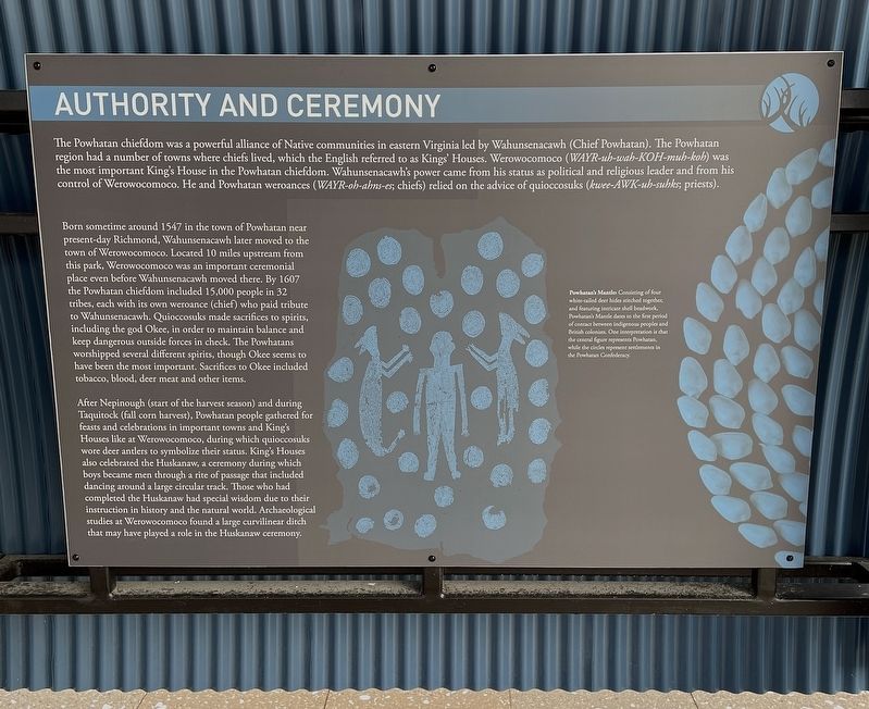
The Powhatan chiefdom was a powerful alliance of Native communities in eastern Virginia led by Wahunsenacawh (Chief Powhatan). The Powhatan region had a number of towns where chiefs lived, which the English referred to as Kings’ Houses. Werowocomoco ( WAYR-uh-wah-KOh-muh-koh ) was the most important King’s House in the Powhatan chiefdom. Wahunsenacawh’s power came from his status as political and religious leader and from his control of Werowocomoco. He and Powhatan weroances ( WAYR-oh-Ann’s-es; chiefs) relied on the advice of quioccosuks (kwee-AWK-uh-suhks; priests).
Born sometime around 1547 in the town of Powhatan near present-day Richmond. Wahunsenacawh later moved to the town of Werowocomoco. Located 10 miles upstream from this park, Werowocomoco was an important ceremonial place even before Wahunsenacawh moved there. By 1607 the Powhatan chiefdom included 15,000 people in 32 tribes, each with its own weroance (chief) who paid tribute to Wahunsenacawh. Quioccosuks made sacrifices to spirits, including the god Okee, in order to maintain balance and keep dangerous outside forces in cheek. The Powhatans worshiped several different spirits, though Okee seems to have been the most important. Sacrifices to Okee included tobacco, blood, deer meat and other items.
After Nepinough (start of the harvest season) and during Taquitock (fall corn harvest), Powhatan people gathered for feast and celebrations in important towns and King’s Houses like at Werowocomoco, during which quioccosuks wore deer antlers to symbolize there status. King’s Houses also celebrated the Hushanaw, a ceremony during which boys became men through a rite of passage that included dancing around a large circular track. Those who had completed the Huskanaw had special wisdom due to their instruction in history and the natural world. Archaeological studies at Werowocomoco found a large curvilinear ditch that may have played a role in the Huskanaw ceremony.
Powhatan’s Mantle: Consisting of four white-tailed deer hides stitched together, and featuring intricate shell beadwork, Powhatan’s Mantle dates to the first period of contact between indigenous peoples and British colonists. One interpretation is that the central figure represents Powhatan, while the circles represent settlements in the Powhatan Confederacy.
Topics. This historical marker is listed in these topic lists: Agriculture • Anthropology & Archaeology • Horticulture & Forestry • Native Americans • Settlements & Settlers. A significant historical year for this entry is 1547.
Location. 37° 17.888′ N, 76° 32.199′ W. Marker is in Hayes, Virginia, in Gloucester County. Marker can be reached from Timberneck Farm Road, 0.3 miles south of Borden Road, on the right when traveling east. Located on the grounds of Machicomoco State Park. Touch for map. Marker is at or near this postal address: 3084 Timberneck Farm Rd, Hayes VA 23072, United States of America. Touch for directions.
Other nearby markers. At least 8 other markers are within walking distance of this marker. Peacemaking and Mobility (here, next to this marker); Managing a Dynamic Landscape (here, next to this marker); Persistence (a few steps from this marker); History and Community (a few steps from this marker); The Algonquian Landscape (a few steps from this marker); Timberneck House Renovation at Machicomoco State Park (about 300 feet away, measured in a direct line); Early Timberneck Graveyard (about 300 feet away); Powhatan’s Chimney (approx. half a mile away). Touch for a list and map of all markers in Hayes.
Also see . . .
1. Virginia’s Machicomoco State Park—A “Special Meeting Place”. (Submitted on February 14, 2022, by Brandon D Cross of Flagler Beach, Florida.)
2. Machicomoco State Park. (Submitted on February 14, 2022, by Brandon D Cross of Flagler Beach, Florida.)
Credits. This page was last revised on February 15, 2022. It was originally submitted on February 14, 2022, by Brandon D Cross of Flagler Beach, Florida. This page has been viewed 140 times since then and 15 times this year. Photos: 1, 2. submitted on February 14, 2022, by Brandon D Cross of Flagler Beach, Florida. • Devry Becker Jones was the editor who published this page.

