Hayes in Gloucester County, Virginia — The American South (Mid-Atlantic)
Peacemaking and Mobility
Machicomoco State Park
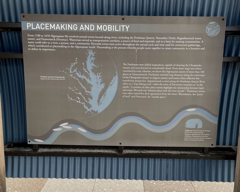
From 1100 to 1650 Algonquian life revolved around towns located along rivers, including the Powhatan (James), Pamunkey (York), Rappahanock (same name), and Patawomeck (Potomac). Waterways served as transportation corridors, a source of food and materials, and as a basis for naming communities. A name could refer to a river, a person, and a community. Riverside towns were active throughout the annual cycle and were used for ceremonial gatherings, which contributed to placemaking in the Algonquian world. Placemaking is the process whereby where people come together to create community in a location and to define its importance.
The Powhatans were skilled mapmakers, capable of charting the Chesapeake estuary and areas beyond in considerable detail. From these maps and others translated by early colonists, we know the Algonquian names of more than 100 places in Tsenacomacoh. Powhatans traveled long distances along the waterways of the Chesapeake estuary in dugout canoes, and names often reflected this waterborne perspective. Appamattuck, a town along the Powhatan (James) River refers to a “trap-fishing river,” while the town of Pawtuxent translates as “at the rapids.” A number of other place names highlight the relationship between land and water: Winsack was “pleasant place near the river mouth.” Prominent towns were often named for the appearance from the water: Warraskoyac, the “point of land” and Pissacoack, the “muddy place.”
Longhouses: Historical residential dwellings built by Native people including Algonquian-speaking tribes in the Powhatan Confederacy. Sharpened poles and woven strips of bark were used to make the curvilinear frames and waterproof cladding.
Erected 2021 by State of Virginia.
Topics. This historical marker is listed in these topic lists: Anthropology & Archaeology • Native Americans • Settlements & Settlers • Waterways & Vessels. A significant historical year for this entry is 1100.
Location. 37° 17.889′ N, 76° 32.198′ W. Marker is in Hayes, Virginia, in Gloucester County. Marker can be reached from Timberneck Farm Road, 0.3 miles south of Borden Road, on the right when traveling east. The marker is located on the grounds of Machicomoco State Park. Touch for map. Marker is at or near this postal address: 3084 Timberneck Farm Rd, Hayes VA 23072, United States of America. Touch for directions.
Other nearby markers. At least 8 other markers are within walking distance of this marker. Managing a Dynamic Landscape (here, next to this marker); Authority and Ceremony (here, next to this marker); History and Community (here, next to this marker); The Algonquian Landscape (a few steps from this marker); Persistence (a few steps from this marker); Timberneck House Renovation at Machicomoco State Park (about 300 feet away, measured in a direct line); Early Timberneck Graveyard (about 300 feet away); Powhatan’s Chimney (approx. half a mile away). Touch for a list and map of all markers in Hayes.
Also see . . .
1. Virginia’s Machicomoco State Park—A “Special Meeting Place”. (Submitted on February 16, 2022, by Brandon D Cross of Flagler Beach, Florida.)
2. Machicomoco State Park. (Submitted on February 16, 2022, by Brandon D Cross of Flagler Beach, Florida.)
Credits. This page was last revised on February 16, 2022. It was originally submitted on February 16, 2022, by Brandon D Cross of Flagler Beach, Florida. This page has been viewed 88 times since then and 12 times this year. Photos: 1, 2. submitted on February 16, 2022, by Brandon D Cross of Flagler Beach, Florida. • Devry Becker Jones was the editor who published this page.

