Florida Heights in Atlanta in Fulton County, Georgia — The American South (South Atlantic)
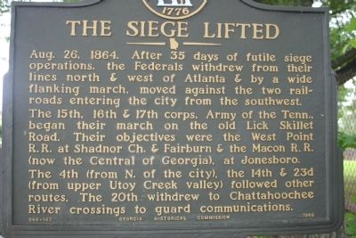
The Siege Lifted
Photographed by Mrs. Sarahlyn Davies Bennett, May 10, 2009
1. The Siege Lifted Marker
Looking South with Westview Cemetery in the background
The 15th, 16th, & 17th corps, Army of the Tenn., began their march on the old Lick Skillet Road. Their objectives were the West Point R.R. at Shadnor Ch. & Fairburn & the Macon R.R. (now the Central of Georgia), at Jonesboro.
The 4th (from N. of the city), the 14th & 23d (from upper Utoy Creek valley) followed other routes. The 20th withdrew to Chattahoochie River crossings to guard communications.
Erected 1958 by Georgia Historical Commission. (Marker Number 060-163.)
Topics and series. This historical marker is listed in this topic list: War, US Civil. In addition, it is included in the Georgia Historical Society series list. A significant historical date for this entry is August 26, 1913.
Location. Marker has been reported missing. It was located near 33° 45.01′ N, 84° 27.389′ W. Marker was in Atlanta, Georgia, in Fulton County. It was in Florida Heights. It was on Martin Luther King Jr. Drive (Former Gordon Road)
this page online

Regionally, this marker was in Georgia’s Piedmont. It was also in the American South and specifically in the Deep South. Globally, it was in North America, the Western Hemisphere, the Western World, and the Anglosphere. Historically, it found itself in what was once the territory of the Mississippian Culture, one of the original Thirteen Colonies, one of the Confederate States of America, and the Antebellum South.
Other nearby markers. At least 8 other markers are within walking distance of this location: Battlefield of Ezra Church (approx. ¼ mile away); Battle of Ezra Ch. (approx. 0.4 miles away); William L. Scruggs L.L.D. (approx. half a mile away); a different marker also named Battle of Ezra Ch. (approx. 0.6 miles away); a different marker also named Battle of Ezra Ch. (approx. 0.6 miles away); Westview Receiving Vault
Photographed by David Seibert, September 22, 2010
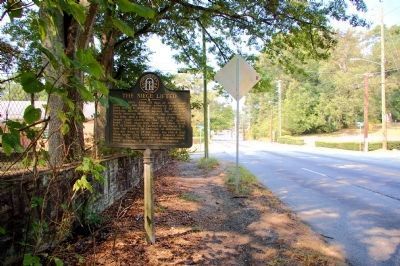
2. The Siege Lifted Marker
Looking west on Martin Luther King Jr Drive; Westview Cemetery is to the left.
Another marker is no longer nearby. Lick Skillet Road (was approx. half a mile away but has been confirmed missing).
More about this marker. Marker was written and submitted by Mr. Wilbur Kurtz, Historian and Artist and member of the Atlanta Historical Society in preparation for the Civil War Centennial
Regarding The Siege Lifted. Sherman's Flanking Movement of Atlanta
Related markers. Click here for a list of markers that are related to this marker. Follow the Route by way of markers.
Additional keywords. Union Army Flanking Movement August 26-30, 1864
Credits. This page was last revised on February 8, 2023. It was originally submitted on May 10, 2009, by Lieutenant Colonel Perry Bennett, Army Historian of Atlanta, Georgia. This page has been viewed 1,466 times since then and 25 times this year. Last updated on February 21, 2022, by Thomas Cole of Marietta, Georgia. Photos: 1. submitted on May 10, 2009, by Lieutenant Colonel Perry Bennett, Army Historian of Atlanta, Georgia. 2. submitted on September 23, 2010, by David Seibert of Sandy Springs, Georgia. • Bernard Fisher was the editor who published this page.
