Annapolis in Anne Arundel County, Maryland — The American Northeast (Mid-Atlantic)
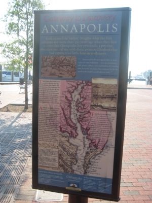
Gateway to Discovery
Annapolis
"...heaven and earth never agree better to frame a place for mans habitation...here are mountaines, hills, plaines, valleyes, rivers and brookes, all running most pleasantly into a faire Bay compassed but for the mouth with fruitfull an delightsome land." - Captain John Smith, 1612
The first Europeans to settle in this area were dissident Protestants from Virginia who arrived in 1649. They named the area Providence and initially took up land on the north shore of the Severn River. They soon spread themselves out along nearby creeks to obtain sufficient land for raising tobacco, their primary crop. Within a few years, the first settlers had established plantations on this peninsula.
A small hamlet, known first as Arundelton and then as Ann Arundell Town, had develped on the land along Spa Creek by the end of the seventeenth century. In 1695, the capital of Maryland's colonial government moved from St. Mary's City to the fledgling town, which was soon renamed Annapolis to honor the future Queen Anne of England. Over the next fifty years, Annapolis developed into an active seaport. Ships departed with cargoes of colonial crops for trace overseas, while others arrived carrying manufactured goods and foodstuffs from all parts of the globe, as well as immigrants from Europe and slaves from Africa and the West Indies.
The Bay's network of rivers and creeks has provided an accessible means of travel and trade for centuries. Prior to the arrival an dsettlement of people from Europe, local Native American tribes lived, fished, and traded with one another along the tributaries of the Bay's western shore. Crabs, terrapin, oysters, eels and fish pulled from the bountiful Bay supplemented their diet of corn, beans, squash, sunflowers, berries, nuts, wild birds, and game.
[inset] Annapolis.
Last week arrived in Town, to regulate and settle the Affairs of the Post Office, BENJAMIN FRANKLIN, Esq. of Philadelphia, and WILLIAM HUNTER, Esq. of Williamsburg, his Majesty's Post Masters General of the Continent of North America.
Capt. Rawlins, from London, is arrived in Virginia.
Custom House, Annapolis, January 3.
Sloop Joanna, Patrick Keating, from Boston;
Schooner Braidalmin, Haines, from Philadelphia;
Brig Endeavour, John Jones, from Barbadoes;
Schooner John and Franc's, Freeborn Groves, from Salem;
Schooner Mermaid, Job Dresen, from Halifax;
Snow Molly, William Smith, from Bristol;
Snow Peggy, William Wallace, from Barbadoes.
Learn More About Annapolis
Pick up information about other Annapolis sites at the nearby Information Center or at the Visitor Center at 26 West Street.
The Annapolis, London Town and South County Heritage Area, Annapolis Maritime Museum, Historic Annapolis Foundation, The Eastport Walking Tour.
Acknowledgements
City of Annapolis, Hartge Nautical Museum, Historici Annapolis Foundation, Johns Hopkins University, M.E. Warren, Maryland Historical Society, Maryland State Archives, National Park Service.
Designers: Peter D. Tasi & Assoc., Gerard Valerio, Terry Peterson.
Erected by Chesapeake Bay Gateways Network.
Topics. This historical marker is listed in these topic lists: African Americans • Colonial Era • Exploration • Industry & Commerce • Native Americans • Settlements & Settlers. A significant historical date for this entry is January 3, 1991.
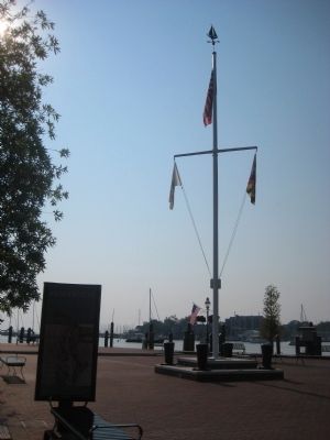
Location. 38° 58.591′ N, 76° 29.09′ W. Marker is in Annapolis, Maryland, in Anne Arundel County. Marker can be reached from Dock Street, 0.1 miles Market Space when traveling east. Marker is on the plaza beyond the parking lot. Touch for map. Marker is in this post office area: Annapolis MD 21401, United States of America. Touch for directions.
Other nearby markers. At least 8 other markers are within walking distance of this marker. Maritime Annapolis: An Enduring Legacy (here, next to this marker); Watermen and Working Harbor (a few steps from this marker); Transportation on the Chesapeake Highway (a few steps from this marker); Steamboats Give Way to the New Bay Bridge (a few steps from this marker); Annapolis: Capital of Commerce (a few steps from this marker); Commodore John Barry (within shouting distance of this marker); Annapolis Depicted (about 400 feet away, measured in a direct line); Sy Mohr's City Dock Harbormaster Collage (about 400 feet away). Touch for a list and map of all markers in Annapolis.
Credits. This page was last revised on June 16, 2016. It was originally submitted on May 22, 2009, by F. Robby of Baltimore, Maryland. This page has been viewed 913 times since then and 13 times this year. Photos: 1, 2. submitted on May 22, 2009, by F. Robby of Baltimore, Maryland.

