Hastings-on-Hudson in Westchester County, New York — The American Northeast (Mid-Atlantic)
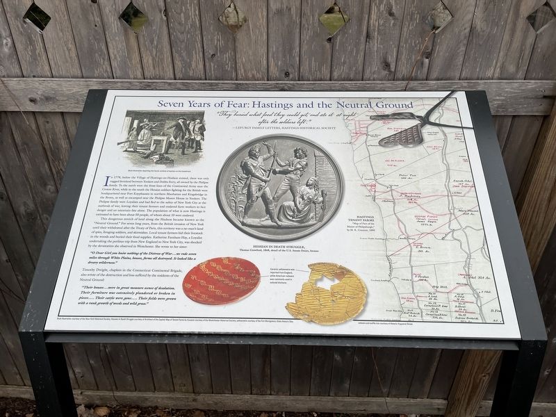
Seven Years of Fear: Hastings and the Neutral Ground

Photographed By Devry Becker Jones (CC0), March 6, 2022
1. Seven Years of Fear: Hastings and the Neutral Ground Marker
"They buried what food they could get, and ate it at night after the soldiers left."
—Lefurgy family letters, Hastings Historical Society
In 1778, before the Village of Hastings-on-Hudson existed, there was only rugged farmland between Yonkers and Dobbs Ferry, all owned by the Philipse family. To the north were the front lines of the Continental Army near the Croton River, while to the south the Hessian soldiers fighting for the British were headquartered near Fort Knyphausen in northern Manhattan and Kingsbridge in the Bronx, as well as encamped near the Philipse Manor House in Yonkers. The Philipse family were Loyalists and had fled to the safety of New York City at the outbreak of war, leaving their tenant farmers and enslaved farm workers to face the danger and uncertain fate alone. The population of what is now Hastings is estimated to have been about 50 people, of whom about 10 were enslaved.
This dangerous stretch of land along the Hudson became known as the "Neutral Ground." For seven long years, from the British invasion of New York until their withdrawal after the Treaty of Paris, this territory was a no-man's-land of spies, foraging soldiers, and skirmishes. Local tenant farmers hid their livestock in the woods and buried their food supplies. Katherine Farnham Hay, a Loyalist undertaking the perilous trip from New England to New York City, was shocked by the devastation she observed in Westchester. She wrote to her sister:
"O Dear Girl you know nothing of the Distress of War…we rode seven miles through White Plains, houses, farms all destoeyd. It looked like a dreary wilderness."
Timothy Dwight, chaplain in the Connecticut Continental Brigade, also wrote of the destruction and loss suffered by the residents of Neutral Ground:
"Their houses…were in great measure scenes of desolation. Their furniture was extensively plundered or broken in pieces.... Their cattle were gone.... Their fields were grown with a rank growth of weeds and wild grass."
[Caption:]
Ceramic yellowware was imported from England, while American redware was commonly used in colonial kitchens.
Topics. This historical marker is listed in these topic lists: African Americans • Anthropology & Archaeology • War, US Revolutionary • Women. A significant historical year for this entry is 1778.
Location. 40° 59.884′ N, 73° 52.904′ W. Marker is in Hastings-on-Hudson, New York, in Westchester County. Marker is at the intersection of Warburton Avenue and Broadway (U.S. 9), on the

Photographed By Devry Becker Jones (CC0), March 6, 2022
2. Seven Years of Fear: Hastings and the Neutral Ground Marker
Other nearby markers. At least 8 other markers are within walking distance of this marker. The American Revolution in 1778 (here, next to this marker); Washington's Continental Army (here, next to this marker); The Hessians: Hired by the King (here, next to this marker); The Battle of Edgar's Lane (here, next to this marker); After the Battle (here, next to this marker); The Skirmish of Edgar's Lane (a few steps from this marker); Community Gardens in Zinsser Park / Los Jardines Comunitarios en el Parque Zinsser (a few steps from this marker); a different marker also named Battle of Edgar's Lane (within shouting distance of this marker). Touch for a list and map of all markers in Hastings-on-Hudson.
Credits. This page was last revised on March 12, 2022. It was originally submitted on March 12, 2022, by Devry Becker Jones of Washington, District of Columbia. This page has been viewed 139 times since then and 12 times this year. Photos: 1, 2. submitted on March 12, 2022, by Devry Becker Jones of Washington, District of Columbia.