Downtown Eastside in Blacksburg in Montgomery County, Virginia — The American South (Mid-Atlantic)
Westview Cemetery
Confederate and Union Burial Ground
Photographed by Bernard Fisher, June 26, 2015
1. Westview Cemetery Marker
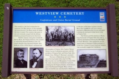
Notable veterans resting here include Dr. Harvey Black, 4th Virginia Infantry, who assisted in amputating Stonewall Jackson’s arm; Col. Charles Ronald of the Stonewall Brigade; John McBryde of Gen. J.E.B. Stuart’s command and 5th president of Virginia Tech; Captain Thomas Nelson Conrad, Confederate spymaster and 3rd president of Virginia Tech; and Union Capt. John Brady of Gen. William T. Sherman’s command.
The town of Blacksburg, just west of here, was a thriving hamlet before the Civil War. Men from the town and Montgomery County filled the ranks of numerous Confederate regiments, including the 4th Virginia Infantry, which became part of the Stonewall Brigade. Many of those men survived the war and returned to Blacksburg to take part in the region’s postwar recovery. Many other Confederate and Union veterans gravitated to Blacksburg after the
this page online
The Preston and Olin Institute in Blacks- burg (forerunner of Virginia Tech) was used as a Federal encampment following the 1864 Battle of Cloyd’s Mountain. That engagement was the largest battle in Southwest Virginia and part of Union Gen. Ulysses S. Grant’s total war initiative that eventually crippled the Confederacy.
(captions)
(upper left) Dr. Harvey Black / Thomas Nelson Conrad
(top center) United Veterans Group from Blacksburg, ca. 1901
(lower right) Preston and Olin Institute, 1870 All images courtesy Virginia Tech
Erected by Virginia Civil War Trails.
Topics and series. This historical marker is listed in these topic lists: Cemeteries & Burial Sites • Education • War, US Civil. In addition, it is included in the Virginia Civil War Trails series list. A significant historical year for this entry is 1864.
Location. 37° 14.054′ N, 80° 24.455′ W. Marker is in Blacksburg, Virginia, in Montgomery County. It is in Downtown Eastside. It can be reached from the intersection of Owens Street and East Roanoke Street, on the right when traveling
Photographed by Bernard Fisher, June 26, 2015
2. Westview Cemetery Marker

Regionally, this marker is in Southwest Virginia, in the Blue Ridge Highlands, and in the New River Gorge. It is also in the American South, specifically in the Upper South, in Appalachia, and specifically in Southern Appalachia. Globally, it is in North America, the Western Hemisphere, the Western World, and the Anglosphere. Historically, it finds itself in what was once the territory of the Mississippian Culture, one of the original Thirteen Colonies, one of the Confederate States of America, and the Antebellum South.
Other nearby markers. At least 8 other markers are within walking distance of this marker: To the Memory of the Confederate Dead (within shouting distance of this marker); The Cellar Building (approx. half a mile away); William Black (approx. half a mile away); Virginia Polytechnic Institute and State University (approx. half a mile away); People and Place / Land Grant College (approx. half a mile away); The Early Years / Campus Over Time (approx. half
Photographed by Bernard Fisher, June 26, 2015
3. Westview Cemetery Marker
Credits. This page was last revised on April 29, 2026. It was originally submitted on June 27, 2015, by Bernard Fisher of Richmond, Virginia. This page has been viewed 1,668 times since then and 86 times this year. Last updated on March 21, 2022, by Drew A Gruber of N/a, N/a. Photos: 1, 2, 3. submitted on June 27, 2015, by Bernard Fisher of Richmond, Virginia. • J. Makali Bruton was the editor who published this page.
