Abell in Baltimore, Maryland — The American Northeast (Mid-Atlantic)
Village life goes on along Old York Road..

Photographed By Devry Becker Jones (CC0), June 11, 2023
1. Village life goes on along Old York Road.. Marker
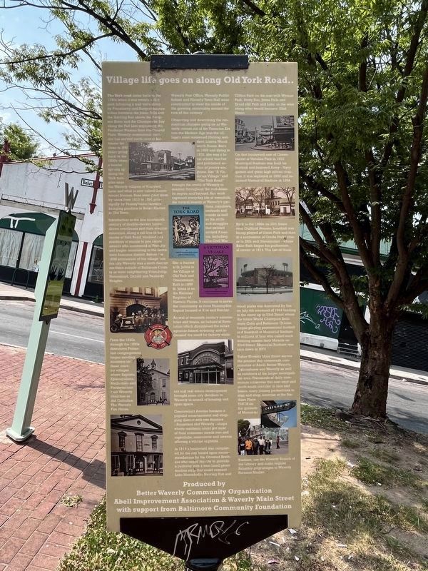
The York road dates back to the 1740s when it was merely a dirt path following a trail worn down by Piscataway and Susquehannock tribes between the Jones Falls and the Herring Run above the Patapsco River and the Chesapeake Bay along the Fall Line separating the Piedmont Plateau from the Coastal Plain. Waverly commercial corridor has served north central Baltimore for for close to 200 years going back to the 1830s when a hamlet sprung up along the York turnpike near the Waverly tollgate at Vineyard Lane and what is now called Greenmount Avenue. Fees were paid there by users from 1810 to 1894 principally by Pennsylvania farmers bringing produce to Belair Market in Old Town.
Introduction in the late nineteenth century of double-decker horse-drawn omnibuses and then electric streetcars, along a rail line in the center of York Road, enabled city residents of means to join estate owners who summered in Waverly and began commuting to the downtown business district. Before the 1888 annexation of the village into the city, Waverly was a ninth district northern suburb of Baltimore County as were neighboring Friendship, Homestead, Oxford and Peabody Heights.
From the 1840s through the 1890s downtown Protestant congregations began sending ministers into these country villages where Baptists, Episcopalians, Methodists and Presbyterians built Waverly churches as did Catholics. The Waverly Fire House, Waverly Post Office, Waverly Public School and Waverly Public School and Waverly Town Hall were constructed to meet the needs of the growing community around the turn of this century.
Observing and describing the momentous changes going on as Waverly moved out of the Victorian Era into the Modern Age was the village's most renowned lifelong resident, Lizette Woodworth Reese. Born in 1856 and dying in 1935, she was a local school teacher and published author of poetry and prose. Her "A Victorian Village" and "The York Road" brought the world of Waverly to readers throughout the mid-Atlantic region and beyond. Her work captured everyday life of townsfolk, the natural beauty of Waverly's gardens, meadows, orchards and woods as well as the strife and struggles that swirled around America, including The Civil War.
She is buried at St. Johns in the Village at Old York and Greenmount. Built in 1859 St. Johns is on the National Register of Historic Places. It continues to serve the community as does Huntingdon Baptist located at 31st and Barclay.
Arrival of twentieth century automobiles and buses, an Industrial Revolution which diminished the area's agrarian based economy and increased the need for factory workers and real estate development brought more city dwellers and

Photographed By Devry Becker Jones (CC0), June 11, 2023
2. Village life goes on along Old York Road.. Marker
Greenmount Avenue became a popular entertainment and shopping district with two theaters — Boulevard and Waverly — shops where residents could get most of their consumer needs met and nightclubs, restaurants and taverns offering a vibrant nightlife.
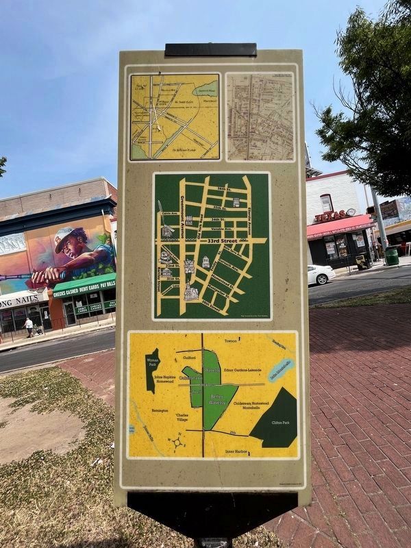
In 1919 a boulevard was completed by the city based upon recommendations by the Olmsted Brothers who urged the city to provide a parkway with a tree-lined green median strip that could connect Lake Montebello, Herring Run and Clifton Park on the east with Wyman Park, Stony Run, Jones Falls and Druid Hill Park and Lake on the west along what would become 33rd Street.
On that boulevard east of Greenmount at Venable Park in 1922 Municipal Stadium was built for football and featured the Army-Navy games and great high school rivalries. It was replaced in 1950 and renamed Memorial Stadium in 1954.
Back in the 1890s on 25th Street near Guilford Avenue, baseball was being played at Union Park and then in a succession of Oriole Parks closer to 29th and Greenmout — where Babe Ruth began his professional carer in 1914. The last of these wood parks was destroyed by fire on July 4th weekend of 1944 leading to the move up to 33rd Street where the future World Champion Baltimore Colts and Baltimore Orioles

Photographed By Devry Becker Jones (CC0), June 11, 2023
3. Village life goes on along Old York Road.. Marker
Today Waverly Main Street serves the present day crossroads communities of Abell, Better Waverly, Oakenshawe and Waverly as well as residents of the larger metropolitan areas. Thousands of daily commuters crosscross this east-west and north-south corridor in cars and buses, many joining pedestrians to stop and shop, exercise at the Stadium Place YMCA on the ground of Memorial Stadium, use the Waverly Branch of the Library and make regular Saturday pilgrimages to Waverly Farmers Market.
Erected by Better Waverly Community Organization, Abell Improvement Association & Waverly Main Street with support from Baltimore Community Foundation.
Topics. This historical marker is listed in these topic lists: Parks & Recreational Areas • Roads & Vehicles • Settlements & Settlers • War, US Civil. A significant historical date for this entry is July 4, 1810.
Location. 39° 19.705′ N, 76° 36.581′ W. Marker is in Baltimore, Maryland. It is in Abell. Marker is at the intersection of Greenmount Avenue (Maryland Route 45) and East 33rd Street, on the right when traveling south on Greenmount Avenue. Touch for map . Marker is at or near this postal address: 3300 Greenmount Ave, Baltimore MD 21218, United States of America. Touch for directions.
Other nearby markers. At least 8 other markers are within walking distance of this marker. Connection to Nature & Learning (a few steps from this marker); "Old" Oriole Park (approx. ¼ mile away); Eastern High School Monument (approx. 0.4 miles away); Memorial Field at the Y (approx. 0.4 miles away); Cal Ripken, Sr. (approx. 0.4 miles away); Homewood (approx. 0.4 miles away); World War I Memorial (approx. half a mile away); Beach (approx. half a mile away). Touch for a list and map of all markers in Baltimore.
Credits. This page was last revised on June 12, 2023. It was originally submitted on April 6, 2022, by Devry Becker Jones of Washington, District of Columbia. This page has been viewed 378 times since then and 88 times this year. Photos: 1, 2, 3. submitted on June 12, 2023, by Devry Becker Jones of Washington, District of Columbia.