Hopewell, Virginia — The American South (Mid-Atlantic)
City Point, Virginia
Photographed by Bernard Fisher, May 31, 2009
1. City Point, Virginia CWT Marker
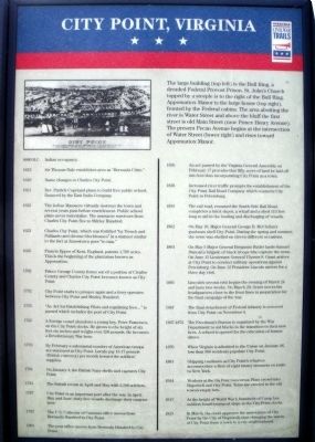
8000 — B.C. Indian occupancy.
1613 Sir Thomas Dale establishes area as “Bermuda Cittie.”
1619 — Name changes to Charles City Point.
1621 — Rev. Patrick Copeland plans to build free public school, financed by the East India Company.
1622 — The Indian Massacre virtually destroys the town and several years pass before resettlement. Public school plans never materialize. The massacre survivors from Charles City Point flee to Shirley Hundred.
1623 — Charles City Point, which was fortified “by Trench and Pallizado and diverse blockhouses” in a manner similar to the fort at Jamestown goes “to ruin.”
1635 — Francis Eppes of Kent, England, patents 1,700 acres. This is the beginning of the plantation known as Appomattox.
1702 — Prince George County forms out of a portion of Charles County and Charles City point becomes known as City Point.
1732 — City Point starts to prosper again and a ferry operates between City Point and Shirley Hundred.
1755 — “An Act for Establishing Pilots and regulating fees…” is passed which includes the port of City Point.
1765 — A foreign vessel abandons a young boy, Peter Francisco, on the
this page online
1776 — By February a substantial number of American troops are stationed at City Point. Locals pay 15-17 pounds (British currency) per month toward the soldier’s supplies.
1781 — On January 4, British Navy shells and captures City Point.
1781 — The British return in April and May with 2,500 soldiers.
1787 — City Point is an important port after the war. In April, May and June, sixty-five vessels discharge their cargoes here.
1797 — The U.S. Collector of Customs office moves from Bermuda Hundred to City Point.
1801 — The post office moves from Bermuda Hundred to City Point.
1826 — An act passed by the Virginia General Assembly on February 17 provides that fifty acres of land be laid off into lots thus incorporating City Point as a town.
1838 — Increased river traffic prompts the establishment of the City Point Rail Road Company which connects City Point to Petersburg.
1855 The rail road, renamed the South Side Rail Road, completes a brick depot, a wharf an a shed 113 feet long to aid in the loading
circa 1866
2. City Point
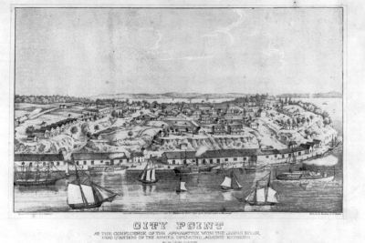
At the confluence of the Appomattox with the James River, headquarters of the armies operating against Richmond. Library of Congress [LC-USZ62-73623]
1862 — On May 19, General George B. McClellan’s gunboats shell City Point. During the spring and summer, the town was shelled on eleven different occasions.
1864 — On May 5 Major General Benjamin Butler lands Samuel Duncan’s brigade of black troops who capture the town. On June 15 Lieutenant General Ulysses S. Grant arrives at City Point to conduct military operations against Petersburg. On June [21] President Lincoln arrives for a three day visit.
1865 — Lincoln’s second visit begins the evening of March 24 and lasts two weeks. On March 29, Grant moves his headquarters close to the front lines in preparation for the final campaign of the war.
1867 — The final detachment of Federal infantry is removed from City Point on November 4.
1867-1872 — The Freedman’s Bureau is organized by the War Department to aid blacks in the transition to their new lives. A school is opened for the education of former slaves.
1870 — When Virginia is admitted to the Union on January 26, less than 300 residents populate City Point.
1881 — Shipping continues as City Point’s wharves accommodate a fleet of eight luxury steamers
Photographed by Bernard Fisher, May 31, 2009
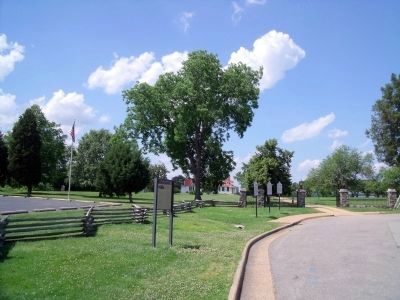
3. City Point, Virginia CWT Marker on Cedar Lane (facing north)
1914 — Workers at the Du Pont Guncotton Plant crowd into Hopewell and City Point. Tents are erected in the old town’s empty lots.
1917 — At the height of World War I, hundreds of camp Lee soldiers board transport ships at City Point docks.
1923 — In March, the court approves the annexation of City Point by the City of Hopewell, thus changing the status of City Point from a town to a city neighborhood.
Erected by Virginia Civil War Trails.
Topics and series. This historical marker is listed in these topic lists: Colonial Era • Education • Indigenous Peoples and Communities • Settlements & Settlers. In addition, it is included in the Former U.S. Presidents: #16 Abraham Lincoln, the Postal Mail and Philately, and the Virginia Civil War Trails series lists. A significant historical date for this entry is May 19, 1862.
Location. This marker has been replaced by another marker nearby. It was located near 37° 18.915′ N, 77° 16.623′ W. Marker was in Hopewell, Virginia. It was at the intersection of Cedar Lane and Pecan Avenue, on the left when traveling north on Cedar Lane. This marker is located in the City Point Unit of the Petersburg National Battlefield. Touch for map. Marker was at or near this postal address: 1000 Pecan Ave, Hopewell VA 23860, United States of America. Touch for directions.

Regionally, this marker was in Central Virginia. It was also in the American South, specifically in the Upper South, and on the Eastern Seaboard. Globally, it was in the North Atlantic Region, North America, the Western Hemisphere, the Western World, and the Anglosphere. Historically, it found itself in what was once the territory of the Mississippian Culture, one of the original Thirteen Colonies, one of the Confederate States of America, and the Antebellum South.
Other nearby markers. At least 8 other markers are within walking distance of this location: A different marker also named City Point, Virginia (here, next to this marker); a different marker also named City Point (a few steps from this marker); Appomattox Manor (a few steps from this marker); General Grant's Headquarters (a few steps from this marker); A Busy Supply Hub (within shouting distance of this marker); The Peacemaker (within shouting distance of this marker); Porter House (within shouting distance of this marker); The Depot Field Hospital (about 300 feet away, measured in a direct line). Touch for a list and map of all markers in Hopewell.
Other markers no longer nearby. City Point (was within shouting distance of this marker but has been replaced with another marker now near it); a different marker also named The Peacemaker (was within shouting distance of this marker but has been replaced with another marker now near it).
More about this marker. On the top panel is a print of City Point. It carries the caption, "The large building (top left) is the Bull Ring, a dreaded Federal Provost Prison. St. John’s Church topped by a steeple is to the right of the Bull Ring. Appomattox Manor is the large house (top right), fronted by the Federal cabins. The area abutting the river is Water Street and above the bluff the first street is old Main Street (now Prince Henry Avenue). The present Pecan Avenue begins at the intersection of Water Street (lower right) and rises toward Appomattox Manor."
Related marker. Click here for another marker that is related to this marker. New Marker At This Location also titled "City Point, Virginia".
Also see . . . Petersburg National Battlefield. City Point. (Submitted on June 4, 2009, by Bernard Fisher of Richmond, Virginia.)
Credits. This page was last revised on September 27, 2024. It was originally submitted on June 3, 2009, by Bernard Fisher of Richmond, Virginia. This page has been viewed 3,005 times since then and 108 times this year. Photos: 1. submitted on June 3, 2009, by Bernard Fisher of Richmond, Virginia. 2, 3. submitted on June 4, 2009, by Bernard Fisher of Richmond, Virginia.
