Near Brooks in Newell County, Alberta — Canada’s Prairie Region (North America)
River in the Sky
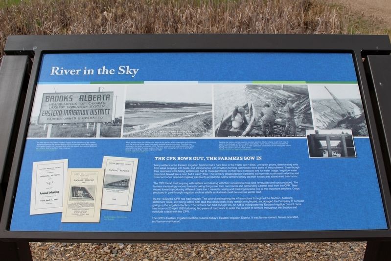
The CPR bows out, the farmers bow in
The CPR found itself arguing with settlers and dealing with their requests to have land revaluated and costs reduced. The farmers increasingly moved towards taking things into their own hands and demanding a better deal from the CPR. They moved towards producing different crops too. Livestock raising and finishing became one of the important activities. Crops produced in part through irrigation such as alfalfa and wheat could be used as winter feed.
By the 1930s the CPR had had enough. The cost of maintaining the infrastructure throughout the Section, declining settlement rates, and rising settler debt load that would most likely remain uncollected, encouraged the Company to consider giving up the irrigation Section. The farmers had had enough too. An Act to Incorporate the Eastern Irrigation District came into force on 23 April 1935 following two years of hard work to enlist the support of farmers throughout the Section and conclude a deal with the CPR.
The CPR's Eastern Irrigation Section became today's Eastern Irrigation District. It was farmer-owned, farmer-operated, and farmer-maintained.
[Photo captions (left to right)]
• An early sign for the Eastern Irrigation District. By the conditions of the transfer agreement between the farmers and the CPR, the farmers owned all the parts of the irrigation system, all the unsold land within the district, and received $300,000 as a reserve fund to start their new enterprise. Glenbow Archives, NA-3250-33
• Alkali, another name for soluble salts, seeps to the surface when evaporation pulls moisture from the land and brings water from deeply watered land to the surface. The alkali has dissolved in the water and comes with it. Farmers could not work alkali crusted land which reduced the number of arable acres on their farm. This photograph shows an attempt to remove alkali from the surface of a field in 1924. Glenbow Archives, NA-4389-23
• Keeping the system working required constant attention. Workers trying to get earth bags in place to stop leakage at the head gates to the Bantry Canal (main); a shovel excavates the Spring Hill Canal to lower the grade in 1934 (right); and construction of new head gates for the Spring Hill Canal in January, 1935 (inset). Glenbow Archives, NA-4389-24, NA-4389-44, and NA-4389-45
Erected by Agriculture and Agri-Food Canada, Agri-Environment Services Branch.
Topics. This historical marker is listed in these topic lists: Agriculture • Bridges & Viaducts • Railroads & Streetcars • Waterways & Vessels. A significant historical date for this entry is April 23, 1935.
Location. 50° 31.701′ N, 111° 51.416′ W. Marker is near Brooks, Alberta, in Newell County. Marker is on Brooks Aqueduct trail, 1.4 kilometers west of Range Road 142. Touch for map. Marker is in this post office area: Brooks AB T0J 3K0, Canada. Touch for directions.
Other nearby markers. At least 6 other markers are within walking distance of this marker. A different marker also named River in the Sky (here, next to this marker); Welcome to the Brooks Aqueduct (approx. 1.4 kilometers away); The Brooks Aqueduct/L’aqueduc de Brooks (approx. 1.4 kilometers away); a different marker also named River in the Sky (approx. 1.4 kilometers away); a different marker also named River in the Sky (approx. 1.4 kilometers away); The River Runs Dry (approx. 1.4 kilometers away).
Related markers. Click here for a list of markers that are related to this marker.
Credits. This page was last revised on May 1, 2022. It was originally submitted on May 1, 2022, by Duane and Tracy Marsteller of Murfreesboro, Tennessee. This page has been viewed 63 times since then and 2 times this year. Photo 1. submitted on May 1, 2022, by Duane and Tracy Marsteller of Murfreesboro, Tennessee.
Editor’s want-list for this marker. Wide shot of marker and surrounding area in context. • Can you help?
