Lewes in Sussex County, Delaware — The American Northeast (Mid-Atlantic)
A History of the Junction & Breakwater Railroad

Photographed By Devry Becker Jones (CC0), May 28, 2022
1. A History of the Junction & Breakwater Railroad Marker
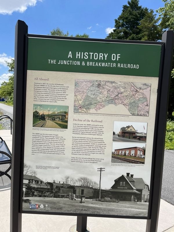
All Aboard!
Chartered in 1857, the Junction & Breakwater Railroad (J&BRR) ran the 38 miles from a junction with the Delaware Railroad in Harrington to the Delaware Breakwater in Lewes. The portion of the line from Georgetown to Lewes opened for service in 1870 and linked the established towns of Georgetown and Lewes with new, smaller communities that formed after the stations were constructed. During the late 1870s, a branch line was completed from Lewes Station to Rehoboth from resort traffic.
The J&BRR was the only mode of freight transportation that passed through Lewes in the nineteenth century. That changed in 1910, when the U.S. Congress approved the construction of a new freight shipment route in Sussex County known as the Lewes-Rehoboth Canal. The U.S. Army Corps of Engineers began construction on the canal in 1913, and it opened in 1916. Despite its intended use as a heavy freight transportation route, the canal quickly became obsolete due to the development of more efficient and affordable rail and road transport in the area.
Decline of the Railroad
Unlike the canal, the J&BRR continued to serve as an important regional transportation route for commercial and passenger traffic into the mid-twentieth century, first as a part of the Delaware Maryland & Virginia Railroad, and later under the Philadelphia, Baltimore & Wilmington Railroad.
By the mid-twentieth century, the railroad faced increased competition from Delaware's emerging truck industry and the national trend toward the use of personal automobiles. Unable to compete with the newer modes of transportation, passenger service on the line terminated in 1949. During the 1980s, the State of Delaware acquired the rights of the section of the railroad line from Georgetown to Lewes, and up until 2016, it operated as a freight line under the Delaware Coast Line Railroad.
Today, the only railroad buildings that remain along this section of the line are the former Passenger Station and Engine House in Georgetown.
Erected by Delaware Department of Transportation Cultural Resources; Federal Highway Administration, U.S. Department of Transportation.
Topics. This historical marker is listed in these topic lists: Agriculture • Industry & Commerce • Railroads & Streetcars • Roads & Vehicles • Waterways & Vessels. A significant historical year for this entry is 1857.
Location. 38° 45.792′ N, 75° 9.069′ W. Marker is in Lewes, Delaware, in Sussex County. Marker is on Savannah Road, 0.1 miles north of County Road 263, on the right when
Other nearby markers. At least 8 other markers are within walking distance of this marker. Lewes (about 300 feet away, measured in a direct line); a different marker also named Lewes (approx. 0.2 miles away); Beebe Medical Foundation (approx. 0.4 miles away); a different marker also named Lewes (approx. 0.4 miles away); The Legacy of Ted Freeman (approx. half a mile away); Transit of Venus Observatory (approx. 0.6 miles away); 1917 Pennsylvania Railroad Caboose (approx. 0.6 miles away); Beebe Hospital (approx. 0.7 miles away). Touch for a list and map of all markers in Lewes.

Photographed By Devry Becker Jones (CC0), May 28, 2022
4. A History of the Junction & Breakwater Railroad Marker
Credits. This page was last revised on September 18, 2023. It was originally submitted on May 29, 2022, by Devry Becker Jones of Washington, District of Columbia. This page has been viewed 542 times since then and 44 times this year. Photos: 1, 2, 3, 4. submitted on May 29, 2022, by Devry Becker Jones of Washington, District of Columbia.

