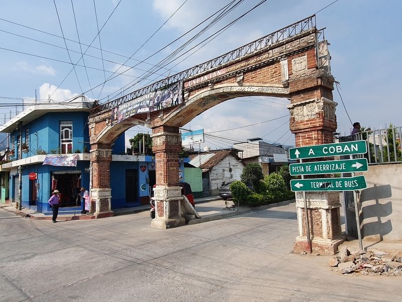
Uspantán in San Miguel Uspantán, El Quiché, Guatemala — Central America
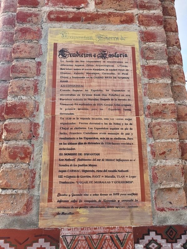
Uspantán, Land of Tradition and History
La huella de los Uspantekos la encontramos en diferentes lugares (Sitios Arqueológicos) Li’Tzaaq, Xek'ixtun, sobre el cerro Kaquljaw, la ciudad maya de Chamac, Kalante, Macalajaw, Caracolito, El Pinal Chipaj y finalmente en la Ciudad Maya de Tz’unun Kaab.
La Conquista:
Cuando llegaron los Españoles, los Uspantekos se encontraban en Tz'unun Kaab (hoy Peñaflor) en una Fortaleza rodeada de Murallas. Después de la derrota de Gumarcaj. En septiembre de 1529. Gaspar Arias preparó la primera invasión, pero los Españoles fueron derrotados.
En 1530 es la segunda invasión, esta vez venían mejor organizados. Fueron derrotados los de Nebaj y los de Chajul se rindieron. Los Uspantekos seguían en pie de lucha, Francisco Castellanos envió mensajes de paz y rendimiento a los Uspantekos, más no se rindieron. Pero en los últimos días de diciembre de 1530 fueron vencidos esclavizados.
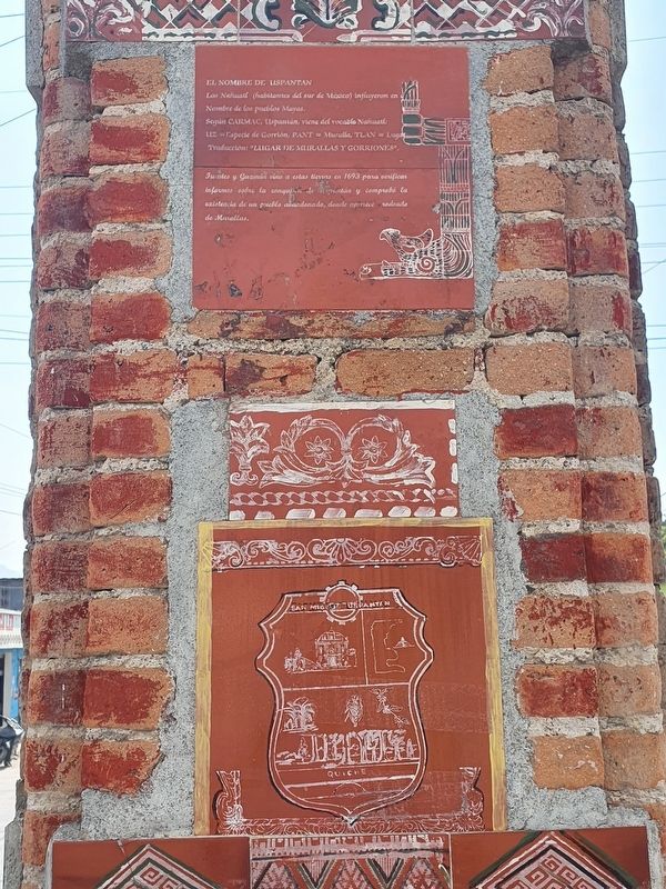
El Nombre de Uspantan
Los Nahuatl (habitantes del sur de México) influyeron en el Nombre de los pueblos Mayas.
Según Carmac, Uspantán, viene del vocablo Nahuatl:
Uz =Especie de Gorrión, Pant = Muralla, Tlan = Lugar
Traducción: "Lugar de Murallas y Gorriones".
Fuentes y Guzmán vino a estas tierras en 1693 para verificar informes sobre la conquista de Uspantán y comprobó la existencia de un puebte abandonado, donde aparece rodeado de Murallas.
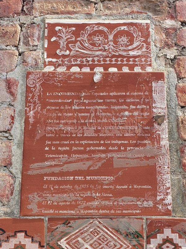
La Encomienda
Los Españoles aplicaron el sistema de "encomiendas" repartir las tierras, los esclavos, y ta riqueza de los pueblos conquistados. Uspantán, fue dado a Diego de Rojas y Santos de Figuerora, y a finales del siglo XVI fue entregado a la señora María Chinchilla.
Despues se aplicó el sistema de corregimiento y más tarde a traves de los Alcaldes Mayores, este ultime sistema fue más cruel en la explotación de los indígenas. Los pueblos de la región fueron gobernados desde la provincia Totonicapán. Uspantán, también perteneció al curato de Sacapulas.
Fundacion del municipio:
El 11 de octuhive de 1825 la ley … decretó à Uspantán, como municipio de la región de la Sierra.
El 12 de agosto de 1872 cuando se creó el departamento de el Quiché se menciona a Uspantán dentro de sus municipios
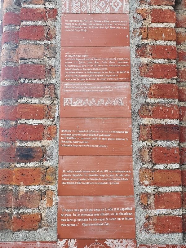
Los Uspantekos del Pinal, Las Pacayas y Chipaj, conservan muchos rasgos de su identidad, como su idioma y el traje. Los principales apellidos Uspanitekos son: Aj, Ajchicú, Ajcot. Ajpi, Ajpop, Choc, Chitop, Estená, Sic, Pinula, Méndez.
La Llegada de los K’iches
Los K’iche'li llegaron después de 1872, con el reportimiento de las tierras, vinieron de Quiché, Santa Rosa, Santa Maria, Totonicopán, Momostenango, se asentaron en las tierras altas poblando las aldeas de Calanté, Macalajau, Desengaño, Cholá, Quizachal.
Los ladinos vinieron de Huehuetenango, de San Marcos, de Quiché, de Chinique, de Momostenango, ellos ocuparon la región central.
La parte Sur (la región del Palmar) la ocuparon familias que venian del pueblo de Santa Rosa Chujuyup.
El Norte del municipio fue ccupado por los Q’eqchi, esta region se le conoce como Zona Reina por su enorme riqueza natural.
Identidad
"Es el conjunto de valores aglutimantes y estructurantes que conforman y perpetuan el sentimiento de pertenencia"
Las Cofradias: la estructura social de estes grupos preservan la identidad de nuestros pueblos. En Uspantán, hay un promedio de quince Cofradias.
El conflicto armado interno, desde el año 1979, otro sufrimiento de la población Uspanteka. La comunidad maya lo más afectada, aldeas enteras fueron arrasadas. Se recuerda la masacre de la aldea Calanté, el 14 de febrero de 1982 cuando fueron asesinadas 53 personas.
"El tesoro más grande que tengo en la vida es la capacidad de soñar. En los momentos más dificiles, en las situaciones más duras y complejas he sido capaz de soñar con un futuro más hermoso."
Rigoberta Menchú Tum
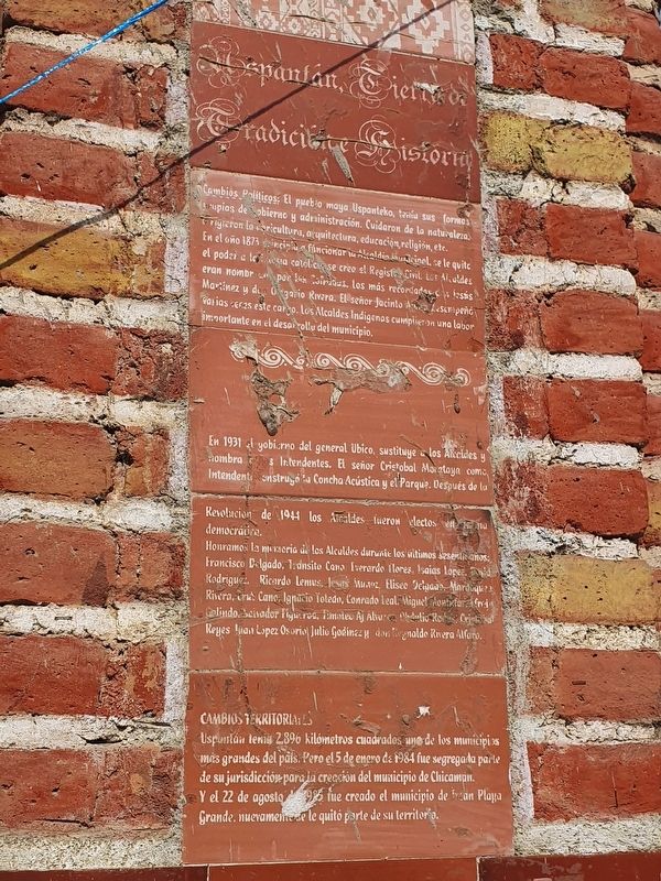
Uspantán, Tierra de Tradiciones e Historia
Cambios Politicos: El puebio maya Uspanteko, tenía sus formas propias de gobierno y administración. Cuidaron de la naturaleza, dirigieron la agricultura, arquitectura, educación, religión, etc. En el año 1873 principia a funcionar el Alcadia Municipal, se le quita el poder a la iglesia católica y se cree el Registro Civil. Los Alcaldes eran nombrados por los Cofrades. Los más recordados don Jesús Martínes y don Olegario Rivera. El señor Jacinto A… desempeñó varias veces este cargo. Los Alcaldes Indígenas cumplieron una labor importante en el desarrollo del municipio.
En 1931 el gobierno del general Ubico, sustituye los Alcaldes y nombra Intendentes. El señor Cristobal Moretaya como Intendente construyó la Concha Acústica y el Parque. Después de la Revolucion de 1944 los Alcaldes fueron electos en forma democrática.
Honramos la memoria de los Alcaldes durante los últimos sesenta años: Francisco Delgado, Transito Cano, Everardo Flores, Isaias Lopez, David Rodriguez, Ricardo Lemus, Jesús Muñoz, Eliseo Delgado, Mardoqueo Rivera, Cruz Cano, Ignacio Toledo, Conrado Leal, Miguel Montufar, ..frie Galindo, Salvador Figueroa, Timoteo Al Alvaro, Obdulio Rodas, Cristobal Reyes, Juan López Osorio, Julio Godinez y don Reynaldo Rivera Alfaro.
Cambios Territoriales:
Uspuntán tenia 2,896 kilómetros cuadrados uno de los municipios más grandes del país. Pero el 5 de enero de 1984 fue segregada parte de su jurisdicción para la creación del municipio de Chicaman. Y el 22 de agosto de 1985 fue creado el municipio de Ixcán Playa Grande, nuevamente le quitó parte de su territorio.
>Uspantan, Land of Tradition and History
The origin of the Uspantekos is found in different places, such as the archaeological sites of Li'Tzaaq, Xek'ixtun on the Kaquljaw hill, the Mayan city of Chamac, Kalante, Macalajaw, Caracolito, El Pinal Chipaj and finally in the Mayan city of Tz'unun Kaab.
The Conquest:
When the Spaniards arrived, the Uspantekos were in Tz'unun Kaab (today Peñaflor) in a fortress surrounded by walls. After the defeat of Gumarcaj, in September 1529, Gaspar Arias prepared the first invasion, but the Spaniards were defeated.
In 1530 the Spanish came with a second invasion, this time they were better organized. Nebaj was defeated and Chajul surrendered. The Uspantekos were still fighting and Francisco Castellanos sent messages of peace and terms to the Uspantekos, but they did not surrender. But in the last days of December 1530 they were finally defeated and enslaved.
The Name of UspantánÑ
The Nahuatl speakers (inhabitants of southern Mexico) influenced the name of many of the Mayan peoples.
According to Carmac, Uspantán comes from the Nahuat words: Uz = A species of hummingbird, Pant = Wall, Tlan = Place
Translation: "Place of Walls and Hummingbirds".
Fuentes y Guzmán came to these lands in 1693 to verify reports on the conquest of Uspantán and here he verified the existence of an abandoned village, where it appears surrounded by walls.
The Encomienda
The Spaniards applied the system of "encomiendas" to distribute lands, slaves and the wealth of the conquered peoples. Uspantán was given to Diego de Rojas y Santos de Figuerora, and at the end of the sixteenth century was given to María Chinchilla.
Later the corregimiento system was applied and through the system of the “Greater Mayors” it became even more cruel in the exploitation of the indigenous people. The peoples of the region were governed from the province of Totonicapán. Uspantán also belonged to the curate of Sacapulas.
Foundation of the municipality:
On October 11, 1825 the law ... decreed Uspantán as a municipality of the Sierra Region.
On August 12, 1872 when the department of El Quiché was created, Uspantán was mentioned within its municipalities.
The Uspantekos del Pinal, Las Pacayas and Chipaj, retain many features of their identity, such as their language and traditional dress. The main surnames Uspantekos are:
Aj, Ajchicú, Ajcot. Ajpi, Ajpop, Choc, Chitop, Estená, Sic, Pinula, Méndez.
The Arrival of the K'iches
The K'iche'li arrived after 1872, with the new distribution of lands, they came from Quiché, Santa Rosa, Santa Maria, Totonicopán, Momostenango, settling in the highlands and populating the villages of Calanté, Macalajau, Desengaño, Cholá and Quizachal.
The Ladinos came from Huehuetenango, San Marcos, Quiché, Chinique and Momostenango, they occupied the central region.
The southern part (the Palmar region) was occupied by families who came from the town of Santa Rosa Chujuyup.
The north of the municipality was occupied by the Q'eqchi, this region is known as Zona Reina (The Queen’s Zone) for its enormous natural wealth.
Identity
"It is the set of agglutinating and structuring values that make up and perpetuate the feeling of belonging"
The Cofradias: the social structure of these groups preserves the identity of our peoples. In Uspantán, there is an average of fifteen Cofradias.
The Internal Armed Conflict
Since 1979, this was another suffering of the Uspanteko population. The Mayan community was most affected and entire villages were razed. In particular the massacre of the village Calanté, on February 14, 1982 when 53 people were killed is memorialized.
"The greatest treasure I have in life is the ability to dream. In
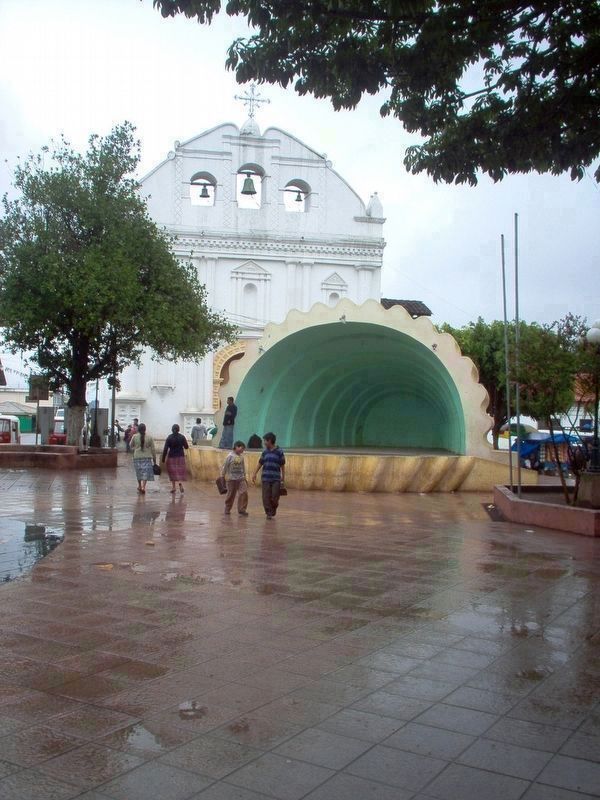
By Charles F. Beckman (CC BY-SA 3.0), January 5, 2007
7. Uspantán's Catholic Church and Acoustic Bandstand
Rigoberta Menchú Tum
Uspantán, Land of Traditions and History
Political Changes: The Mayan Uspanteko people had their own forms of government and administration. They took care of nature, directed agriculture, architecture, education, religion, etc. In 1873 the Municipal Mayor system began to operate and the power of the Catholic Church was taken away as the Civil Registry was created. The Mayors were appointed by the Brotherhoods (Cofradías). The most remembered are Jesús Martínez and Olegario Rivera. Jacinto A... held this position several times. The Indigenous Mayors played an important role in the development of the municipality.
In 1931 the government of General Ubico replaced the Mayors and appointed Intendants. Cristobal Moretaya as Intendant built the acoustic bandstand and the central park. After the Revolution of 1944 the Mayors were democratically elected.
We honor the memory of the Mayors of the last sixty years: Francisco Delgado, Transito Cano, Everardo Flores, Isaias Lopez, David Rodriguez, Ricardo Lemus, Jesús Muñoz, Eliseo Delgado, Mordequeo Rivera, Cruz Cano, Ignacio Toledo, Conrado Leal, Miguel Montufar, .. frie Galindo, Salvador Figueroa, Timoteo Al Alvaro, Obdulio Rodas, Cristobal Reyes, Juan López Osorio, Julio Godinez and Don Reynaldo Rivera Alfaro.
Territorial Changes:
Uspuntán had 2,896 square kilometers at one point and was one of the largest municipalities in the country. But on January 5, 1984, part of its jurisdiction was taken for the creation of the municipality of Chicaman. And on August 22, 1985 the municipality of Ixcán Playa Grande was created, once again taking more of its territory.
Topics. This historical marker is listed in these topic lists: Colonial Era • Native Americans • Settlements & Settlers • Wars, Non-US. A significant historical date for this entry is January 5, 1984.
Location. 15° 20.768′ N, 90° 52.334′ W. Marker is in Uspantán, El Quiché, in San Miguel Uspantán. Marker is on Route 7W, on the right when traveling east. Touch for map. Marker is in this post office area: Uspantán, El Quiché 14015, Guatemala. Touch for directions.
Credits. This page was last revised on May 30, 2022. It was originally submitted on May 30, 2022, by J. Makali Bruton of Accra, Ghana. This page has been viewed 297 times since then and 77 times this year. Photos: 1, 2, 3, 4, 5, 6, 7. submitted on May 30, 2022, by J. Makali Bruton of Accra, Ghana.
