Clinton in Prince George's County, Maryland — The American Northeast (Mid-Atlantic)
Louise F. Cosca Regional Park
Past and Present
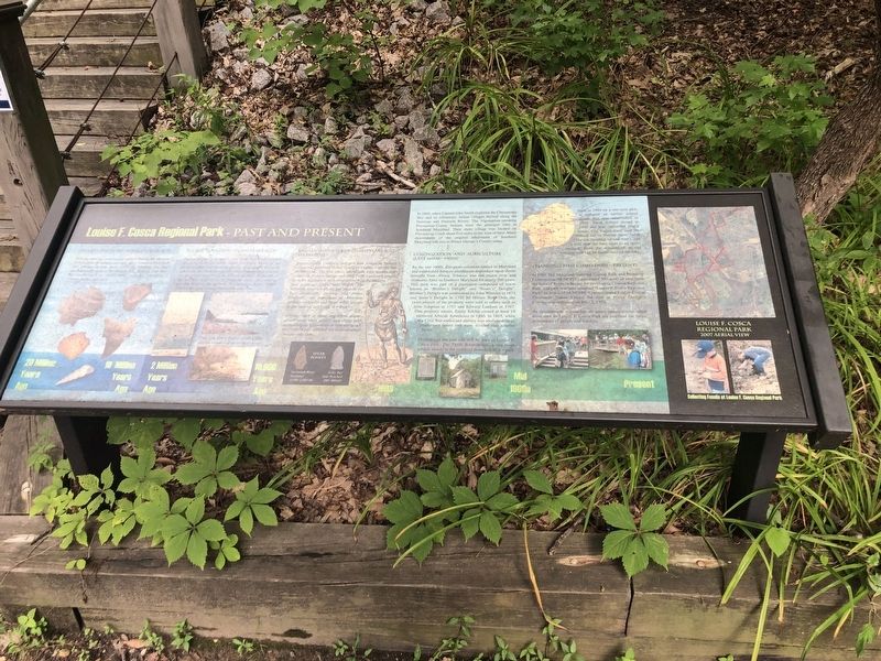
Miocene Period (20-10 Million Years Ago)
You are standing on an ancient seabed. During the Miocene period. 20 to 10 million years ago, all of Southern Maryland was a warm shallow ocean called the Miocene Sea that reached as far north as Washington D.C. Beneath your feet lay fossils such as sharks teeth, mollusks, crocodiles, whales, turtles, and more
Ice Age (2 Million - 10,000 Years Ago)
During the last 70 thousand years there were several glacial advances from the north called Ice Ages. Much of the ocean's water was stored in glaciers dramatically lowering sea levels. As the earth warmed, water from melting glaciers cut deep river channels in the former sea floor. At the end of the last Ice Age, 10 to 15 thousand years ago, melting glaciers flooded the ancient Susquehanna River Valley forming the great estuary, the Chesapeake Bay.
Did you know that Calvert Cliffs are the remains of an eroded valley?
Human Occupation (10,000 Years Ago To Present)
Archaeology evidence indicates that American Indians visited and inhabited Prince George's County over the last 10,000 years. The first native inhabitants were hunters and gatherers. Nearby springs provided fresh water and stones from the streambeds were shaped into tools for hunting and working hides and wood. The wetlands supplied plants and animals for food, medicines, clothing, and shelter. Gradually, the population of American Indians increased and large tribal groups began farming and living in villages.
Artifacts such as spear and arrow points ground stone axes, pottery, and other help archaeologists to understand how the area's first inhabitants to environmental changes over time.
In 1608, Captain John Smith explored the Chesapeake Bay and its tributaries, Indian villages thrived along the Potomac and Patuxent Rivers. The Algonquian-speaking Piscataway-Conoy Indians were the principal tribe in Southern Maryland. Their main village was located on Piscataway Creek about five miles to the west of here. Many descendants of the original inhabitants of Southern Maryland still live in Prince George's County today.
Colonization and Agriculture (Late 1600s-1900s)
By the late 1600s, European colonists settled in Maryland and established tobacco plantations dependant upon slaves brought from Africa. Tobacco was the major crop and economic force in Southern Maryland for nearly 200 years. This park was part of a plantation composed of tracts known as "Brother's Delight" and "Sister's Delight". Brother's Delight was established by John Wheeler in 1673 and Sister's Delight in 1703 by Hillary Ball. Over the years parcels of the property were sold to others such
Evidence of the past can still be seen in Louise F. Cosca Park. The Thrift Schoolhouse, a one room school, stands at the southern boundary of the park.
Built in 1884 on a one-acre plot, it replaced an earlier school house that was established in 1868. Thrift School closed in 1909 and was converted into a house. Old wagon trails near the school led to former farm fields (you are standing on one now), and a trail near the lake went to an apple orchard. Even the remains of an old whiskey still can be found west of the lake.
Changing Times (Mid 1900s-Present)
In 1962 The Maryland-National Capital Park and Planning Commission (M-NCPPC) purchased 500 acres of land from the heirs of Rebecca Berger for developing Clinton Regional Park. The park was later renamed "Louise F. Cosca Regional Park" in honor of M-NCPPC Commissioner Louis Cosca. Clearwater nature Center, the first in Prince George's County, was dedicated on May 2, 1970.
As development encroaches on green space, conservation areas such as Louise F. Cosca Park are essential for future generations of people and wildlife.
Erected by Maryland-National Capital Parks and Planning Commission.
Topics. This historical marker is listed in these topic lists: Anthropology & Archaeology • Colonial Era • Exploration • Native Americans. A significant historical date for this entry is May 2, 1970.
Location. 38° 44.008′ N, 76° 55.078′ W. Marker is in Clinton, Maryland, in Prince George's County. Marker can be reached from Thrift Road, 0.3 miles west of West Boniwood Turn, on the right when traveling west. Touch for map. Marker is at or near this postal address: 11000 Thrift Rd, Clinton MD 20735, United States of America. Touch for directions.
Other nearby markers. At least 8 other markers are within 4 miles of this marker, measured as the crow flies. Thrift School (approx. 0.3 miles away); John Wilkes Booth (approx. 2.4 miles away); Surratt Tavern (approx. 2.4 miles away); a different marker also named John Wilkes Booth (approx. 2.4 miles away); The Mary Surratt House (approx. 2.4 miles away); Crucifix (approx. 2.6 miles away); “Coach” James W. Crawford (approx. 3.1 miles away); T. B. (approx. 3.2 miles away). Touch for a list and map of all markers in Clinton.
Additional commentary.
1. Dates and References
'Bryan Hall' has since changed hands a number of times. On 18 April 1914, Sidney and Mary Ida Mudd's children sold the tract and all outstanding debts were paid by Rebecca Berger of Pittsburgh. This was just two months following the Rambler news story. Locals in the area frequently refer to the area as the "Old Berger Farm" sometimes erroneously in context Berger held onto the property until 1939 when she died and transferred it to her son. During that time, she had sold a portion for the "Louise Cosca Regional Park", the Surratts-Clinton Library and the Leonard Dyer Regional Health Center.
On 19 Jul 1963 'part of' the '769 acre tract' was transferred from the Berger heirs to the Maryland-National Capital Park and Planning Commission (MNCPPC) and the Board of Education under Margaret Berger Deed of Trust. This was the time a concrete monument was erected near the Library and to the Bryan memory. The last remaining 247 acres were purchased by Prince Georges Community College in 1969. Note To Editor only visible by Contributor and editor
— Submitted October 8, 2023, by Mike Williamson of Forest Hill, Maryland.
Credits. This page was last revised on October 17, 2023. It was originally submitted on August 9, 2020, by Devry Becker Jones of Washington, District of Columbia. This page has been viewed 526 times since then and 56 times this year. Last updated on June 6, 2022, by Bruce Guthrie of Silver Spring, Maryland. Photos: 1, 2. submitted on August 9, 2020, by Devry Becker Jones of Washington, District of Columbia.

