Sterling in Loudoun County, Virginia — The American South (Mid-Atlantic)
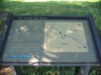
The Vestal's Gap Road
It began as an animal trail, then was adopted by the Native Americans in this region as their path, and later was used by settlers as they moved from tidewater Virginia to that colony's western frontier.
Due to its association with people and events important in American history, a notable historian stated that it should be classified as one of the most historic roads in the United States.
Topics. This historical marker is listed in these topic lists: Native Americans • Roads & Vehicles • Settlements & Settlers.
Location. 39° 1.132′ N, 77° 24.374′ W. Marker is in Sterling, Virginia, in Loudoun County. Marker is on Old Vestals Gap Road, on the right when traveling east. Located along the walking path and service road which follows the old road trace in Claude Moore Park. Touch for map. Marker is in this post office area: Sterling VA 20164, United States of America. Touch for directions.
Other nearby markers. At least 8 other markers are within walking distance of this marker. George Washington (within shouting distance of this marker); a different marker also named George Washington (about 400 feet away, measured in a direct line); The Braddock Campaign (about 700 feet away); Guilford Signal Station (about 700 feet away); a different marker also named Vestal's Gap Road (about 700 feet away); a different marker also named Vestal's Gap Road (about 700 feet away); Lanesville Architecture (about 700 feet away); Lanesville Historic Area (about 800 feet away). Touch for a list and map of all markers in Sterling.
Credits. This page was last revised on December 30, 2020. It was originally submitted on June 17, 2009, by Craig Swain of Leesburg, Virginia. This page has been viewed 4,228 times since then and 38 times this year. Photos: 1. submitted on June 17, 2009, by Craig Swain of Leesburg, Virginia. 2. submitted on December 30, 2020, by Devry Becker Jones of Washington, District of Columbia.

