Ocala in Marion County, Florida — The American South (South Atlantic)
The Treaty of Moultrie Creek
Fort King National Historic Landmark
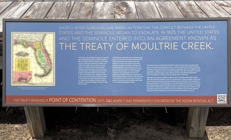
Shortly after Florida became American Territory, the conflict between the United States and the Seminole began to escalate. In 1823, the United States and the Seminole entered into an agreement known as The Treaty of Moultrie Creek.
The treaty was intended to ease the conflict and to establish what land would be inhabited by each. It proposed that the Seminole must relocate to a four-million-acre reservation located in the middle of the state. Per the treaty, the United States would afford the Seminole protection, husbandry, livestock and an annual sum of five thousand dollars. The treaty also promised them an agent, interpreter, blacksmith and a school. In return, the Seminole must relinquish all claims to any other land they had previously occupied in Florida, assist in the capturing and returning of run-away slaves or fugitives, and allow roads to be built for occasional passage by others through the reservation.
The Treaty of Moultrie Creek was not a good deal for the Seminole. The lands the Seminole had previously occupied were prized by American settlers, not only for their superior agricultural potential, but because the lands and fields were already established by the Seminole as their own farms and ranches and thus were lands proven to be fertile and productive, The newly proposed reservation would yield areas that were not prepared nor suitable for farming and agriculture. The centralized location of the new reservation also cut the Seminole off from the coasts. This would prevent further trade with the Spanish and English which would include weapons trading.
The treaty was a continuous a attempt to quell the Seminole, who had already lost so much since the beginning of the war in 1816. The signing of the treaty took place at Moultrie Creek located south of St Augustine. Neamathla, a prominent Mikasuki Chief, was chosen to speak for many of the Seminole people. Some Seminole leaders, including Neamathla, signed the treaty. Others refused, and there was general disagreement within the tribe about whether those who signed were a voice for all.
(Caption)
The highlighted section in green in the state’s interior outlines the territory the treaty assigned to the Seminole.
Erected by Florida Department of State/Division of Historical Resources.
Topics. This historical marker is listed in these topic lists: Forts and Castles • Native Americans • Wars, US Indian. A significant historical year for this entry is 1823.
Location. 29° 11.224′ N, 82° 4.985′ W. Marker is in Ocala, Florida, in Marion County. Marker can be reached from the intersection of East Fort King Street and SE 39th Avenue, on the left when traveling east. Marker is located on the grounds of the Fort King National Historic Landmark. Touch for map. Marker is at or near this postal address: 3925 E Fort King St, Ocala FL 34470, United States of America. Touch for directions.
Other nearby markers. At least 8 other markers are within walking distance of this marker. Treaty of Payne’s Landing (here, next to this marker); Dade Massacre (a few steps from this marker); Attack on Fort King (within shouting distance of this marker); It was a Hard Life at Fort King (within shouting distance of this marker); The Second Seminole War / The Third Seminole War (within shouting distance of this marker); The U.S. Army on the frontier (within shouting distance of this marker); The First Seminole War (within shouting distance of this marker); The Seminole War (within shouting distance of this marker). Touch for a list and map of all markers in Ocala.
Also see . . .
1. The Treaty of Moultrie Creek. (Submitted on July 8, 2022, by Brandon D Cross of Flagler Beach, Florida.)
2. Fort King National Historic Landmark. (Submitted on July 8, 2022, by Brandon D Cross of Flagler Beach, Florida.)
Credits. This page was last revised on July 9, 2022. It was originally submitted on July 8, 2022, by Brandon D Cross of Flagler Beach, Florida. This page has been viewed 206 times since then and 37 times this year. Photos: 1, 2. submitted on July 8, 2022, by Brandon D Cross of Flagler Beach, Florida. • Bernard Fisher was the editor who published this page.

