Paris in Lamar County, Texas — The American South (West South Central)
Burial Site of John S. Chisum
(1824-1884)

Photographed by Cajun Scrambler
1. John S. Chisum Marker
Cattle baron whose herds, moving from east to west Texas and into New Mexico, expanded into one of the greatest cattle spreads in the west.
Coming from Tennessee to Paris, 1837, Chisum joined S. K. Fowler in a cattle venture in Denton County, 1854. During the Civil War, he supplied beef to Confederate troops west of the Mississippi and his cowboys guarded the frontier against Indians.
After moving in 1864 to the Concho River, then to "Bosque Grande" on the Pecos, he finally located his spread at South Spring near Roswell, New Mexico, 1873. His enormous herds-- 60,000 to 100,000 head-- pounded trails across Texas into New Mexico. His name and fame led to confusion with Jesse Chisholm, blazer of part of the historic Texas-to-Kansas cattle trail.
Chisum's onetime partner, famous cattleman Charles Goodnight, said that Chisum, who could correctly tally three grades of moving cattle at once, was the best counter he knew. Chisum's distinctive "Long Rail" brand and "Jinglebob" ear-notch defied alteration.
A disastrous packing house deal and involvement in the 1876 "Lincoln County War," in which Billy the Kid and various cattle factions figured, ultimately led to Chisum's financial ruin.
Erected 1967 by State Historical Survey Committee. (Marker Number 8190.)
Topics. This historical marker is listed in these topic lists: Agriculture • Cemeteries & Burial Sites • Industry & Commerce • Settlements & Settlers. A significant historical year for this entry is 1837.
Location. 33° 39.211′ N, 95° 34.036′ W. Marker is in Paris, Texas, in Lamar County. It is on Washington Street 0.1 miles west of 10th Street SW, on the left when traveling west. The marker is on Washington Street next to a rail crossing. Touch for map. Marker is in this post office area: Paris TX 75460, United States of America. Touch for directions.

Regionally,
this page online
Other nearby markers. At least 8 other markers are within walking distance of this marker: Union Station (approx. half a mile away); Origin of the Paris Fire of 1916 (approx. half a mile away); Central National Road (approx. half a mile away); Sanitarium of Paris / McCuistion Community Hospital (approx. half a mile away); First Presbyterian Church (approx. 0.6 miles away); Paris Cotton Compress (approx. 0.6 miles away); In Memory of David Crockett (approx. 0.7 miles away); Judge Wm. Henry Lightfoot House (approx. 0.7 miles away). Touch for a list and map of all markers in Paris.

Photographed by Cajun Scrambler
2. John S. Chisum Marker
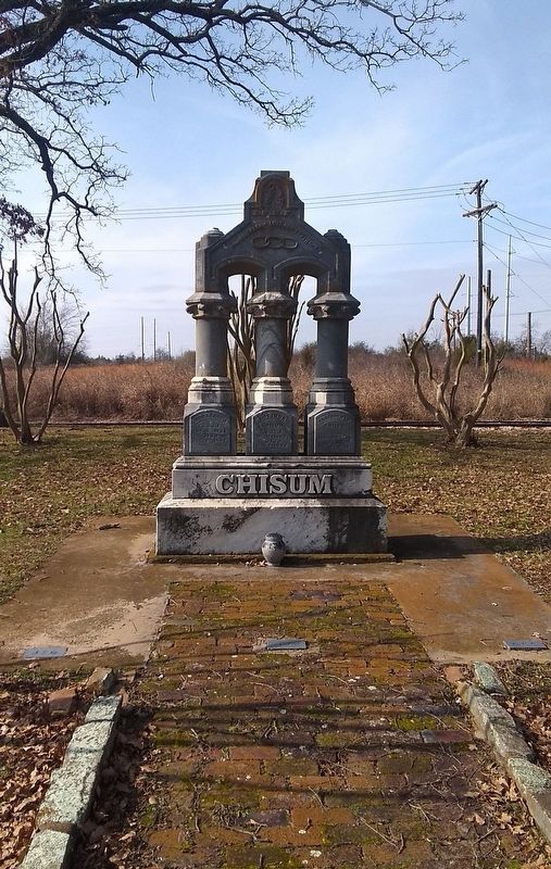
3. John S. Chisum grave site.
Credits. This page was last revised on November 25, 2024. It was originally submitted on January 18, 2019, by Cajun Scrambler of Assumption, Louisiana. This page has been viewed 2,554 times since then and 256 times this year. Last updated on July 11, 2022, by Joe Lotz of Flower Mound, Texas. Photos: 1, 2, 3. submitted on January 18, 2019. • J. Makali Bruton was the editor who published this page.
