Silver Bay in Lake County, Minnesota — The American Midwest (Upper Plains)
Welcome to the Silver Bay Safe Harbor/Marina
Why Safe Harbors?
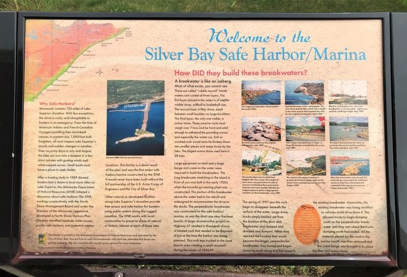
Minnesota contains 150 miles of Lake Superior shoreline. With few exceptions, the shore is rocky and inhospitable to boaters in an emergency. From the time of American Indians and French-Canadian Voyagers paddling their birch-bark canoes, to present day 1,000-foot bulk freighters, all must respect Lake Superior's moods and sudden changes in weather. Even on sunny days in July and August, the lake can turn into a tempest in a few short minutes with gusting winds and white-capped waves. Small boats must have a place to seek shelter.
After a boating study in 1989 showed boaters had a desire to boat more often on Lake Superior, the Minnesota Department of Natural Resources (DNR) initiated a discussion about safe harbors. The DNR, working cooperatively with the North Shore Management Board and under the direction of the Minnesota Legislature, developed a North Shore Harbors Plan. The plan identified landside water access points, safe harbors, and potential marina locations. This facility is a direct result of the plan and was the first major safe harbor/marina constructed by the DNR. It would never have been built without the full partnership of the U.S. Army Corps of Engineers and the City of Silver Bay.
Other natural or developed facilities along Lake Superior's shoreline provide free access and safe harbor for boaters using public waters along this rugged coastline. The DNR works with local communities to preserve areas of natural or historic interest at each of these sites.
photo:
Summer 2000. Newly opened marina.
How DID they build these breakwaters?
A breakwater is like an iceberg. Most of what exists, you cannot see. These are called "rubble mound" breakwaters and consist of three layers. The first layer placed in the water is of smaller rubble stone, softball to basketball size. The second layer is filter stone, sized between small boulders to large boulders. The final layer, the only one visible, is armor stone. These massive rocks must weigh over 7 tons and be hard and solid enough to withstand the pounding waves and especially the winter ice. Soft or cracked rock would soon be broken down into smaller pieces and swept away by the lake. The largest armor stone used here is 28 tons.
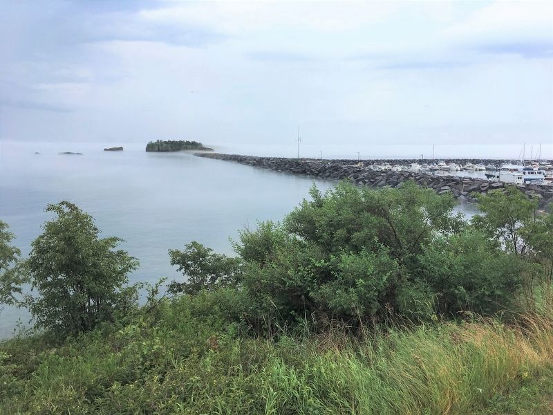
Large equipment on land and a large barge and crane on the water were required to build the breakwaters. The long breakwater stretching to the island in front of you was built in the early 1950s when the taconite processing plant was constructed. The portion of this breakwater above the water had to be rebuilt and redesigned to accommodate the drive to the docks. The perpendicular breakwater was constructed for the safe harbor/marina, as was the short one near the boat launch. A large reconstruction project on Highway 61 resulted in thousands of tons of blasted rock that needed to be disposed of just at the time the harbor was being planned. This rock was trucked to the boat launch area creating a small mountain during the winter of 1996-97.
The spring of 1997 saw this rock begin to disappear beneath the surface of the water. Large dump trucks simply backed out from the location of the short stub breakwater and dumped and dumped and dumped. When they reached the location that would become the longer, perpendicular breakwater, they turned and began dumping north along that line towards the existing breakwater. Meanwhile, the existing breakwater was being modified so vehicles could drive down it. This allowed trucks to begin dumping south on the perpendicular breakwater until they met where the trucks dumping north had ended. All the material placed for the road in the marina mouth was then removed and the crane barge was brought in to place the filter and armor stone.
All of the armor stone visible came from a taconite mine in Babbitt, Minnesota, 52 miles away. Twenty-five trucks made two trips per day, seven days a week for three months. Trucks could haul up to four rocks per trip. Over 92,000 tons of rock was used in the breakwater construction.
photos:
The original breakwater, constructed in the early 1950s.
Stub breakwater under construction. The core stone and the filter stone were stored in the same quarry that supplied the rock for the original breakwater. April 1997
Road on stub breakwater—the main breakwater is moving north. Lights were used for working at night. May 1997
Reconstruction work on the original breakwater. July 1997
Filter stone is dumped into a "skip," a large flat bucket controlled by the crane. July 1997
The skip is lowered into the water at precisely the correct position and then the rock is dumped. July 1997
The armor stone was trucked from Babbitt, 52 miles away. The weight of each stone was painted on its side to prevent overloading the trucks and to help the contractor quickly identify the largest stones to place in appropriate locations on the breakwater. July 1997
The stone in the quarry location is greatly diminished (upper right) as the armor stone stockpile grows (lower left). August 1997
After the armor stone was placed, the crane barge rearranged the individual stones so that they interlocked and created the flat appearance you see today. September 1997
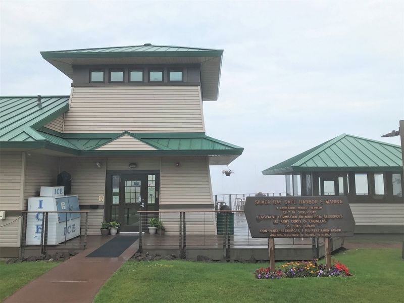
This facility is owned by the Minnesota Department of Natural Resources and operated by the City of Silver Bay. You are free to walk the breakwater only and are reminded that boats are private property. The city maintains the nearby picnic ground for your enjoyment.
Displays produced by the Minnesota Department of Natural Resources
Erected by Minnesota Department of Natural Resources.
Topics. This historical marker is listed in these topic lists: Parks & Recreational Areas • Waterways & Vessels. A significant historical year for this entry is 1989.
Location. 47° 16.377′ N, 91° 16.487′ W. Marker is in Silver Bay, Minnesota, in Lake County. Marker is on Marina Drive, 0.3 miles east of Bayside Park Road, on the left. Located at the Silver Bay Safe Harbor Public Marina off Highway 61. Touch for map. Marker is at or near this postal address: 99 Beach Drive, Silver Bay MN 55614, United States of America. Touch for directions.
Other nearby markers. At least 8 other markers are within 7 miles of this marker, measured as the crow flies. A Modern Shipwreck (here, next to this marker); Historic Shipwrecks (here, next to this marker); Taconite Mining (here, next to this marker); Northshore Mining (approx. 1.4 miles away); Lake Superior Shipwrecks (approx. 1.6 miles away); About the City: Silver Bay, Minnesota (approx. 1.6 miles away); Palisade Head (approx. 4.3 miles away); Geology of the Split Rock Region (approx. 6.6 miles away). Touch for a list and map of all markers in Silver Bay.
Credits. This page was last revised on August 9, 2022. It was originally submitted on August 7, 2022. This page has been viewed 170 times since then and 37 times this year. Photos: 1, 2, 3. submitted on August 7, 2022. 4. submitted on August 8, 2022. 5. submitted on August 9, 2022. 6. submitted on August 7, 2022.
