Winchester in Frederick County, Virginia — The American South (Mid-Atlantic)
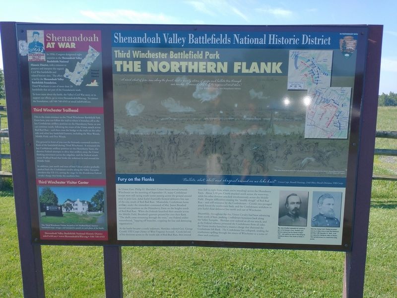
The Northern Flank
Third Winchester Battlefield Park
— Shenandoah Valley Battlefields National Historic District —
Inscription.
(left panel)
Shenandoah At War
In 1996, Congress designated eight counties as the Shenandoah Valley Battlefields National Historic District, with a mission to preserve and interpret the region's Civil War battlefields and related historic sites. The effort is led by the Shenandoah Valley Battlefields Foundation. Third Winchester is one of more than 20 battlefields that are part of t Foundation's work.
To learn more about the battle, the Valley's Civil War story, or to support our efforts, go to www.ShenandoahAtWar.org. To contact the Foundation, call 540-740-4545 or email [email protected].
Third Winchester Trailhead
This is the main entrance to the Third Winchester Battlefield Park. From here, you can follow the trail to where it branches off to the key Confederate artillery position on the Huntsberry Farm, or you can continue south, following the route of the Union attack across Red Bud Run—and then cross the bridge to the trails on the other side and other key battlefield features, including the West Woods, Middle Field, and First Woods.
The ground in front of you was the furiously-contested northern flank of the battlefield during Third Winchester. It witnessed the key Confederate artillery position on the Huntsberry Farm, the abortive Federal attempts to drive that artillery away, the Union flanking movement across the ridgeline, and the Federal attack across Redbud Road that broke the stalemate in and around the Middle Field.
In addition, just north and west of here Union cavalry gradually pushed back the Confederate cavalry along the Valley Tumpike (modern-day US-11), setting the stage for the thunderous Federal cavalry charge that broke the southern line.
Third Winchester Visitor Center
The Third Winchester Visitor, located at 541 Rodbad Road, features battlefield maps, images, and interpretive panels on each phase of the battle.
Shenandoah Valley Battlefields National Historic District
[email protected] • www.ShenandoahAtWar.org • 540-740-4545
(right panel)
Fury on the Flanks
"Bullets, shot, shell and shrapnel rained on us like hail” -Union Capt. Russell Hastings, 23nd Ohio, Duval's Division, VIII Corps
As Union Gen. Philip H. Sheridan's Union forces moved towards Winchester on the morning of September 19, many Confederate troops were still racing south (some passing across the ground around you) to join Gen. Jubal Early's hurriedly formed defensive line east of the city, south of Red Bud Run. Meanwhile, Confederate horse artillery under the immediate command of Maj. James Breathed moved into position on the
Huntsberry Farm on the heights north of Red Bud Run. When the Federals launched their assaults across the Middle Field, Breathed's gunners poured fire into their flank. "The shells came screaming through the trees,” one Federal soldier remembered, "lopping off branches, crippling the line and destroying organization.
As the battle became a costly stalemate, Sheridan ordered Gen. George Crook's VIII Corps (Army of West Virginia) forward. Crook led one of his divisions across to the north side of Red Bud Run, then moved west (left to right from where you're standing) across the Huntsberry Farm. About 3:30 pm, Crook attacked south across the waterway while his other division attacked simultaneously across the Middle Field. Despite difficulties crossing the "muddy slough” of Red Bud Run—and stiff resistance by the Confederates—Crook's two-pronged attack forced the southerners back, and the Confederates withdrew to join Early's final defensive line north and east of Winchester.
Meanwhile, throughout the day, Union Cavalry had been advancing from north of here, pushing Confederate horsemen back along the Valley Turnpike. Sheridan now ordered an all-out attack, and as the Federal infantry pressured the Confederates from all sides, the Union cavalry launched a massive charge that shattered the Confederate left flank. The Confederate line collapsed, sending the southerners spilling through the streets of Winchester in a scene of chaos and confusion.
(captions)
"A vivid sheet of fire...ran along the front, and a deadly storm of grape and bullets tore through our ranks. It seemed as if half of the regiment went down." -Col. William S. Lincoln, 34th Massachusetts Infantry
This Alred Waud sketch shows the Federals attacking the Confederates in their final L-shaped defensive position. Courtesy Library of Congress
Mai. James Breathed commanded the Confederate guns on the Huntsberry Farm. Breathed's guns had been captured from the Federals in August 1862 — and would be lost back to them during the Confederate defeat at Tom's Brook on October 9, 1864.
Union Gen. George Crook's flanking movements were key to Union victory at both Third Winchester and Fisher's Hill (September 22, 1864). Crook was captured by Confederate raiders in February 1865 and held prisoner for a month before being paroled.
Erected by Shenandoah Valley Battlefields Foundation.
Topics. This historical marker is listed in this topic list: War, US Civil. A significant historical date for this entry is September 19, 1864.
Location. 39° 12.606′ N, 78° 7.643′ W. Marker is in Winchester, Virginia, in Frederick County. Marker can be reached from Redbud Road (Virginia Route 661) 0.9 miles east of Martinsburg Pike (U.S. 11), on the right when traveling east. Located in the parking lot of the Third Winchester Battlefield Park. Touch for map. Marker is at or near this postal address: 541 Redbud Rd, Winchester VA 22603, United States of America. Touch for directions.
Other nearby markers. At least 8 other markers are within walking distance of this marker. Third Battle of Winchester (here, next to this marker); The Association for the Preservation of Civil War Sites (APCWS) (a few steps from this marker); "Like A Thousand Bricks" (a few steps from this marker); Ritchie Interpretive Plaza (within shouting distance of this marker); Three Battlefields (within shouting distance of this marker); The First Battle of Kernstown (within shouting distance of this marker); The First Battle of Winchester (within shouting distance of this marker); The Second Battle of Winchester (within shouting distance of this marker). Touch for a list and map of all markers in Winchester.
Also see . . . The Third Battle of Winchester. Shenandoah Valley Battlefields National Historic District (Submitted on August 18, 2022.)
Credits. This page was last revised on August 18, 2022. It was originally submitted on August 18, 2022, by Craig Doda of Napoleon, Ohio. This page has been viewed 156 times since then and 24 times this year. Photos: 1, 2. submitted on August 18, 2022, by Craig Doda of Napoleon, Ohio. • Bernard Fisher was the editor who published this page.

