Dushore in Sullivan County, Pennsylvania — The American Northeast (Mid-Atlantic)
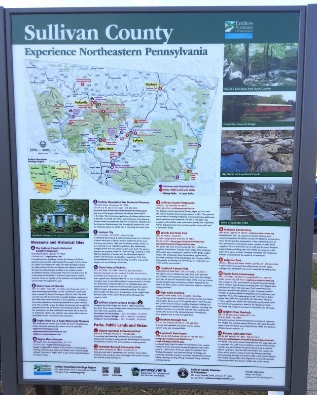
Sullivan County
Experience Northeastern Pennsylvania
[Left center photo caption reads] Baldwin House at the Sullivan County Historical Society
Museums and Historical Sites
A The Sullivan County Historical Society's Museum
458 Meylert Street, Laporte, PA 18626
570-946-5020. scpahistory.com
A complex of four buildings houses the history of Sullivan County preserving the past, through the present, for the future for visitors and researchers alike. The Main Building includes an 1880 portion with its own history and research materials. The Barn and Shed display artifacts of an outdoor nature. The Baldwin House (1850) is the first home erected on Lot #1 in the newly formed (1847) Sullivan County seat of Laporte. Summer hours are posted on the website, and appointments can be made throughout the year.
B Ghost Town of Celestia
GPS: 41.42297, -76.52448 1.5 miles west of Laporte on Rt. 42
Peter Armstrong established a divine "commune community here to await the Second Coming of Christ in 1850. The town was laid out with the intent of eventually building a tabernacle, but there were never more than a few buildings. To emphasize his secular separation, Armstrong deeded four square miles to God. The Lord did not pay the taxes; Armstrong's son bought the property at tax sale. By the time of Armstrong's death in 1887, the momentum for this settlement had waned and it returned to wilderness. Visitors can walk the main street with brochures (provided on-site) to envision what was there.
C Eagles Mere Air, & Auto/Motorcycle Museum
The museums are located just outside the town of Eagles Mere.
Please check the websites for current hours of operation.
eaglesmereairmuseum.org
eaglesmeremotorcyclemuseum.com
eaglesmereautomuseum.com
D Eagles Mere Museum
288 Eagles Mere Ave, Eagles Mere, PA 17731
570-525-3155 eaglesmeremuseum.com
Engage in Eagles Mere history at the museum, including glass making, a Chautauqua, early resort hotels, and a narrow-gauge railroad. The town of Eagles Mere is part of the National Register of Historic Places
E Endless Mountains War Memorial Museum
103 Main Street, Sonestown, PA 17758
Turn off U.S. Rt. 220 at town sign 570-482-2610
facebook.com/EndlessMountainsWarMemorial Museum
Visit one of the largest collections of military memorabilia in the state. This tremendous gathering of military artifacts aims to educate our youth and honor our heritage by remembering all who served to protect the freedom we cherish. Artifacts from the American Revolutionary War through the present day, with an emphasis placed on World War II, including the home front.
F Jamison City
GPS: 41.310294, -76.356750 Historical Sign
In 1888 the Bloomsburg & Sullivan Railroad was run to the foot of North Mountain to tap the lumber wilderness of the area. A tannery was built in 1889 and the Fishing Creek Lumber Co. was claiming to cut 100,000 board feet a day. Additionally, a wagon-wheel hub and veneer factory were built. The tannery became the property of the Elk Creek Tanning Company in 1893. With the depletion of lumber and the diminished need for leather and harnesses, all operations ceased by 1925. Only the smokestack and a tanning building are left to witness the heyday of a once-thriving community.
G Ghost Town of Ricketts
GPS: 41.39288, -76.27984 Historical Sign information
Ricketts is located 4.2 miles north of the Lake Jean entrance to Ricketts Glen State Park on Rt. 487.
Now a ghost town, Ricketts (1890-1913) was a major lumber-mill company town of over 800 residents. It was named for Civil War Col. Robert Bruce Ricketts (1839-1918) of Wilkes-Barre who owned the land. Trexler and Turrell Lumber leased the land in 1890 to timber and produce softwood products. The town boomed after the Bowman's Creek Branch of the Lehigh Valley Railroad (1887-1963) was finally completed through this region in 1893.
H Sullivan County Covered Bridges
Designed by Sadler Rogers and built in 1850, these three Burr Arch Truss covered bridges were constructed by landowners who often had a gristmill nearby.
Sonestown Covered Bridge - GPS: 41.346420, -76.555107
Forksville Covered Bridge - GPS: 41.488418, -76.599959
Hillsgrove Covered Bridge - GPS: 41.460832, -76.670767
Parks, Public Lands and Vistas
1 Elkland Township Recreational Park
909 T426, Forksville, PA 18616 570-924-3986
A municipal park featuring a soccer field, baseball field, playground including a swing set with handicapped accessibility and beautiful scenery. Pets are prohibited on park grounds.
2 Forksville Borough Community Park
Main Street, Forksville, PA 18616 570-924-3214
One-acre park with a basketball court, pavilion, picnic tables, barbecue pits, swing set, sand box/digger, slide combo monkey bar and the spring rocking sets.
3 Sullivan County Fairgrounds
4430 Rt. 154, Forksville, PA 18616
(570) 924-3205 sullivancountyfair.com
The Sullivan County Agricultural Society began in 1852, with the present location becoming permanent in 1891. The grounds are utilized for wedding receptions, memorial services, gatherings, family reunions and fundraisers. The Fair is held Labor Day weekend with exhibits, rides, concession stands and competitive entries displayed, plus horse and pony pulls, tractor pulls and a demolition derby.
4 Worlds End State Park
GPS: 41.471615, -76.581577
82 Cabin Bridge Road, Forksville, PA 18616
570-924-3287 dcnr.pa.gov/State Parks/FindAPark/WorldsEndStatePark/Pages/default.aspx
The park's 780 acres are surrounded by the 114,000-acre Loyalsock State Forest. Geologic forces shaped the landscape of this state park, creating the Loyalsock Creek gorge, rugged terrain, and spectacular vistas. Recreational opportunities, including camping, hiking, backpacking, trail running, wildlife photography, picnicking, and swimming, are waiting for you in this pristine environment.
4 Loyalsock Canyon Vista
at Worlds End State Park GPS: 41.462420, -76.574913
The highest point in Worlds End State Park, at an elevation of 1750 feet, is the Loyalsock Canyon Vista. From this vantage point can be seen the serpentine shape of the creek as it carves its way through steep mountainous terrain. Adjacent to the Vista is the Rock Garden, where visitors can explore a labyrinth of huge boulders.
5 High Knob Overlook
Loyalsock State Forest GPS: 41.44387, -76.67844
The road to High Knob Overlook was constructed by the Civilian Conservation Corps circa 1935 for good reason: from this vista you can see over 25 miles in multiple directions, looking over a vast expanse of remote forest lands in Sullivan, Lycoming and Bradford counties. It is a favorite place to view a spectacular sunset. Also as one of the darkest places in Pennsylvania, it is a popular area to view the night skies.
6 Dushore Borough Park
U.S. Rt. 220, Dushore, PA 18614 570-928-8020
The park has basketball and tennis courts, swings, a picnic area, and a baseball field.
7 Loyalsock State Forest
6735 U.S. Rt. 220, Dushore, PA 18614 570-946-4049
dcnr.pa.gov/StateForests/FindAForest/Loyalsock/Pages/default.aspx
Loyalsock State Forest is named for Loyalsock Creek, a scenic freestone stream that winds its way through the heart of the forest's 114,819 acres. The forest spans the Northern Tier's "Endless Mountains" and features flaming fall foliage and cascading waterfalls. Outdoor recreation opportunities include hiking, camping, hunting, fishing, horseback riding, canoeing and sight-seeing.
[Photo captions at right, top to bottom, read]
World's End State Park Rock Garden
Forksville Covered Bridge
Haystacks on Loyalsock Creek
Town of Ricketts 1908
8 Mokoma Conservancy
Lake Road, Laporte, PA 18626 mokomaconservancy.org
Established in 2001 by a group of forward-thinking and concerned residents of Sullivan County, the Mokoma Conservancy set as its first goal the preservation of key watershed areas of the Lake Mokoma and Laporte areas. Located on Lake Road roughly 8/10 of a mile from U.S. Rt. 220, this 244-acre forested property features hiking trails and wildlife and is open to the public from dawn to dusk. Camping, campfires and motorized vehicles are prohibited. No pavilions or restrooms.
9 Cosgrove Park
Corner of Cherry and Maple Streets, Laporte, PA 570-946-5048
A quaint community park that offers plenty of open space, a playground, basketball court and a seasonal ice-skating rink.
10 Eagles Mere Conservancy
GPS: 41.410291, -76.574414 Located off Rt. 42, near the
Outlet Pond 570-525-3725 eaglesmereconservancy.org
This property's 373+ acres features wooded mountain slopes with 3 miles of blazed trails connecting with other Eagles Mere trails laid out nearly 100 years ago. The Conservancy has a full-time naturalist and supports a variety of nature-oriented activities, including children's programs, evening lectures, and organized hikes. The headquarters is the Conservancy Cabin beside the Outlet Pond just off Rt. 42. This cabin, dating to 1734 or earlier, was saved from demolition and reconstructed on Conservancy property to serve as an Education Center. The lands and programs are open to the public free of charge.
11 Wright's View Overlook
Old U.S. Rt. 220, Muncy Valley, PA 17758
GPS: 41.37797, -76.51655
Named in honor of former Pennsylvania Secretary of Highways P.D. Wright, this overlook along Old Route 220 boasts beautiful views of the mountains surrounding Muncy Valley and portions of State Game Lands No. 13.
12 Ricketts Glen State Park
695 Rt. 487, Benton, PA 17814 570-477-5675
dcnr.pa.gov/State Parks/FindAPark/RickettsGlenState Park
One of the most scenic areas in Pennsylvania, this large state park is comprised of 13,189 acres in Sullivan, Luzerne and Columbia counties and also harbors the Glens Natural Area, a National Natural Landmark. Hike the Falls Trail System and explore the Glens, which boasts a series of wild, free-flowing waterfalls, each cascading through rock-strewn clefts in this ancient hillside. The 94-foot Ganoga Falls is the highest of 22 named waterfalls. Old-growth timber and diverse wildlife add to the beauty.
Erected by Sullivan County Chamber of Commerce, Endless Mountains Heritage Region, and PA DCNR.
Topics. This historical marker is listed in these topic lists: Environment • Industry & Commerce • Parks & Recreational Areas • Settlements & Settlers. A significant historical year for this entry is 1880.
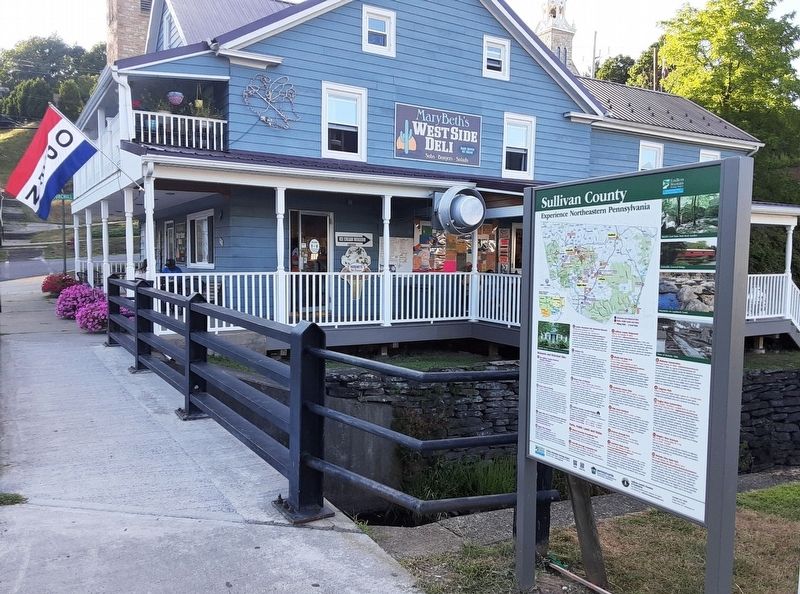
Location. 41° 31.48′ N, 76° 24.12′ W. Marker is in Dushore, Pennsylvania, in Sullivan County. Marker is at the intersection of Main Street and Marsh Run, on the right when traveling west on Main Street. Touch for map. Marker is at or near this postal address: 132 West Main Street, Dushore PA 18614, United States of America. Touch for directions.
Other nearby markers. At least 8 other markers are within walking distance of this marker. Veterans Memorial (about 300 feet away, measured in a direct line); M. Eugene Deegan (about 400 feet away); Joseph and Mary Ann Litzelswope (about 500 feet away); World War Memorial (about 600 feet away); Civil War Memorial (about 600 feet away); Korean War Memorial (about 600 feet away); Vietnam War Memorial (about 600 feet away); Spanish American War Memorial (about 600 feet away). Touch for a list and map of all markers in Dushore.
Credits. This page was last revised on September 5, 2022. It was originally submitted on September 5, 2022, by William Fischer, Jr. of Scranton, Pennsylvania. This page has been viewed 239 times since then and 22 times this year. Photos: 1, 2. submitted on September 5, 2022, by William Fischer, Jr. of Scranton, Pennsylvania.

